Before 1400, as earlier chapters explained, several peoples had developed maritime cultures. The most extraordinary of these was the Polynesian, which carried colonists throughout the archipelagoes of the tropical Pacific and as far south as New Zealand. However, by 1400 its farthest outposts had become cut off and sea traffic took place mainly within archipelagoes. The Vikings, too, had a seafaring history several centuries long, although by 1400 they had stopped exploring the North Atlantic and their Greenland colony was on the verge of extinction. Many other peoples sailed routinely on more protected seas, such as the Mediterranean, the Arabian Gulf, the Bay of Bengal, the South China Sea, or the Sea of Japan. The islands of Indonesia, and adjacent coasts of Southeast Asia, hosted sizeable regular traffic by 1000 CE. The traffic in all these seas was much thicker and more regular than in the Polynesian Pacific or the Viking North Atlantic. The vessels were often larger, and some could carry hundreds of tons of cargo. The routes were well established and studded with commercial seaports. Those who plied these routes usually hugged the shores, although certain passages, such as from East Africa to India and back, took sailors far from land for a week or two.
Sailors had accumulated a considerable, if fragmented, knowledge of winds and currents. Polynesians knew how to ride the currents and the trade winds of the Pacific. People all around the Indian Ocean knew how to use the monsoon to sail north in the summer and south in the winter. Everywhere, sailors had mastered the local tides, currents, and winds for the short voyages that made up the great majority of seafaring. But no one knew the overall pattern of the planet’s winds. No one knew how it might be possible, in the Atlantic and Pacific as well as the Indian Ocean, to find winds that would reliably take ships far out to sea, thousands of miles from land, and then safely home again. In the fifteenth and sixteenth centuries, people learned where to find these winds, unlocking the secrets of oceanic navigation.
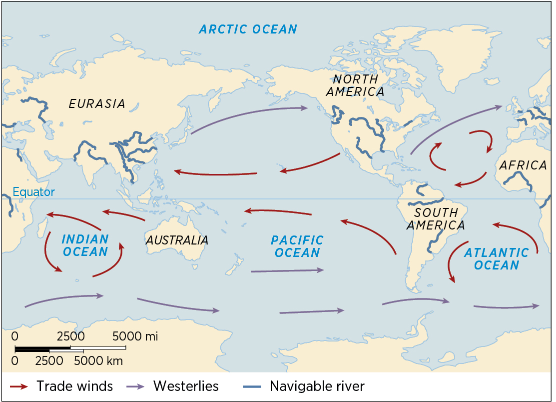
Prevailing Winds and Ocean Currents Mariners of the fifteenth and sixteenth centuries figured out the global system of winds and ocean currents, enabling them to plot the routes of sailing ships that tied the Global web together.
The ocean winds form gigantic merry-go-rounds. In the North Atlantic, for example, the prevailing winds spin in a clockwise fashion. Its westerlies (winds are named for the direction from which they blow, unlike ocean currents; so a westerly wind and an easterly current are going the same way) whip across from North America to Europe. Further south, the trade winds blow along the northwestern coasts of Africa and then whistle across to the Caribbean. In the South Atlantic, the merry-go-round spins counterclockwise, so the westerlies lie far to the south and the trade winds cross from Angola to Brazil. The North and South Pacific have their own spinning wheels, as does the southern Indian Ocean. (The winds of the northern part of the Indian Ocean are governed by the monsoon.) The whole system slides north by a few hundred miles from April to August and slips back south from September to March. Thus there is a general pattern to the world’s winds. But nobody knew that in 1400.
THE MING VOYAGES, 1405–1433
In 1400, the biggest ships and perhaps the best navigators were Chinese. Under the Song, the Yuan, and then the Ming (1368–1644) dynasties, the Chinese had rapidly developed ship and navigation technology, and Chinese merchants had taken a large role in the booming trade between East and Southeast Asia. The Ming maintained a state shipyard that employed between 20,000 and 30,000 workers. Their ships were by far the biggest in the world, capable of carrying a thousand people. Chinese tinkerers had invented the compass, and Chinese sailors used it more than sailors elsewhere. Their maritime culture was developing rapidly, thanks to constant voyaging to the islands of Southeast Asia, to Japan, and to every coast in between. By 1400, that maritime culture and Ming finances had reached a point at which they could support large, expensive, showy voyages to overawe just about everyone from Vietnam to East Africa.
Two crucial components of that maturing maritime culture were ship design and navigational tools. Chinese mariners had long used sternpost rudders and double-hulled construction. Rudders improved the steering of ships, and double hulls saved them from sinking if rammed or smashed on rocks. Chinese sailors also used the space between hulls to carry fresh water. During the Song dynasty, their seaborne trade links to the Indian Ocean acquainted them with new rigging and sails—particularly the lateen sail common in Arab shipping, good for sailing into the wind. Shipbuilders used these features, old and new, to design seagoing ships of 2,500 tons. They also put small cannon on these huge ships. As for navigation, Chinese sailors were already using the compass and printed sea manuals with star charts during the Song dynasty. A new emperor soon put Chinese maritime culture to new uses.
In 1402, a crafty uncle organized a military rebellion, overthrowing his nephew and becoming emperor of Ming China. Like all Chinese emperors, he took a reign name upon ascending the throne: the Yongle Emperor. To help consolidate his position, he promoted loyal eunuchs into positions of power. Eunuchs had minimal family connections of their own and therefore depended entirely on the emperor, making them highly reliable administrators. One of these eunuchs, Zheng He, became Yongle’s indispensable adviser and political fixer. Ruling with an iron fist, Yongle moved the capital from the south to Beijing, launched campaigns against the Mongols (in which Zheng He distinguished himself), invaded and annexed part of Vietnam, and chased down and executed everyone loyal to his nephew.
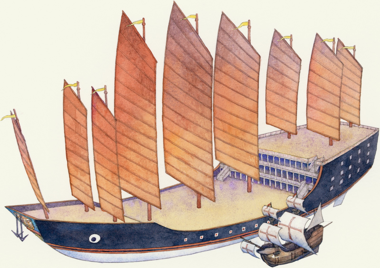
Yongle also made his devoted aide Zheng He an admiral. Even though he had probably never smelled the sea, Zheng He organized a massive maritime expedition the likes of which China—and the world—had never seen. His official errand was to find and capture Yongle’s nephew, who according to rumor had escaped his uncle’s extermination campaign. But the scale of the undertaking indicates that Yongle had additional motives. In 1405, Zheng He set sail from Suzhou with roughly 300 ships, newly built in the shipyards of Nanjing along the Yangzi. They carried 28,000 men, both sailors and soldiers, a crew larger than the population of any city they would visit. His biggest ships, if we can believe the Chinese sources, were gigantic, about 400 feet (125 m) by 160 feet (50 m) and displacing 20,000 tons—far larger than any yet built anywhere and 10 times the size of Columbus’s flagship. They were the largest wooden ships ever built.
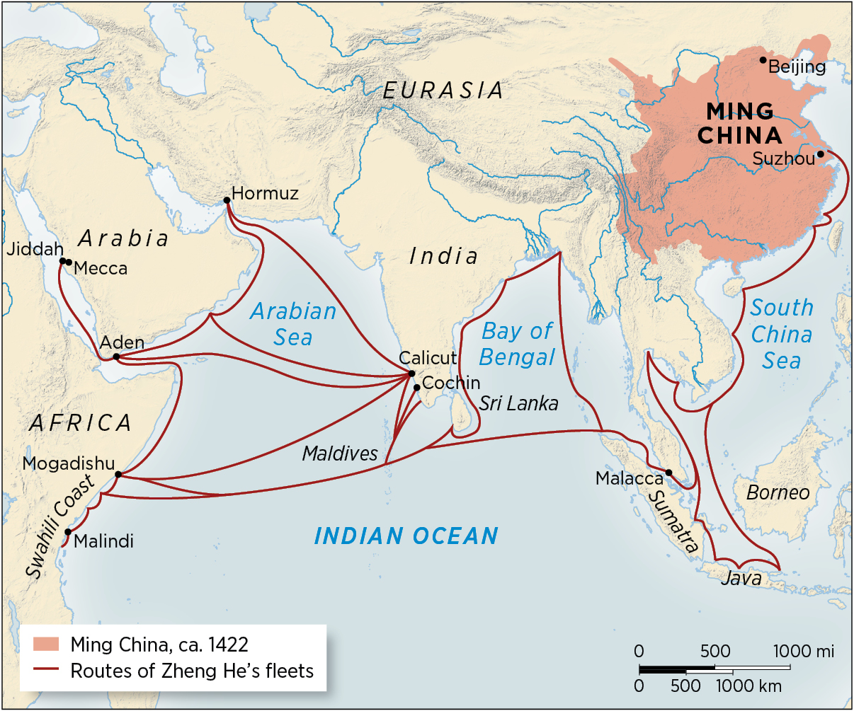
Ming Voyages As this artist’s impression illustrates, the largest ships in Zheng He’s fleet were 10 times the size of Columbus’s flagship. The size of Ming ships was symbolic, enabling the emperor to advertise his power widely.Voyages of Zheng He, 1405–1433 The Chinese admiral Zheng He led seven massive fleets into the Indian Ocean, following routes long familiar to merchants in these waters. Zheng He and his captains knew how to ride the monsoon winds, navigate with star charts, and find safe harbors. His routes extended to the far edges of the Indian Ocean world, the Swahili coast, the Arabian Peninsula, Java, and his home, China.
Zheng He sailed well-traveled seas from China into the Indian Ocean. He used persuasion, intimidation, and military power to oust unfriendly rulers in Sumatra, Sri Lanka, and elsewhere, and install replacements more willing to acknowledge Yongle’s overlordship and pay him tribute. In Sri Lanka he deposited a giant stone slab with inscriptions in Chinese, Persian, and Tamíl (a South Asian language in use in Sri Lanka after 1000 CE) commemorating his visit as an emissary of “the supreme overlord of kings”—lest anyone fail to appreciate Yongle’s stature. Zheng He annihilated pirates—or maybe just merchant princes who failed to show proper enthusiasm for the emperor and so earned the title “pirate” in Chinese accounts. Perhaps Zheng He was also looking for allies against steppe nomads, almost always the Ming’s main enemies.
Whatever his purposes, Zheng He was not attempting to find new routes. On his first six expeditions (1405–1424) he commanded similar-sized fleets, and on more than one occasion he sailed as far as the Swahili coast of Kenya. But in every case he visited ports and coasts well known to the maritime merchants of the Indian Ocean world, places where the occasional Chinese trader, and certainly Chinese goods, were familiar.
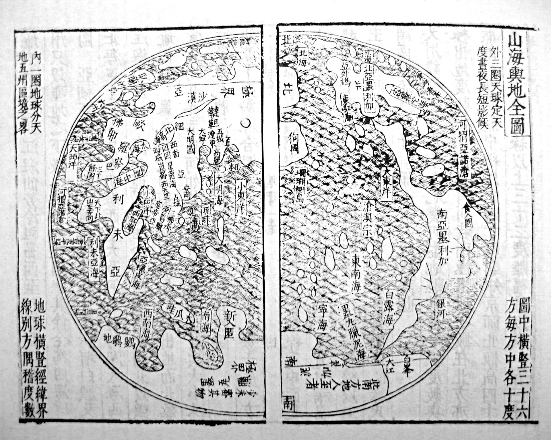
Chinese Geographical Knowledge This map made by the cartographer Wang Qi in 1607 indicates the extent, by then, of Chinese knowledge of the wider world. Centered on China and the Pacific Ocean, it offers a remarkably accurate depiction of Eurasia, Africa, the Americas, and Antarctica.
It was a traditional priority of Chinese statecraft to defend the empire’s landward frontiers. Yongle mounted and personally led many expeditions into the Mongolian steppe and sent several embassies to Central Asia trying to improve the political situation on his frontiers. Overawing distant foreigners by sea ranked well behind this priority, so the logic of doing it again and again came into question. Zheng He himself was an outsider in Chinese politics, a Muslim, a eunuch, and not even Chinese (he came from an ethnic minority population and had Persian ancestry as well). His career hinged entirely on the emperor’s favor. When Yongle died in 1424, factions came to power that did not favor overseas voyaging.
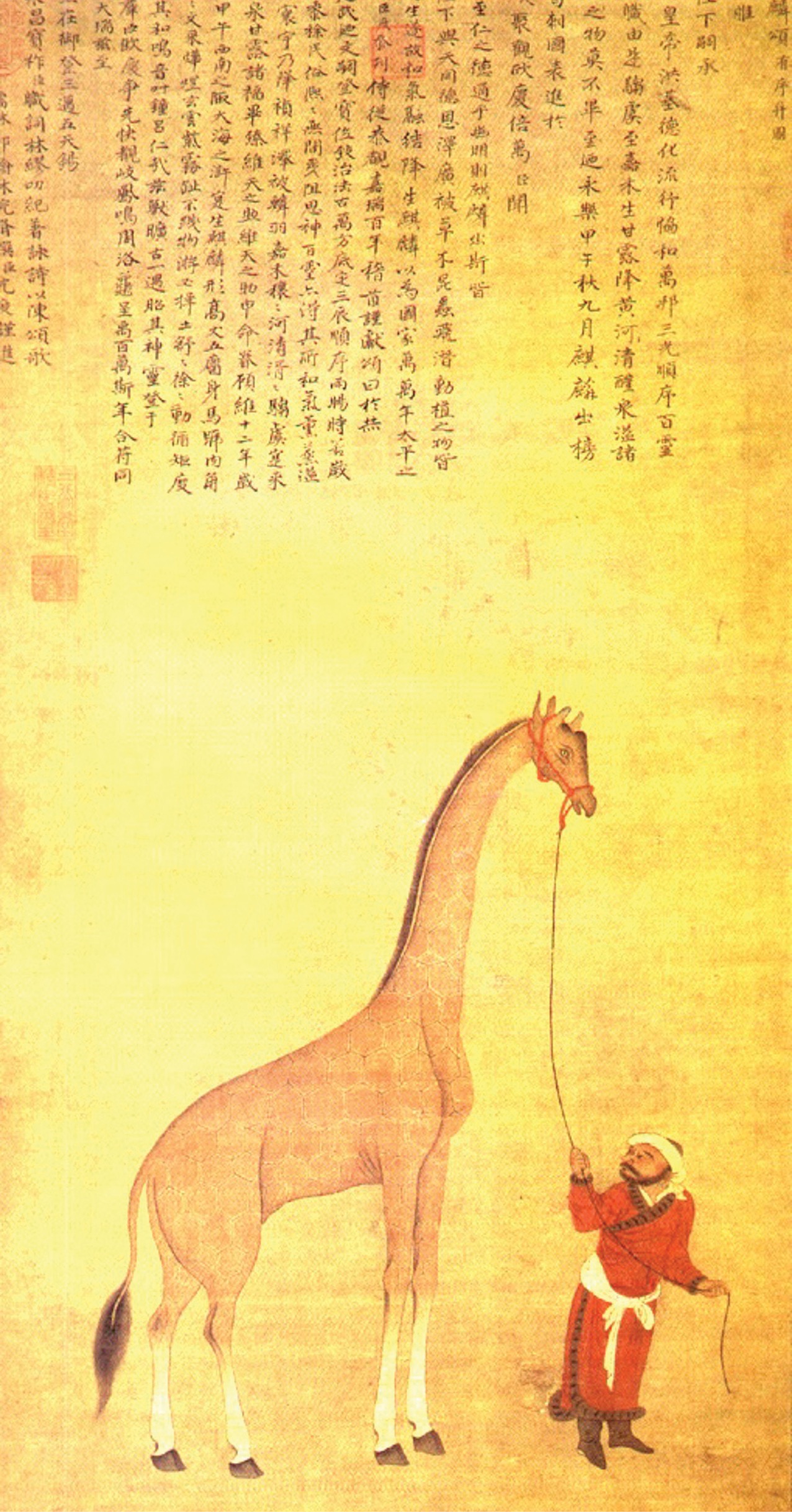
Ming Giraffe Giraffes are native to Africa, but here one appears as an illustration in a Ming manuscript, indicating the reach of Chinese maritime voyaging during the Ming period. Like other luxury goods, exotic animals could be brought back from voyages as status objects and prizes.
Those factions eventually prevailed. Voyaging was costly and did not contribute to the security or virtue of the empire, nor much to its prosperity. Repairs to the Grand Canal, finished in 1411, made seafaring less important to the Ming state and Chinese society, since shipping could flow more safely on the canal than on the sea. Yongle’s successor judged the oceanic voyaging wasteful and ended it in 1424. Under a later emperor, Zheng He and the eunuch faction prevailed one last time and launched a seventh voyage (1431–1433), again reaching Africa. But Zheng He died en route home, and his remaining supporters lost influence. The Ming eventually broke up the great fleet and sold it for fuelwood. By 1480, the skills needed to build such great ships had vanished.
The geographical and other knowledge accumulated on Zheng He’s voyages found its way into Chinese charts, maps, and books. But it did not vastly expand, or fundamentally alter, Chinese understanding of the world. It temporarily lubricated the wheels of commerce that connected China to the Indian Ocean trading ports, but only for a few decades. The Ming voyages left scant enduring legacy.
The scale of the Ming maritime effort before 1433 suggests that the Chinese had the ships and skills to sail around Africa to Europe, or south to Australia, or across the Pacific to the Americas. But they had no good reason to try to reach Europe. They didn’t yet know Australia or the Americas existed. So, instead, they sailed familiar waters in grand style with enormous government support. Then, in 1433, they stopped.
EUROPEAN VOYAGING, 1400–1700
At the same time that the Ming were gliding into the Indian Ocean, western Europeans were probing the Atlantic. Some of them dreamed of sailing to the Indian Ocean too. They lacked the massive state support that Zheng He had enjoyed, and the states that helped them could mobilize only a tiny fraction of the resources the Ming could. These mariners were lucky if they could cobble together a tiny flotilla.
But European mariners usually had a good idea where they were heading. Navigational skill had accumulated slowly but surely over the centuries in Atlantic Europe. In Iberia especially, the practical experience of sailors combined with Arab mathematics and astronomy to create a more reliable—if by no means fully reliable—art of navigation. European sailors used the compass by the thirteenth century to find direction on cloudy days. By the fourteenth, they had translated Arabic texts on the use of astrolabes to help determine latitude. Soon they were authoring their own manuals on astrolabes—the English writer Geoffrey Chaucer penned one—and building the devices themselves. But even perfect navigational skill would have meant little without seaworthy ships.
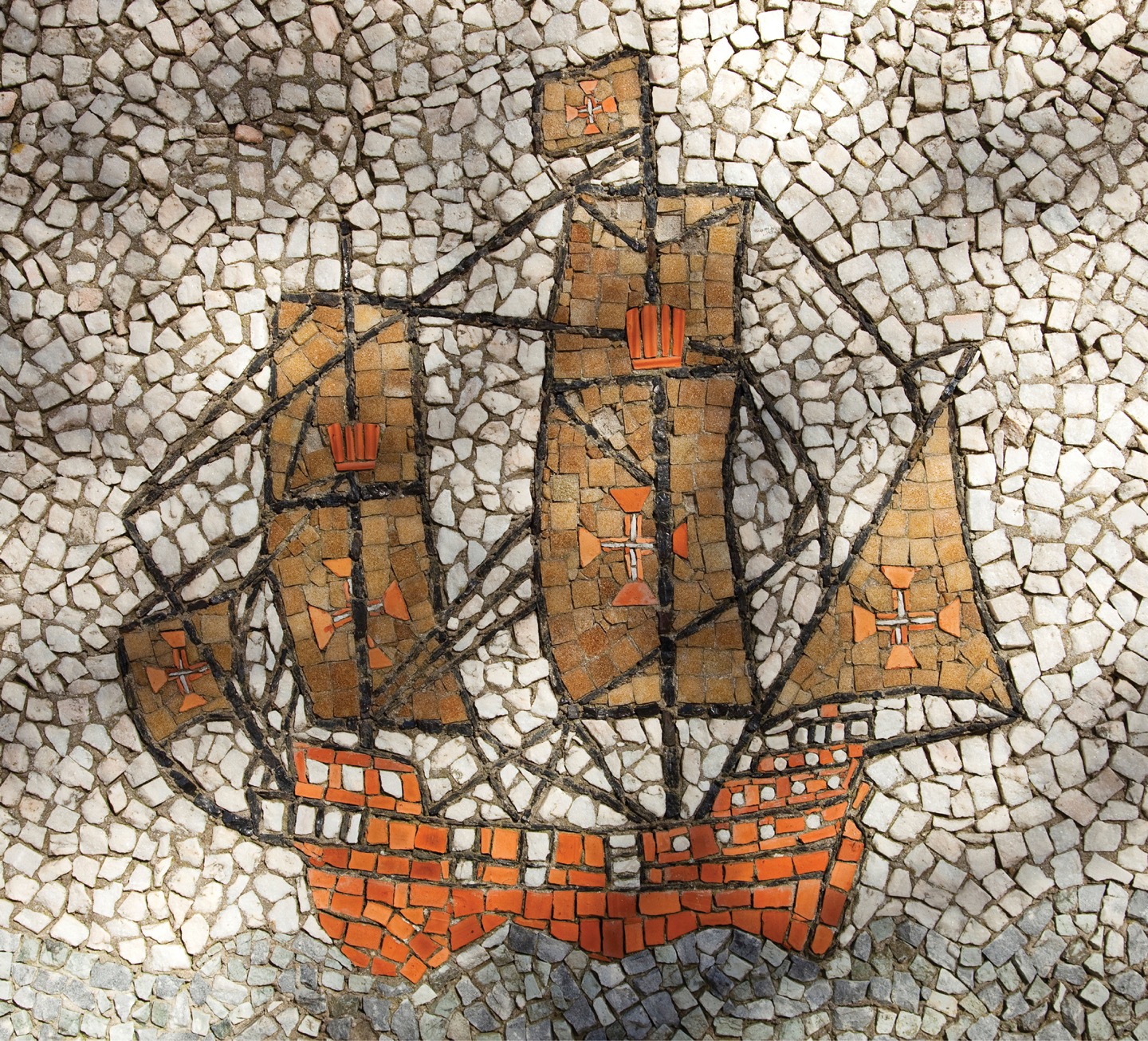
Portuguese Caravel Caravels like this one were the relatively small sailing ships used by Portuguese and other European explorers on long-distance voyages. This mosaic appears near a sixteenth-century villa outside Lisbon, the Portuguese capital.
Like the Chinese, Atlantic Europeans for a century or more had been rapidly refining their ship designs. More frequent connections in the fourteenth and fifteenth centuries between sailors in the North Atlantic and the Mediterranean yielded a hybrid in hull design and rigging. Shipbuilders combined the economical hull structure typical of Mediterranean ships—in which planks were nailed to ribs rather than to one another—with the sternpost rudder invented in the Baltic. This led to stronger, cheaper, and more maneuverable vessels. In addition, mariners supplemented square sails typical of northern waters with lateen sails characteristic of Arab seas to create the so-called fully rigged ship, which could sail swiftly before the wind and tack close to the wind. With these advances, European sailors could dispense with oars and oarsmen and rely entirely on the wind. Ships became cheaper to operate because much less was needed in the way of food, water, and wages to mount a voyage. So by the early fifteenth century, European shipwrights knew how to make sturdy, swift, and cheap ships, capable of carrying lightweight cannon and sailing anywhere in the world even in heavy weather. Their ships were far smaller than those of Zheng He, but no less seaworthy. And by 1500, they built ships large enough to carry heavy cannon capable of battering down walls or sinking any ship afloat.
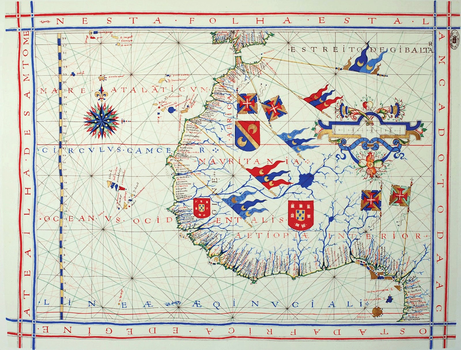
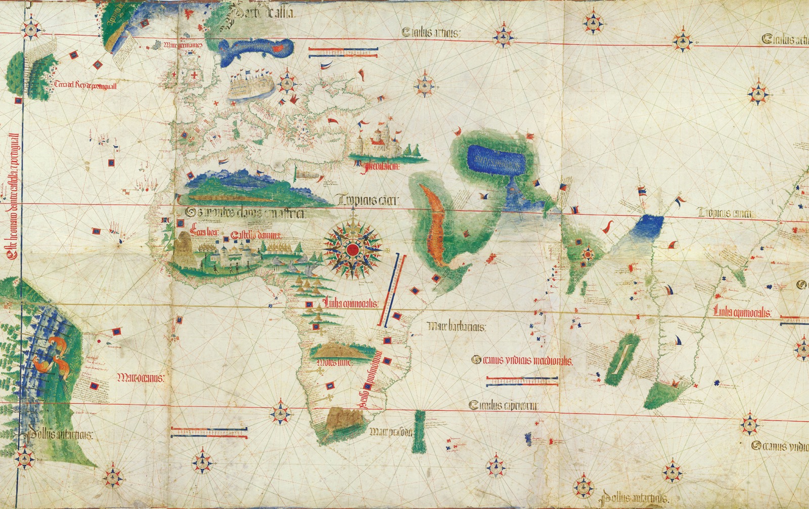
Portolan Charts This innovation in cartography helped explorers to navigate the routes between ports. A 1571 Portolan chart of West Africa shows numerous ports along the coastline, with crests indicating the powers—especially Portugal, the red and white shield—that controlled them.
Atlantic European mariners also had incentives to gamble on sailing the open seas. They, rather than the Chinese, began to unlock the secrets of the world’s winds. And once they started, unlike the Ming they did not stop.
EUROPEAN MARINERS’ MOTIVES Atlantic Europeans launched onto the high seas primarily in quest of wealth, fame, and the greater glory of their God. They started by sailing south into unfamiliar waters, looking for a practical route to African gold or Asian spices and silks, the most valuable trade goods they knew of. Merchants from Italian city-states such as Venice and Genoa had tapped into these trades, acquiring gold in Morocco or Tunisia and spices in Egypt or Syria, after the goods had changed hands many times. Merchants who could get these goods closer to the source could buy them for less and make a fortune by cutting out several middlemen.
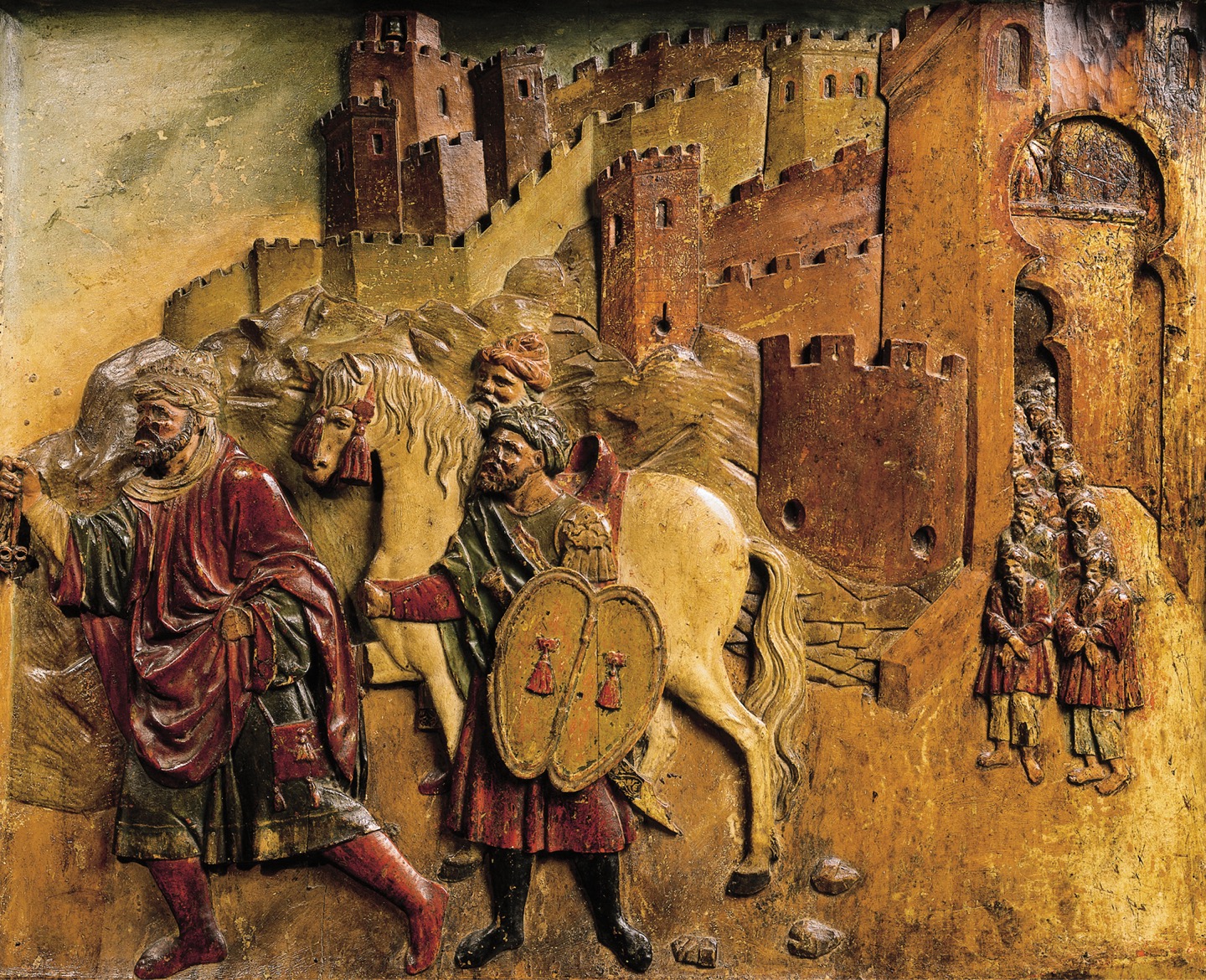
Iberian Art A wooden sculpture decorating a late-fifteenth-century altarpiece in the Cathedral of Granada shows the last Muslim king leaving Granada with his followers, after the Spanish Reconquista in 1492.
The search for glory and fame also propelled European navigators. Fifteenth-century Europeans, especially Iberians, were steeped in a culture of adventure and chivalry as proper male pursuits. Owing in part to the centuries-long Reconquista—in which Christians retook Iberia from Muslim rulers—Iberian books, songs, poems, and folk tales celebrated the deeds of heroes who took daunting risks and either triumphed or, if they died young, at least won lasting fame. Young males eager to vault several rungs up the social ladder learned that they could do so through acts of reckless heroism.
The Atlantic Europeans’ third reason for taking the risks of oceanic seafaring was simultaneously religious and political. It appealed especially to Christian rulers, for whom victories against Muslim states meant more glory, political legitimacy, and support from the Pope. European voyagers who could find Christian allies in Africa or Asia against Muslim foes might tip the balance of power in favor of Christian kingdoms. Helping to find sea routes that deprived Muslim states of their trade revenues served the same purposes. If successful, quests for Christian allies might set the stage for renewed conquest of the Holy Land, in the tradition of the Crusaders of a few centuries before. For Iberians, voyaging south along the African Atlantic coast seemed an extension of the Reconquista and the loot and glory it provided. Although the last Muslim rulers in Spain were ousted in 1492, there were more targets nearby in North Africa. Indeed, the Portuguese had already begun to attack Muslim strongholds in Morocco as early as 1415.
LEARNING THE ATLANTIC After about 1200, European and Moroccan mariners sailed hundreds of miles west into the uncharted Atlantic. By the fourteenth century, if not before, some stumbled across the Canary Islands, Madeira, and the Azores. The Canaries’ population, called the Guanches, descended from North African Berber settlers who had arrived about 1000 BCE. Madeira and the Azores were uninhabited.
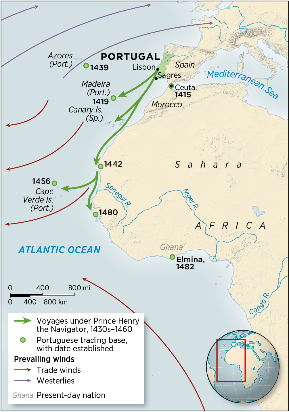
Early Exploration of the Atlantic, 1400–1480 In the fifteenth century, Iberian mariners figured out how to use the winds to venture far out into the Atlantic and get home safely. This accomplishment took navigation well beyond the familiar practice of hugging coastlines, and eventually led to successful crossings of the Atlantic and the discovery of routes linking the Atlantic and Indian Oceans.
By the early fifteenth century, Europeans were attempting settlement of these islands, which in the Canaries required Spain to undertake military conquest of the Guanches. They fought fiercely, but their long isolation meant the Guanches had never acquired metallurgy: they used only stone, bone, and wooden weapons. Moreover, with no experience of infectious diseases by now familiar to Spaniards, they suffered repeated epidemics. The conquest of the Guanches, begun in 1402, ended in 1496. Many isolated peoples around the world would soon share their fate.
Shuttling to and from these little archipelagoes helped European sailors grow accustomed to the open Atlantic. The Canaries were crucial because they served as the entrance ramp to the northeast trade winds, which would prove to be the highway to the Americas.
At the same time as they were learning about, and starting to settle, these archipelagoes, European sailors were also edging down the coast of Africa. A pair of Italian brothers, the Vivaldis, tried to circumnavigate Africa in 1291—but they were never heard from again. Others, mainly Portuguese, followed more cautiously. The northwest coast of Africa offered little fresh water, and the northeast trade winds, which made outbound journeys simple, made it hard to get back home to Portugal. Improved ship design helped with that problem, as did the gradual discovery that sailors could follow the trade winds as far south as the Canaries and then swing north to the latitude of the Azores and catch the prevailing westerlies to get home. This was the first step in deciphering the code of the oceanic wind pattern.
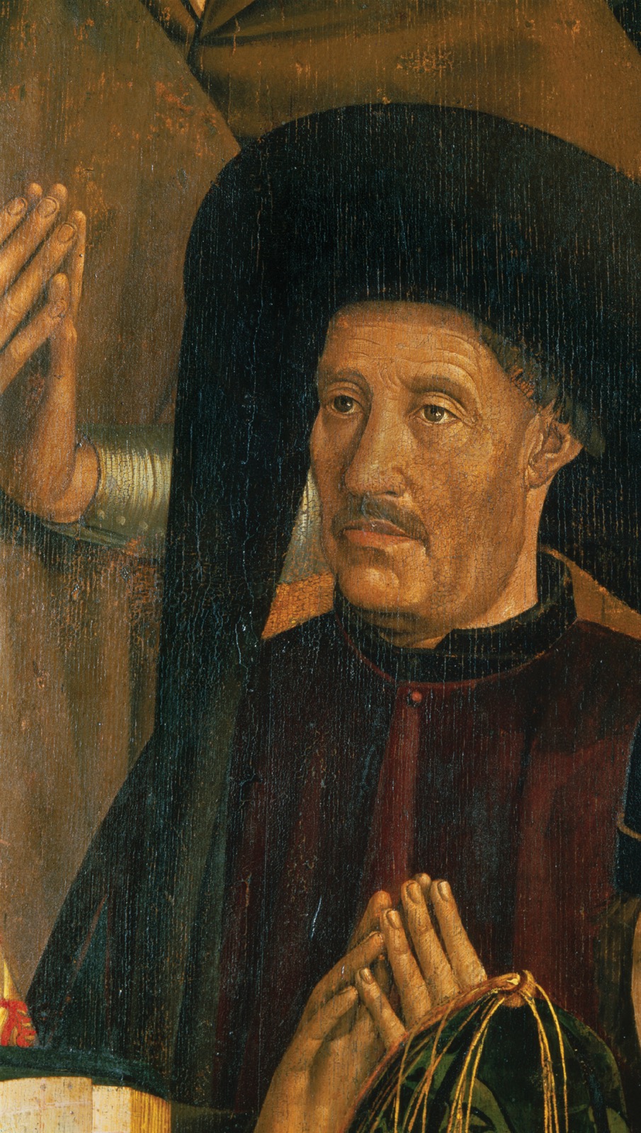
AFRICAN COASTS Portuguese efforts along the African coast quickened when in 1415 an army captured the Moroccan port of Ceuta. One of the leaders of that expedition, a prince known generously as Henry the Navigator, began to organize and support systematic voyaging along the coasts of Atlantic Africa in the 1430s. Henry was a seeker after honor and fame, which he once said were life’s highest goals after salvation. He had strong religious convictions, influenced by chivalric notions of crusades against infidels. He also took astrology to heart and interpreted it to mean he was destined for great deeds. Henry the Navigator only put to sea two or three times in his life, but he siphoned off some of the modest resources of a threadbare dynasty in a poor country to pay for sea voyages along the northwest African coast, hoping to get at the source of West African gold.
Henry the Navigator A fifteenth-century painting depicts Henry the Navigator, the prince who sponsored Portuguese voyages along the coast of northwest Africa and to Atlantic islands.
The Portuguese voyages along the northwest coasts of Africa formed part of a larger, haphazard program that was full of failures. Several Portuguese sailors tried heading west from the Azores, out into the Atlantic, but either were pushed back by the westerly winds or lost at sea. Others tried to cross the Sahara on foot, but none returned. Henry encouraged various assaults on strongholds in Morocco, most of which failed.
All these efforts were dwarfed by the simultaneous voyaging of Zheng He, who commanded far greater resources than any Portuguese sea captain ever did. The tiny size of its investment, perhaps, explains why the Portuguese Crown did not give up and put a stop to the whole enterprise, as the Ming did with Zheng He’s journeys. In any case, the Portuguese kept at it, even after Henry’s death in 1460, despite meager returns on their investment for half a century.
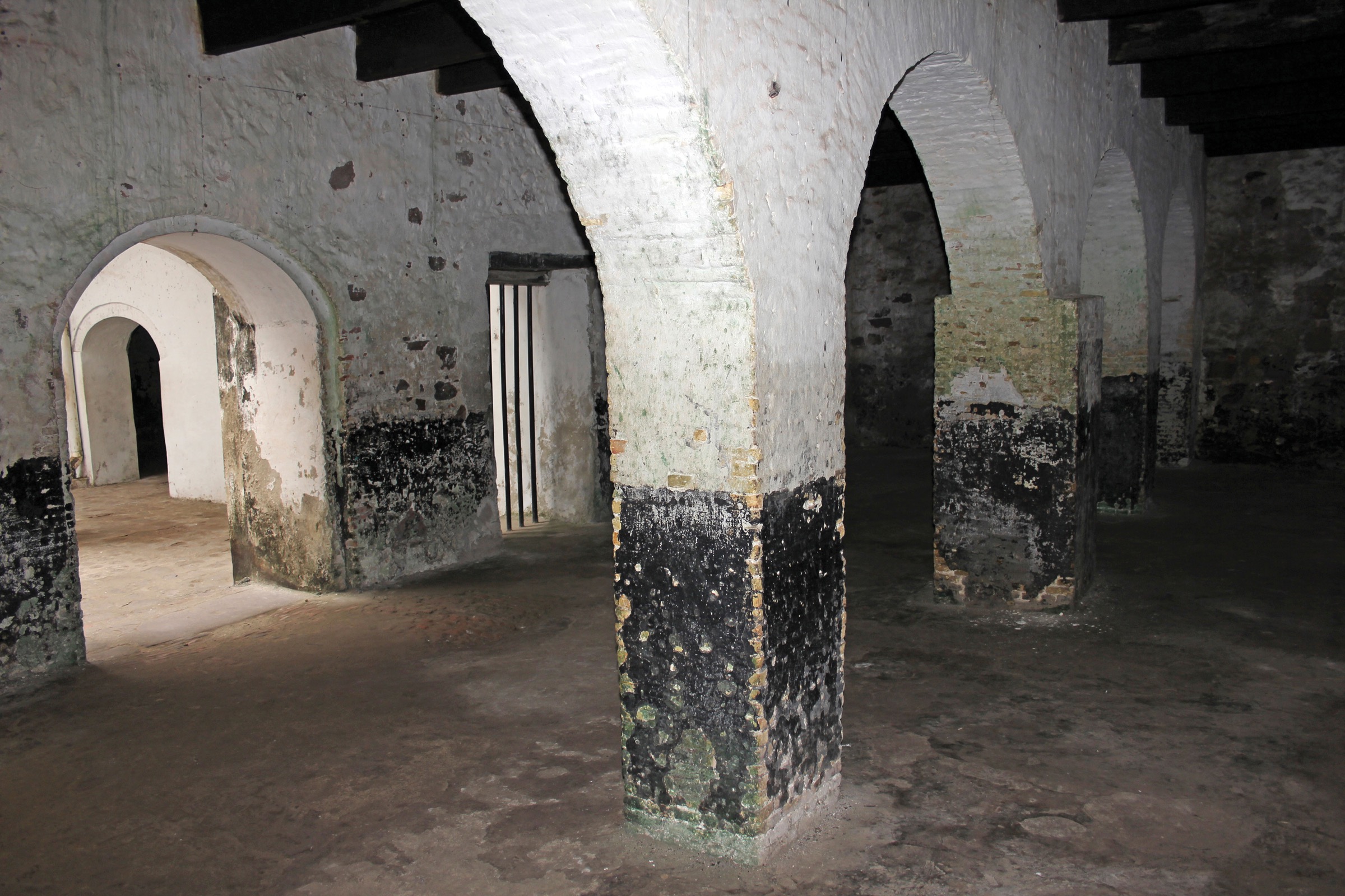
Elmina Castle The basement of the Portuguese fort of Elmina, in present-day Ghana, was originally built as a pen to hold the enslaved people who were traded on the West African coast.
By the 1480s, their efforts began to pay off. Sailors reached the West African coast of what is now Ghana and established a fort—called Elmina—through which they traded for gold. Soon they found they could buy slaves on the coast and export them from Elmina to Iberia, or the sugar plantations of the Canaries or Madeira in a lucrative supplement to the gold trade. After nearly a century of meager returns, the Portuguese monarchy now had a profitable toehold in African trade. Soon every kingdom in Atlantic Europe would be sponsoring sea captains trying to get in on African commerce. One captain would also try, as several luckless Portuguese had before, to sail to China by heading west across the Atlantic.
The Cantino Planisphere This Portuguese map was drawn by hand in 1502. Its rendering of the African coastline is especially detailed, an indication of how quickly and how well Portuguese mapmakers and navigators accumulated geographical information.
COLUMBUS CROSSES THE ATLANTIC In 1477, a ship broke up in a storm off the southern coast of Portugal. Almost everyone aboard drowned, but a 23-year-old sailor swam ashore. That sailor was Christopher Columbus.
Columbus was the son of a weaver from Genoa in northern Italy. He was a bit of a dreamer, easily lost in popular literature with its tales of adventure. He turned to the sea as a teenager, escaping the narrow horizons of an artisan’s life in Genoa. As a sailor, he first roamed the Mediterranean and then made forays into the Atlantic. He became a trader too, and sometimes made lush profits in walrus tusk, whale blubber, and other items of Atlantic trade. After he washed up in Portugal in 1477, he went to Lisbon, where he had a brother working as a mapmaker. Through his brother, Columbus began to meet people with all sorts of tall tales about what lay over the western horizon.
Columbus was working in the sugar trade, shuttling between the eastern Mediterranean and the eastern Atlantic, when in the 1480s he began to peddle schemes for a voyage further west. Sometimes he said he would find new islands, as profitable as the Canaries or Madeira. Sometimes he said he would sail to China, which he claimed was a “few days” away. He had learned of the equatorial trade winds blowing to the west from Africa’s northwest shores, and of the westerlies (blowing to the east) at higher latitudes. These prevailing winds, he figured, would allow a round-trip voyage to China. They would also allow him, the weaver’s son, to join the titled aristocracy, which seems to have been his primary ambition. Columbus was at heart a social climber, willing to take great risks in his quest for status, wealth, and glory. But to get anywhere, he needed backers.
Like any would-be entrepreneur, Columbus pitched his schemes to anyone who would listen. He failed to convince the Portuguese monarchy to invest in his plans, so he went next door to Spain, where he proved more persuasive. Funded by Italian bankers residing in Spain, he secured permission from Ferdinand and Isabella, the king and queen of Castile (the largest region of Spain), to sail under their flag. The story that Queen Isabella pawned her jewels to finance the voyage is, sadly, mere whimsy. Some of her courtiers did invest in the voyage, using funds confiscated from Jews recently expelled from Castile.
Columbus promised the investors that he would forge a route to and from China by sailing west with the trade winds and then back home with the westerlies. He figured that Japan, which he had read about in Marco Polo’s book of travels, lay about 2,500 miles (4,000 km) west of Spain. His estimate was off by about 10,000 miles. Had he calculated correctly, he surely would have stayed home.
Instead, he gathered sailors in the small Spanish port of Palos, acquired three little ships, and set out on the well-worn route to the Canary Islands. From there he ventured west into the open sea, seeing no land for 35 days before bumping into an island, perhaps Watlings Island in the Bahamas.
What he found looked nothing like Japan or China. Far from sporting silken robes, the locals stood stark naked and seemed unashamed of it. They had dugout canoes but no ships, and huts instead of palaces. Still hopeful, Columbus quickly moved on and in two weeks was in Cuba. He later stopped at the island of Hispaniola, where he met the more familiar trappings of complex society—dense populations, intensive agriculture, trade networks, and rumors of great kings. On Hispaniola, someone presented him with a few lumps of gold, something he could bring back for his investors. Upon his return home, he insisted to his backers that he had found a direct route to islands off the coast of Asia—and he probably believed it.
The Spanish Crown rewarded him with the title Admiral of the Ocean Sea and granted him broad powers to operate as he saw fit on subsequent voyages. He returned three more times to the Caribbean, even reaching the mainland shores of South and Central America. He engaged in slave trading (of Amerindians native to the Caribbean), bloody reprisals, and several sorts of atrocity in his eagerness for gold. His conduct met with rebukes among his followers and back in Spain. He hanged several Spaniards who defied his authority. A Spanish woman who reminded everyone that the Admiral of the Ocean Sea was the son of a weaver had her tongue cut out.
Columbus’s final years were filled with recriminations, lawsuits, bankruptcy, imprisonment, and bitter disappointment that he had found few riches and had not made it to China. He died in 1506, still convinced he had reached the doorstep of the Great Khan. No one else in history has had so many streets, squares, schools, and hotels named after him for making such a big mistake.
Columbus was wrong and he was brutal, but he was nonetheless a central historical figure. His voyages inaugurated a new age of connection among worlds long separate.
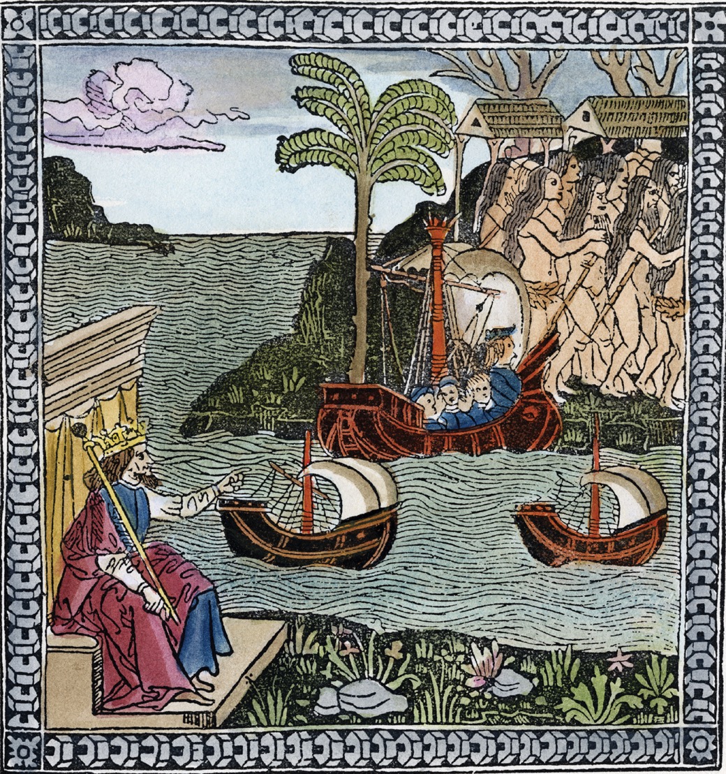
Columbus’s Landfall In this 1493 engraving from La lettera dell’isole, Columbus’s first account of his voyage, King Ferdinand observes from afar as Columbus and his crew land on an island in the Caribbean. The island’s native inhabitants appear to flee.
Soon after Columbus returned from the second of his four transatlantic voyages, another Italian, Giovani Caboto, was proposing voyages to China across the Atlantic. John Cabot, as he is known, approached merchants in Bristol, England, who were growing rich on the whale and walrus trade of the North Atlantic. Cabot also enlisted support from the English court, and in 1497 he made it across the Atlantic to Newfoundland and back in a tiny ship, about 3 percent the size of Zheng He’s flagship. His crew numbered about 18. Among the treasures Cabot reported, mostly fanciful, were the very real and stupendously rich cod fisheries off of Newfoundland. Like Columbus, he recruited more investors, fitted out more and bigger ships, and set sail across the Atlantic a second time. Unlike Columbus, he never came back. Nevertheless, from soon after Cabot’s time, Europeans would sail regularly to the fishing grounds off of Newfoundland, creating an enduring link—something the Viking voyaging to Newfoundland, some 500 years before, had not done.
DA GAMA SAILS TO INDIA In 1497, the same year that Cabot sailed, the Portuguese court fitted out an expedition of four ships and 170 men under the command of a low-ranking provincial noble named Vasco da Gama. Just a few years before, a Portuguese captain, Bartholomew Dias, had sailed from Lisbon to the shores of South Africa and returned safely. Dias discovered the belt of westerly winds in the Southern Hemisphere that enabled ships to sidestep adverse currents and ride into the Indian Ocean from the South Atlantic. Counting on this information, da Gama sailed way out into the South Atlantic to catch the westerlies and made it safely to the tip of South Africa and into the Indian Ocean. He worked his way up Africa’s southeast coast and soon found evidence, in the form of Indian cloth and glassware, that he was where he hoped to be—in the Indian Ocean.
The ultimate prize, a practical route to and from the rich trade of Asia, lay almost within da Gama’s grasp. He and his men resorted to piracy and the kidnapping of local pilots to help them find their way. On the shore of what is now Kenya they found a pilot who showed them the easiest route to Calicut, a trading city on the coast of India, where the Portuguese hoped to find—as one of da Gama’s captains put it—Christians and spices.
The Portuguese expedition under da Gama had two main goals. The Portuguese Crown hoped to win glory, papal favor, and some practical political advantage by finding Christian allies somewhere in the Indian Ocean world, friends who would help in struggles against Muslim states of North Africa and Southwest Asia. The Crown also hoped to boost its finances by trading in spices, peppers, cloves, nutmeg, and more, items that were plentiful in India but scarce and expensive in Europe. Some Italian traders had done well in the spice trade, linking Venetian markets, through Egypt or Syria, with sources of supply in India and even further afield in Southeast Asia. The Portuguese hoped to help themselves to a share of this trade by sailing around Africa and going directly to the source of spices. Da Gama encountered no politically useful Christians in Calicut, but he found plenty of spice traders.
Da Gama and his crew did not linger long in India. The trade goods they had brought with them didn’t interest the merchants of Calicut. The local prince wanted da Gama to pay customs fees like any trader, whereas da Gama regarded himself as a royal emissary and above such things. After three disappointing months the Portuguese left, kidnapping a few Indians and sailing back toward Africa. Portuguese–Indian relations were off to a rocky start.
Da Gama left in a huff, pointing his prows into the teeth of the summer monsoon. The route that had taken three weeks with the winds at his back now took him four months on the return. Half the crew died before they reached Africa, and only 55 remained alive when da Gama returned to Lisbon more than two years after departing. He had sailed more than 25,000 miles (40,000 km), equal to the circumference of the Earth. He had confirmed the understanding of the winds of the South Atlantic and had pioneered a practical, if slow, route between western Europe and South Asia. And he had brought back enough spices to inspire investors, especially the Portuguese Crown, to send him back again.
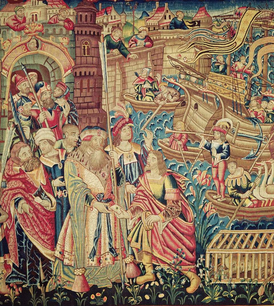
Vasco da Gama A sixteenth-century Flemish tapestry illustrates the moment of encounter between da Gama and his men and the people of the Indian trading port of Calicut—which actually looked much less like a European fortified city than this artist imagined.
In subsequent voyages, da Gama helped set up a lasting Portuguese presence in India and East Africa. It consisted of small trading enclaves, always fortified, sometimes under the protection of local rulers and sometimes at odds with them. The rivalries among rulers on the Indian and African coasts ensured that da Gama, and later Portuguese as well, could always find allies. Da Gama committed remarkable acts of cruelty, especially against Muslims making the pilgrimage to Mecca. He understood his mission to include piracy against Muslim shipping and did not mind making enemies. (He was not beloved by his own men either—at least, not after he ordered them to rinse their mouths with their own urine to combat scurvy, a gum disease resulting from vitamin shortage, one that often beset sailors on long voyages.)
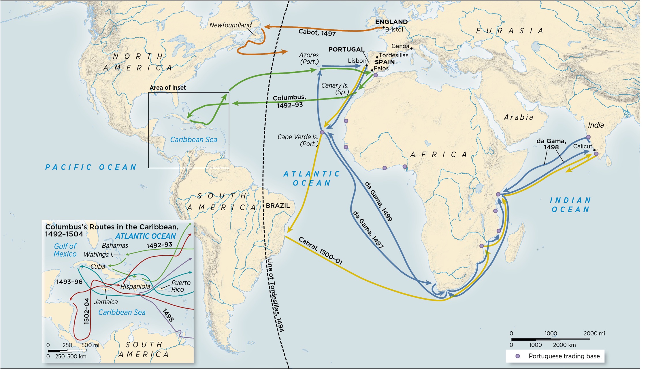
Navigation in the Atlantic and Indian Oceans, 1492–1500 This map shows the new routes pioneered by Columbus, Cabot, da Gama, and Cabral, which began the process of tying together the coasts of Europe, the Americas, Africa, and South Asia. The Line of Tordesillas, established in 1494, divided all “new” lands between Portugal and Spain.
The Portuguese commercial presence did not matter much to Indians and Africans, who continued their business much as before. But to Portugal, a poor kingdom of fewer than a million people, the occasional trading voyage to India meant infusions of riches, especially for the Crown. The trade to the Indian Ocean also affected Portuguese culture and self-image. Portuguese monumental architecture developed a distinctive style, called Manueline after Manuel I (r. 1495–1521), the king at the time of the first voyages to the Indian Ocean. It celebrates those voyages and nautical life, using artistic motifs from sailing ships and from Indian temples and mosques. The Portuguese national saga, known as The Lusiads, is an epic poem, first printed in 1572. It is modeled on ancient epics, especially the Iliad, but based loosely on the experience of da Gama and other sea captains.
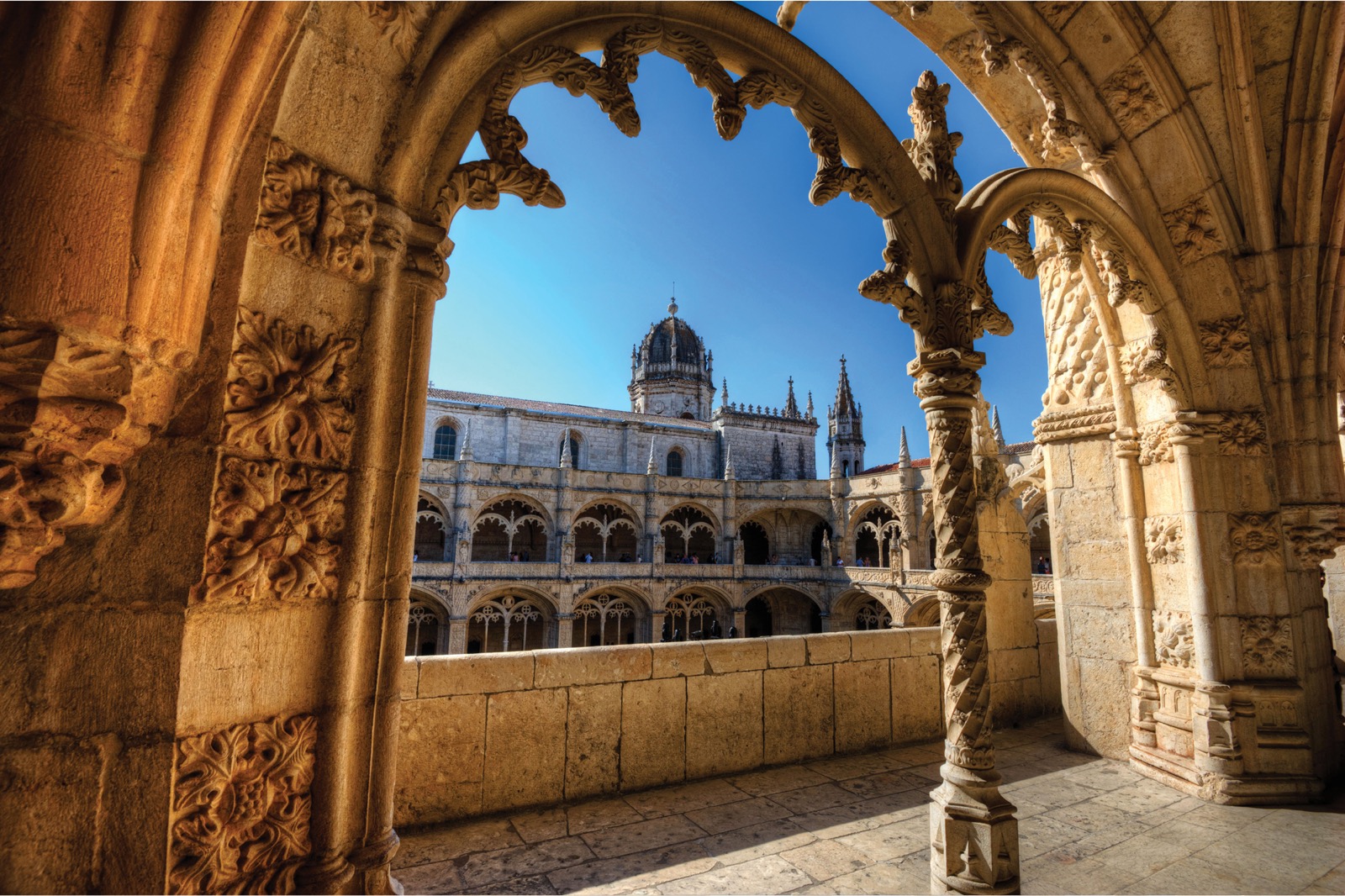
Manueline Architecture The Jerónimos Monastery in Lisbon, on which construction began in 1501, is a characteristic example of Manueline architecture. The braided pattern encircling the midsection of the column at the center of this double arch is intended to evoke ships’ ropes.
One of the voyages to India missed its target. In 1500, on his swing out into the Atlantic in search of the Southern Hemisphere’s westerlies, Pedro de Cabral and his fleet of 13 ships accidentally bumped into Brazil. Cabral claimed it for Portugal, despite the fact that people already lived there. After a brief look around, he continued on across the South Atlantic, around Africa, to India. Like da Gama, he ran into trouble in India with Arab merchants unhappy with competition and engaged in a vengeful massacre in Calicut before heading home in 1501.
Sailors such as Columbus, da Gama, and Cabral made the years 1492–1501 as pivotal as any decade in world history. Mariners from Atlantic Europe learned how to ride the winds back and forth between Europe and America, between Africa and America, and between Europe and South Asia. They found viable routes across the open ocean linking coastlines of continents formerly out of touch with one another.
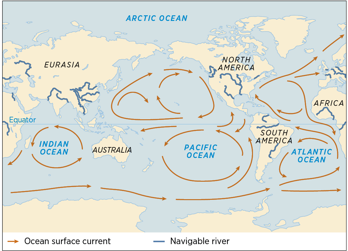
The discovery of the oceans did not stop in the 1490s. Mariners had now solved the mysteries of the wind system of the Atlantic, as they had long ago the monsoon winds of the Indian Ocean. But the broad Pacific was another matter. Its winds and currents were even more essential to master, because the Pacific is so big that sailing against the wind is a sure way to die at sea of thirst or hunger. No one had much reason to cross the Pacific—until the beginning of the sixteenth century.
MAGELLAN CROSSES THE PACIFIC At the end of the fifteenth century, Spain and Portugal signed what could be the most presumptuous treaty of all time, the Treaty of Tordesillas (1494). It drew a line halfway between the American lands Columbus had visited and Portuguese territories known as the Cape Verde Islands off the West African coast. Spain claimed all new lands (meaning new to Spaniards) west of the line, and Portugal all new lands to the east.
With the Treaty of Tordesillas in place, once Portuguese vessels were trading on the Indian Ocean, Spain acquired a motive for trying to cross the Pacific: to gain direct access to precious spices. No one knew how big the Pacific was, and many thought the distance from America to the East Indies—the islands of Indonesia where by 1515 Portuguese merchants were buying spices directly—could not be far. The Molucca Islands, in particular, where nutmeg and cloves grew, excited European imaginations as if they were diamond mines. The Treaty of Tordesillas gave Spain claim to lands west of the Americas, which, if the claim extended far enough, would include the spice islands.
A Portuguese adventurer and dreamer named Fernão de Magalhães, or Ferdinand Magellan, tried and failed to convince authorities in Lisbon that it would be easier to reach the Moluccas by finding a route south of South America and then sailing west to Asia. He imagined that if there really was an ocean to the west of the American landmass, it was a small one. No one in Portugal would listen. So, like Columbus before him, he took his idea to the Spanish court. Eager to claim the Moluccas and their spices, the Spanish Crown encouraged bankers to invest in Magellan’s plans.
So in 1519 Magellan sailed out into the Atlantic with five ships, 250 men (about 1 percent the size of Zheng He’s crew), and the most fanciful ideas of how to find the spice islands. Magellan’s crew mutinied twice before they even got to the Pacific. Then things went south in a hurry. Magellan thought he could cross from South America to the spice islands easily, but he had been on the ocean for 14 weeks, out of food and fresh water, before his men sighted Guam—they had sailed across an ocean with hundreds of inhabited islands and by bad luck had missed them all. One of the crew explained their suffering:
We only ate old biscuit reduced to powder, full of grubs and stinking from the dirt, which the rats had made on it when eating the good biscuit and we drank water that was yellow and stinking. We also ate the ox hides which were under the main-yard, so that the yard should not break the rigging: they were very hard on account of the sun, rain, and wind, and we left them for four or five days in the sea, and then we put them a little on the embers, and so ate them; also the sawdust of wood, and rats which cost half-a-crown each, moreover enough of them were not to be got.
CONSIDERING THE EVIDENCE
Portuguese Reasoning about Skin Color
As Portuguese ships explored the oceans, they also recorded observations about geography and people that contradicted traditions handed down from classical scholars. The Portuguese sea captain Duarte Pacheco Pereira (1460–1533) discussed some of these contradictions in his manuscript Esmeraldo de Situ Orbis. Pereira had voyaged nearly everywhere the Portuguese reached. He defended Portuguese forts in India, governed Elmina off the coast of West Africa, and captured a French pirate in the Atlantic. He was also the first person to mention Brazil in a navigation book. In the following excerpt, he draws on personal observations to reconsider the classical Greek assumption that skin color was determined by latitude.
[D]uring the many years we have sailed and operated in this part of the Ethiopias of Guinea [i.e., West Africa], experience has taught us how to take the height of the sun and its declination in order to tell the degrees of latitude by which each place is separated from the Equator and one of the poles. And we have found that this promontory lies directly over the Equator, and have discovered that in this place the days and nights throughout the year are equal....
Many of the ancients said that if two lands lie to the east and west of one another, both would have the same degree of sun and would be in all things alike. As to their equal share of the sun this is true, but such is the great variety employed by the majesty of nature in her work of creation and procreation that we find, from experience, that the inhabitants of this promontory of Lopo Gonçalves and of the rest of Guinea are very black, whereas the people who live beyond the Ocean Sea to the west (who have an equal amount of sun with the blacks of Guinea) are brown, and some almost white. These are the people who live in the land of Brazil....If any want to claim that these are protected from the heat of the sun because there are many trees in that region, I would say that there are also many trees as great and as thick in this land of Guinea on the eastern side of the ocean. And if any should say that they are black because they go around naked and that the others are white because they go clothed, I would say that both of them...go around just as they were born. So we can say that the sun does not affect one more than the others. Now it only remains to find out if they are both descended from Adam.
Source: “Duarte Pacheco Pereira Tries to Come to Terms with ‘Difference,’” in Malyn Newitt, ed., The Portuguese in West Africa, 1415–1670: A Documentary History (Cambridge, 2010).
QUESTIONS FOR ANALYSIS
What evidence does Pereira rely on to challenge the conclusions of “the ancients”?
After dismissing possible explanations for the differences in skin color between people in Africa and those in Brazil, what direction does he suggest for future research?
Does this excerpt suggest that the Portuguese of Pereira’s time considered people whose skin color differed from theirs to be inferior in any way?
On Guam, Magellan guessed he was just off the shore of China. He was 2,500 miles (4,000 km) from it. He next blundered into the Philippines, where he got mixed up in a local war and died in battle.
Magellan’s surviving crew kept going west, sailing through the islands of Indonesia, where they picked up a cargo of spices, and into the Indian Ocean, around Africa, and home to Spain. The trip had taken three years, and only about 10 percent of the crew survived. They were the first humans to circumnavigate the globe—although they had intended only to find a route to the Moluccas and spices.
It took many decades before anything practical came of Magellan’s quixotic quest. Magellan had showed how big the Pacific really was, and that it—like the Atlantic—had trade winds blowing east to west. Some 40 years later, another captain showed how one could cross the Pacific west to east, from Asia to America, by riding the westerlies, found at the same latitudes as those of the Atlantic. By 1570, Atlantic Europeans had deciphered the wind system of the Pacific too.
WEAVING A MARITIME WEB
Every coastline in the world was now more accessible than ever before to those who knew the secrets of the winds. While Magellan sailed the wide Pacific, other mariners in less dramatic fashion brought more of the world into a tighter web of connections. Portuguese captains began to visit China and Japan, following routes that Asian sailors had used for centuries. From the East African coast, Portuguese adventurers pushed inland, developing a previously small-scale trade in slaves and ivory in Mozambique and making contact with fellow Christians in Ethiopia. These Portuguese travels followed the beaten paths of Asian and African traders.
While European sailors were gathering up knowledge of routes and coasts in Africa and Asia, as far as Australia and Japan, others were adding further information from the Americas. Columbus had begun the process, but dozens of others, mainly Spaniards, followed. They sailed the coastlines, probed the river mouths, and, despite language barriers, absorbed what they could from Amerindian informants. By 1520, they had accumulated a good knowledge of the Caribbean and South America coasts. It took much longer for mariners to figure out the coasts of North America, but by 1620 sailors, mainly English and Dutch, had charted the eastern shoreline all the way north to the fogbound and iceberg-strewn coasts of Hudson Bay. To their dismay, they established that here too there was no good route to the riches of Asia. That dream died hard. As late as the 1630s, Jean Nicolet, a French fur trader, walked and canoed through Wisconsin wearing flowing Chinese robes in hopes of meeting someone who knew the way to China.
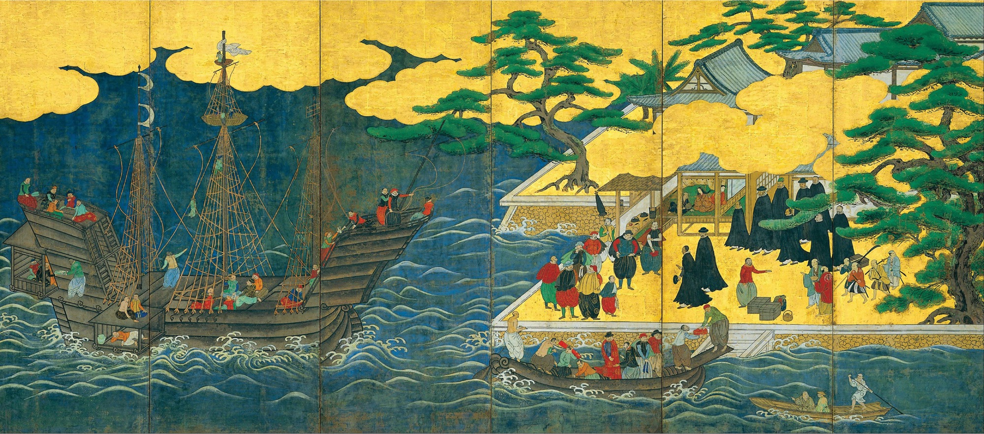
Namban Screen This six-fold Japanese screen from around 1600 likely illustrates the arrival of a Portuguese merchant ship in Japan. Portuguese sea captains began to visit Japan in 1543, bringing Christianity, guns, and Chinese silks and porcelain. They bought thousands of Japanese slaves to sell in Macao, Goa, or other Portuguese enclaves until the trade ended soon after 1600.
Gradually, mariners filled in the remaining blank spots on the map of the oceans. Dutch and English ship captains sailed around New Zealand and Australia in the seventeenth century, charting the coasts. But finding the Maori unwelcoming and the Aborigines poor, they left these lands alone for another 150 years. In the eighteenth century, European sailors refined their knowledge of Pacific shores and blundered into most of the inhabited Pacific islands, including the remotest outposts of Polynesia in Easter Island and Hawaii. They charted the American coastlines from Alaska to Chile. By 1780, every significant coast of every ocean had been mapped, and every important island located. For all intents and purposes, the discovery of the winds and the oceans was complete.
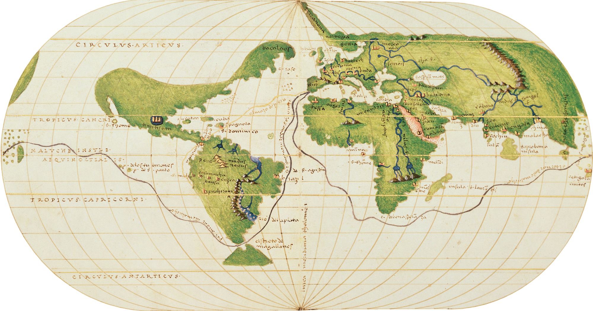
Magellan’s Circumnavigation The Genoese cartographer Battista Agnese made this map of the world in 1540, with lines illustrating the route Magellan took across the Pacific and the Indian Ocean. The extent of Portuguese and other European navigation enabled Agnese to produce detailed renderings of the world’s coastlines.
European mariners failed in their quest to find a direct route from Europe to Asian spices and failed to find powerful Christian allies against Islamic polities. But they succeeded at something they did not consciously attempt, which was to unite the world’s coasts and harbors into a single network and to build geographical knowledge so that any competent navigator, with the right equipment and ship, could go anywhere on the sea with a reasonably good idea of where he was and what lay ahead. The confidence with which merchants had long sailed the South China Sea, the Arabian Gulf, or the Mediterranean, European merchants (and for a long while only European ones) now extended to the deep oceans. The first pulse of true globalization, achieved partly by accident, was accomplished mainly by Europeans—specifically, those from Atlantic Europe.
Seven large maritime voyages arranged by Zheng He under the Yongle Emperor of China during the Ming dynasty. The extent of the voyages and the size of their wooden ships were unprecedented, and they served to project power as far as East Africa.
A centuries-long Christian campaign to retake Iberia from Muslim rulers. Europeans, especially Iberians, viewed sailing expeditions as a way to continue the Reconquista in new lands by spreading Christianity and depriving Muslim states of wealth from trade.
Descendants of North African Berbers, the Guanches were inhabitants of the Canary Islands who fought against Spanish conquest and settlement from 1402 to 1496. Spanish weapons technology and the diseases they carried with them eventually led to the defeat of the Guanches.
Born in Genoa, Italy, Christopher Columbus secured funding from the king and queen of Castile (a powerful state in Spain) to sail west from Europe and find a route to China in 1492. He instead found islands in the Caribbean and inaugurated a new age of global interconnection.
A low-ranking Portuguese noble who led an expedition in 1497 around the southern tip of Africa and into the Indian Ocean in search of Christian allies and valuable spices for the Portuguese Crown. He helped set up a lasting Portuguese presence in India and East Africa.
An important commercial port city on the southwest coast of India. Its merchants traded various spices that were highly sought by Arab, Persian, and European merchants.
Spain and Portugal used this agreement to demarcate a line halfway between Columbus’s discoveries in the Americas and the Cape Verde islands off the coast of West Africa. It gave all lands west of the line to Spain and all lands east to Portugal.
A Portuguese explorer whom the Spanish Crown funded to find a route to the Moluccas by sailing west from Europe and along the southern coast of South America in 1519. He died in the Philippines after crossing the Pacific, but his crew became the first people to sail around the world and attained knowledge of the vastness of the Pacific Ocean.
Part of the islands of Indonesia, also known as the East Indies, where nutmeg and cloves grew. Because Europeans placed great value on these spices, trade connections to these islands were very attractive to merchants.