The Yellow and Yangzi River Basins: East Asia
Like the Mesopotamians, Egyptians, and Harappans, East Asian peoples clustered in river basins. Their settlements along the Yellow River in the north and the Yangzi River to the south became the foundation of the future Chinese state. By 5000 BCE, both millet in the north and rice in the south were under widespread cultivation.
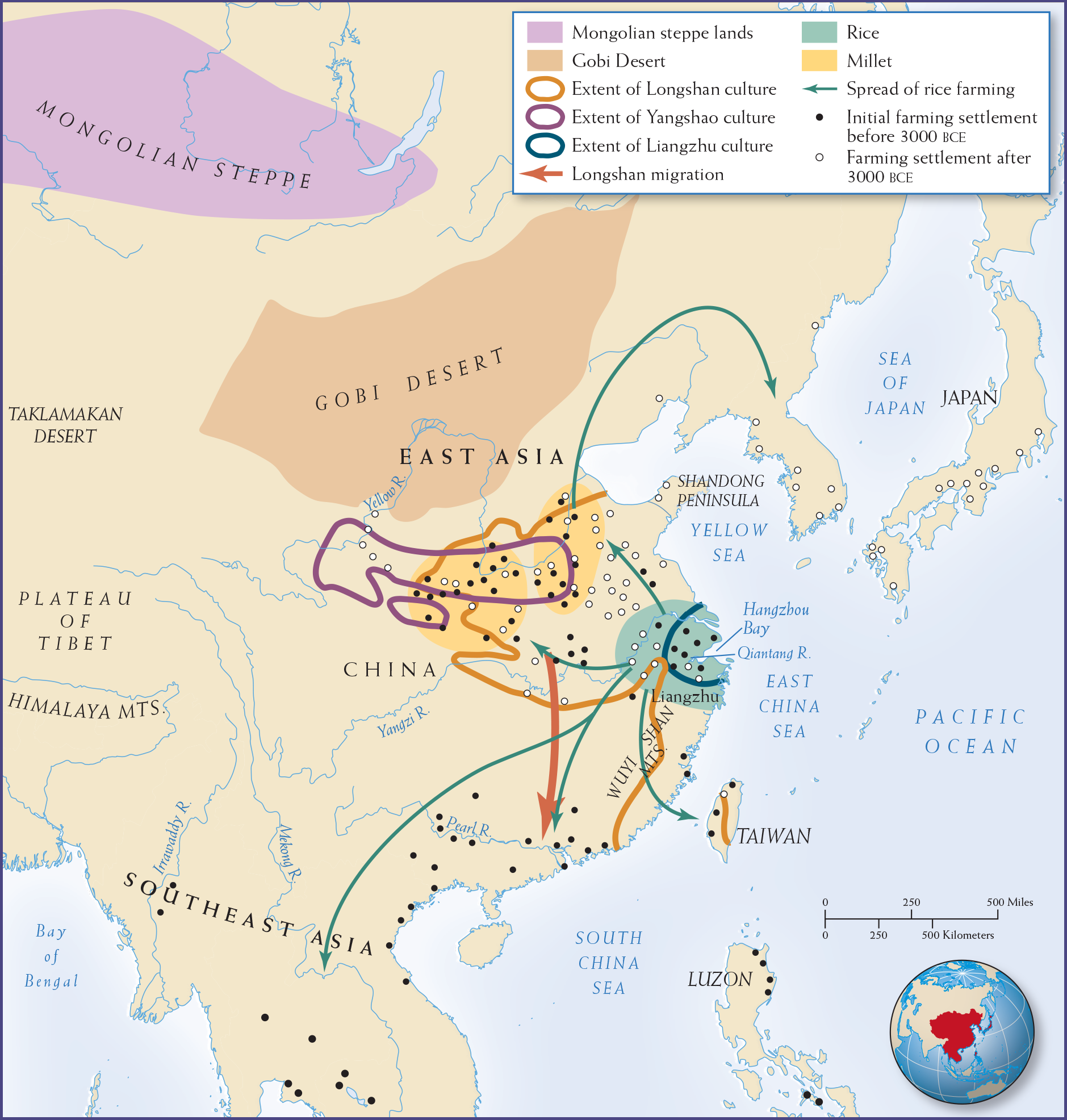
Yet in the following three millennia (when Mesopotamia, Egypt, and the Indus Valley were creating complex, city-based cultures), the Chinese moved slowly toward urbanization. (See Map 2.6.) Like the other regions’ waterways, the Yellow and Yangzi Rivers had annual floods and extensive floodplains suitable for producing high agricultural yields and supporting dense populations. In China, however, the evolution of hydraulic works, big cities, priestly and bureaucratic classes, and a new writing system took longer. A lack of easily domesticated animals and plants contributed to the different developmental path in China, as did geographic barriers. The Himalaya Mountains and the Taklamakan and Gobi Deserts prevented large-scale migrations between East Asia and central Asia and hindered the diffusion of cultural breakthroughs occurring elsewhere in Afro-Eurasia.
From Yangshao to Longshan Culture
China’s classical histories have claimed that China’s cultural traditions originated in the Central Plains of the Yellow River basin and spread outward to less developed regions inside and even beyond mainland China. These histories place the beginnings of Chinese culture at the Xia dynasty, dating from 2200 BCE. Archaeological studies of river-basin environments in East Asia tell a different story, however. Whether or not the Xia existed as a historical dynasty, archaeological evidence suggests our study of the Yellow River basin and Yangzi delta should begin earlier—in the two millennia from 4000 to 2000 BCE.
China in 4000 BCE was very different geographically and culturally from what it is today. A warmer and moister climate divided its vast landmass into distinctive regions. Only after a long cycle of cooler and drier weather did these bodies of water dry up and the landmass become a single geographical unit. Recent archaeological research records that at least eight distinct regional cultures appeared between 4000 and 2000 BCE, and only as these communities interacted did their institutions and ways of life come together to create a unified Chinese culture.
Yet China was a land apart in the Afro-Eurasian landmass, isolated by the mountains of the Tibetan plateau in the west, the deserts of Inner Mongolia in the north, the tropical rain forests in the south, and the ocean in the east. China had only two difficult natural routes to the rest of Asia and Europe. One route led into central Asia by the narrow Gansu Corridor, running between the Qilian Mountains on the northern edge of the Tibetan plateau and the Gobi Desert. The other ran along a narrow band of the steppe north of the Yellow River and around the Gobi Desert, eventually ending up in the Mongolian steppe, the Altai Mountains, and the Kazakh steppe. Though trade with and migration into China were more limited than that which fused together Egypt, Mesopotamia, and the Indus Valley, nomadic cultures and technologies nevertheless filtered from the steppes to settled communities on the rivers.

More information
Map 2.6 is titled “River-Basin Peoples in East Asia, 5000-2000 B C E.” Two geographic features are shown: the Mongolian Steppe lands on the map’s northern edge, and the Gobi Desert is south of it and extends to the Yellow River. Areas of initial rice cultivation are shown north of Liangzhu where the Yangzhi and Qiatang Rivers meet the East China Sea (and a smaller area within that one shows the extent of Liangzhu culture around the Hangzhou Bay). The map also shows two areas of millet cultivation along the Yellow River north and west of the rice area. The Yellow River also overlaps with the extent of Yangshou culture, while Longshan culture has a broader swath covering both rice and millet areas, as well as part of Taiwan and the area of China along the Wuyi Shan Mountains. The map also shows a route of Longshan migration south towards the Pearl River, as well as the spread of rice farming from its base north and east to Korea, also Taiwan, and also south to Southeast Asia. Initial farming settlements before 300 B C E are clustered in the areas of Longshan culture and south along the coast of the South China Sea, including Taiwan and Luzon, while farming settlements after 300 BCE not only proliferate in the Longshan area but also spread to Korea and Japan.
MAP 2.6 | River-Basin Peoples in East Asia, 5000–2000 BCE
Complex agricultural societies emerged in East Asia during the third millennium BCE.
- Locate the three distinct cultures on the map. Where is each located, and what major crop was grown in each?
- What topographical features may have shaped the extent and spread of the various cultures represented on the map?
- Locate the dots for farming before 3000 BCE and those for farming after 3000 BCE. What hypotheses might you offer based on the location of farming before and after 3000 BCE?
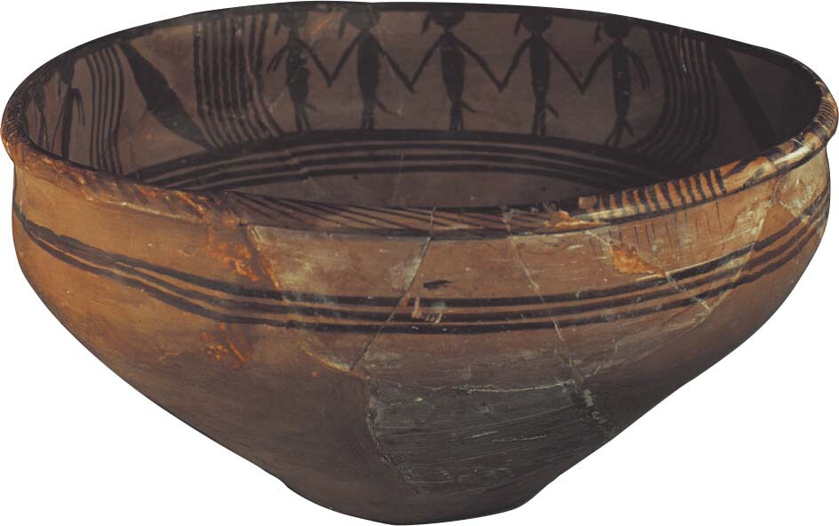
The major divide in China was between the northern Yellow and more centrally located Yangzi river basins. Not only did inhabitants of these two regions rely on different crops—millet in the north and rice in the south—but they built their houses differently, buried their dead in different ways, and produced distinctive pottery styles. The best known of the early cultures developed along the Yellow River and in the Central Plains area and is known as the Yangshao culture.

More information
A Yangshao bowl with dancing people painted on the inside rim. There are three closely grouped together stripes encircling the outside of the bowl and four closely grouped together stripes encircling the inside of the bowl below the dancing figures.
Yangshao villages typically covered 10 to 14 acres and were composed of houses erected around a central square. Villagers had to move frequently because they practiced slash-and-burn agriculture. Once residents had exhausted the soil, they picked up their belongings, moved to new lands, and constructed new villages. Their lives were hard. Excavated cemeteries reveal that nearly 20 percent of the burials were of children fifteen years and younger; only a little more than half of those buried lived past the age of forty.
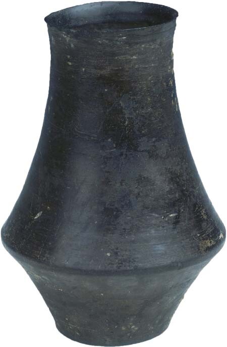
Around 3000 BCE, the Yangshao culture gave way to the Longshan culture, which had an even larger geographical scope and would provide some of the cultural foundations for the first strong states that emerged in the Central Plains. Longshan flourished from 3000 BCE to 2000 BCE and had its center in Shandong Province. Although the Longshan way of life first took form in coastal and southern China, outside the Central Plains, it moved quickly into this hub of economic and political activity. Proof of its widespread cultural influence can be seen from the appearance of a unique style of black pottery, stretching all the way from Manchuria in the north through the Central Plains to the coast and beyond to the island of Taiwan.
The Longshan people likely migrated in waves from the peripheries of East Asia to the eastern China seashore. Their achievements, compared to those of the Yangshao, suggest marked development between 5000 and 2000 BCE. Several independent regional cultures in northern and southern China began to produce similar pottery and tools and to plant the same crops, probably reflecting contact. They did not yet produce city-states, but agriculture and small settlements flourished in the increasingly populated Yellow River valley.
Some of the hallmarks of early urban life are evident in the archaeological remains. Longshan communities built defensive walls for protection and dug wells to supply water. They buried their dead in cemeteries outside their villages. Of several thousand graves uncovered in southern Shanxi Province, the largest ones contain ritual pottery vessels, wooden musical instruments, copper bells, and painted murals. Shamans performed rituals using jade axes. Jade quarrying, in particular, indicated technical sophistication, as skilled craftworkers incised jade tablets with powerful expressions of ritual and military authority. The threat of organized violence among Longshan villages was real. Discoveries at one Longshan site revealed a household whose members were scalped. At this same site, attackers filled the water wells with five layers of human skeletons, some decapitated. Clearly, the villages’ defensive walls were essential.

More information
A Longshan beaker. It is black in color. It is tall and narrow with the widest point about one quarter of the height up from the bottom. It then tapers towards the top and flares outward slightly at the opening. The walls of the beaker are smooth with no decorations.
As communities became more centralized, contact between regions increased. Links between northern and southern China arose when Longshan peoples began to migrate along the East Asian coast to Taiwan and the Pearl River delta in the far south. Similarities in artifacts found along the coast and at Longshan sites in northern China, such as the form and decoration of pottery and jade items, also point to a shared sphere of culture and trade.
Archaeologists also have found evidence of short-lived political organizations. Although they were nothing like the dynastic systems in Egypt, Mesopotamia, and the Indus Valley, they were wealthy—if localized—polities. They constituted what scholars call the era of Ten Thousand States. One of them, the Liangzhu, has drawn particular interest for its remarkable jade objects and its sophisticated farming techniques. The Liangzhu grew rice and fruits and domesticated water buffalo, pigs, dogs, and sheep. Archaeologists have discovered the remains of net sinkers, wooden floats, and wooden paddles, which demonstrate a familiarity with watercraft and fishing. Artisans produced a black pottery from soft paste thrown on a wheel, and like the Longshan, they created ritual objects from several varieties of jade. Animal masks and bird designs adorned many pieces, revealing a shared cosmology that informed the rituals of the Liangzhu elite.
In the late third millennium BCE, a long drought hit China (as it did Egypt, Mesopotamia, and India). Although climate change limited progress and forced migrations to more dependable habitats, the Chinese recovered early in the second millennium BCE. Now they created elaborate agrarian systems along the Yellow and Yangzi Rivers that were similar to earlier irrigation systems along the Euphrates, Indus, and Nile. Extensive trading networks and a stratified social hierarchy emerged; like the other river-basin complexes of Asia and North Africa, China became a centralized polity. Here, too, a powerful monarchy eventually united the independent communities. But what developed in China was a social and political system that emphasized an idealized past and a tradition represented by sage-kings, which later ages emulated. In this and other ways, China diverged from the rest of Afro-Eurasia.