Where? Survey and Excavation of Sites and Features
A major characteristic of archaeology is that it commonly draws evidence from fieldwork, that is, from survey and excavation. Traditionally, fieldwork was seen almost exclusively in terms of the discovery and uncovering of sites. Today, archaeologists are more aware of the high cost and destructiveness of excavation, and so while sites and their excavation remain of paramount importance, site surface survey and subsurface detection using non-destructive remote sensing devices are now widely used. Indeed, some archaeological projects may not include excavation at all, and instead focus on various forms of survey. The use of non-invasive survey not only leaves the archaeology undisturbed but also helps to answer new questions. For example, the study of entire landscapes by regional survey is now a major part of archaeological fieldwork.
In archaeological fieldwork, we may distinguish between the methods used in the discovery of archaeological sites and non-site features or artifact scatters, and those employed once those sites and features have been discovered, which include detailed survey and selective excavation at individual sites. It is important to note that new evidence can often come from new work at sites already the subject of fieldwork, such as Ian Hodder’s renewal and reappraisal of the excavations of the Turkish tell site of Çatalhöyük (see box, pp. 44–45). Much potentially rich and rewarding material also lies locked away in museum and institution vaults, waiting to be analyzed by innovative modern techniques. Yet it remains true that the great majority of archaeological research is still dependent on the collection of new material by fresh fieldwork.
Discovering Archaeological Sites and Features
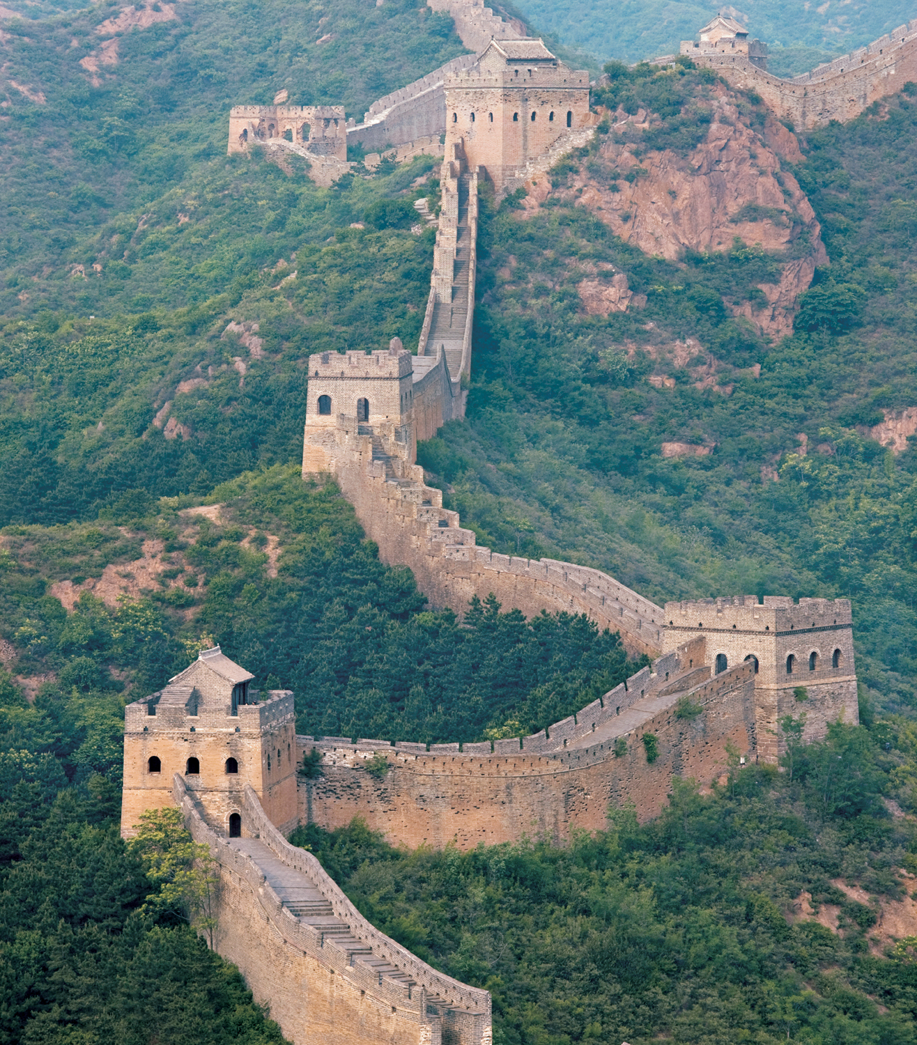
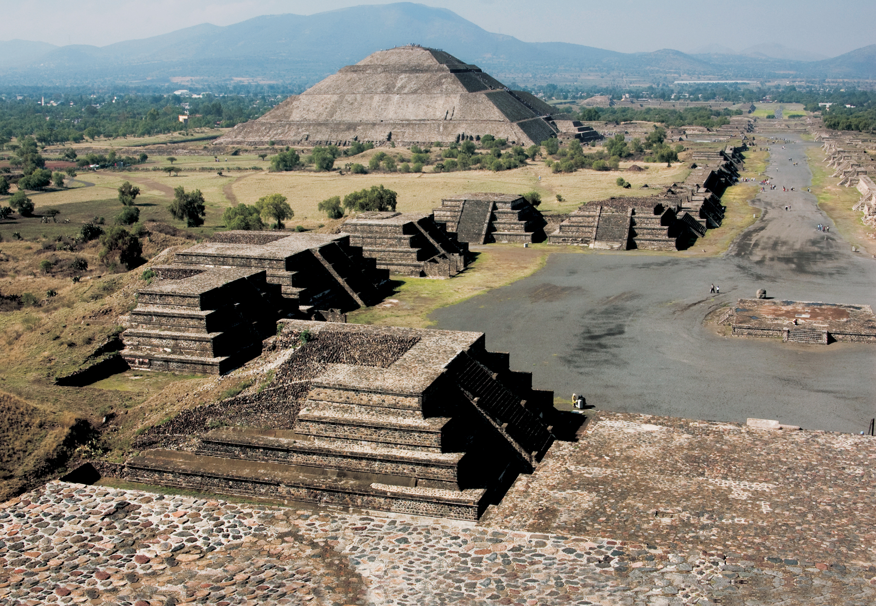
One major task of the archaeologist is to find and record the location of sites and features. In this section we will be reviewing some of the principal techniques used in site discovery. But we should not forget that many monuments have never been lost to posterity: the massive pyramids of Egypt, or those of Teotihuacán near modern Mexico City, have always been known to succeeding generations, as has the Great Wall of China or many of the buildings in the Forum in Rome. Their exact function or purpose may indeed have aroused controversy down the centuries, but their presence, the fact of their existence, was never in doubt.
Nor can one credit archaeologists with the discovery of all those sites that were once lost. A significant number of sites known today were found by accident: the amazing terracotta army of China’s first emperor was unearthed in 1974 by farmers digging for a well; in France, the decorated caves of Lascaux were stumbled upon in 1940 by teenagers, and the underwater entrance to those of Cosquer was discovered by a deep-sea diver in 1985. Countless underwater wrecks have been spotted first by fishermen, sponge-gatherers, and sport-divers. Construction workers building new roads, subways, dams, and office blocks have made their fair share of discoveries too—for example, the Templo Mayor (Great Temple) of the Aztecs in Mexico City (see box, pp. 570–71).
Nevertheless, it is archaeologists who have systematically attempted to record these sites, and it is archaeologists who seek out the full range of sites and features, large or small, that make up the great diversity of past landscapes. How do they achieve this?
A practical distinction can be drawn between site discovery conducted at ground level (ground reconnaissance) and discovery from the air or from space (aerial survey), although any one field project will usually employ both types of reconnaissance.
Ground Reconnaissance
Methods for identifying individual sites include consultation of documentary sources and place-name evidence, but primarily comprises actual fieldwork, whether the monitoring of building developers’ progress in applied or compliance archaeology (often known in the UK as salvage or rescue archaeology), or survey in circumstances where the archaeologist is more of a free agent.
Documentary Sources.
We saw how Schliemann’s firm belief in the historical accuracy of the writings of Homer led directly to the discovery of ancient Troy in
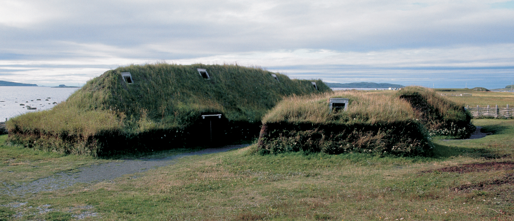
Chapter 1. In the 1960s, the location and excavation by Helge and Anne Stine Ingstad of the Viking settlement of L’Anse aux Meadows in Newfoundland was similarly due in large part to clues contained in medieval Viking sagas. Much of modern biblical archaeology concerns itself with the search in the Near East for evidence of the places, people, and events described in the Old and New Testaments. Treated objectively as a possible source of information about Near Eastern sites, the Bible can indeed be a rich source of documentary material, but there is certainly the danger that belief in the absolute religious truth of the texts can cloud an impartial assessment of their archaeological validity.
Much research in biblical archaeology involves attempting to link named biblical sites with archaeologically known ones. Place-name evidence, however, can also lead to actual discoveries of new archaeological sites. In southwest Europe, for example, many prehistoric stone tombs have been found thanks to old names printed on maps that incorporate local words for “stone” or “tomb.”
Early maps and old street names are even more important in helping archaeologists work out the former plans of historic towns. In England, it is possible in the better-documented medieval towns to map many of the streets, houses, churches, and castles back to the twelfth century CE, or even earlier, using this kind of evidence. Such maps then form a reliable basis on which to decide where it would be most profitable to carry out survey work and excavation.
Cultural Resource Management and Applied or Compliance Archaeology.
In this specialized work (discussed in Chapter 15), the role of the archaeologist is to locate and record sites before they are destroyed by new roads, buildings, or dams, or by peatcutting and drainage in wetlands. In the USA a large number of sites are located and recorded in inventories every year under cultural resource management (CRM) laws, which were considerably broadened and strengthened in the 1970s. Proper liaison with the developer should allow archaeological survey to take place in advance along the projected line of road or in the path of development. Important sites thus discovered may require excavation, and in some cases can even cause construction plans to be altered. Certain archaeological remains unearthed during the digging of subways in Rome and Mexico City were incorporated into station architecture.
3.1 Partially buried but never lost: buildings in the Forum of ancient Rome, as depicted in an early nineteenth-century painting by the Italian artist Ippolito Caffi.3.2 The Great Wall of China, more than 2,000 km (1,250 miles) long, was begun in the third century BCE. Similarly to the Forum, it has never been lost to posterity.3.3 The low mounds at L’Anse aux Meadows turned out to be the remains of huts with walls and roofs of turf supported by a wood frame—those seen here have been reconstructed for visitors. Lack of evidence for rebuilding indicates this was a short-lived settlement.
In Britain, as in the USA, most excavations and surveys are undertaken in the context of cultural resource management—the influence of the British “National Planning Policy Framework” has meant that expenditure on archaeology by developers has grown to more than £10 million ($15.4 million) annually.
Survey.
How does the archaeologist set about locating sites, other than through documentary sources and salvage work? A conventional and still valid method is to look for the most prominent remains in a landscape, particularly surviving remnants of walled buildings, and burial mounds such as those in eastern North America or Wessex in southern England. But many sites are visible on the surface only as a scatter of artifacts and so require more thorough survey—what we may call a “reconnaissance survey”—to be detected.
In recent years, as archaeologists have become more interested in reconstructing the full human use of the landscape, they have begun to realize that there are very faint scatters of artifacts that might not qualify as sites, but which nevertheless represent significant human activity. Some scholars have suggested that these “off-site” or “non-site” areas (that is, areas with a low density of artifacts) should be located and recorded, which can only be done by systematic survey work involving careful sampling procedures (see below). This approach is particularly useful in areas where people leading a mobile way of life have left only a sparse archaeological record, as in much of Africa (see further discussion in Chapter 5).
Survey has become important for another major reason: the growth of regional studies. Thanks to the pioneering researches of scholars such as Gordon Willey in the Virú Valley, Peru, and William T. Sanders (1926–2008) in the Valley of Mexico, archaeologists increasingly seek to study settlement patterns—the distribution of sites across the landscape within a given region. The significance of this work for the understanding of past societies is discussed further in Chapter 5. Here we may note its impact on archaeological fieldwork: it is rarely enough now merely to locate an individual site and then to survey it and/or excavate it in isolation from other sites. Whole regions need to be explored, involving a program of survey.
In the last few decades, reconnaissance survey has developed from being simply a preliminary stage in fieldwork (looking for appropriate sites to excavate) to a more or less independent kind of inquiry, an area of research in its own right which can produce information quite different from that achieved by digging. In some cases, excavation may not take place at all, perhaps because permission to dig was not forthcoming, or because of a lack of time or funds—modern excavation is slow and costly, whereas survey is cheap, quick, relatively non-destructive, and requires only GPS, maps, compasses, and tapes. Usually, however, archaeologists deliberately choose a surface approach as a source of regional data in order to investigate specific questions that interest them and that excavation could not answer.
Survey encompasses a broad range of techniques: no longer just the identification of sites and the recording or collection of surface artifacts, but sometimes also the sampling of natural and mineral resources such as stone and clay. Much survey today is aimed at studying the spatial distribution of human activities, variations between regions, changes in population through time, and relationships between people, land, and resources.
Survey in Practice.
For questions formulated in regional terms, it is necessary to collect data on a corresponding scale in a way that provides the most information for the least cost and effort. The region to be surveyed needs to be defined: its boundaries may be natural (such as a valley), cultural (the extent of an artifact style), or purely arbitrary, though natural boundaries are the easiest to establish.
The area’s history of development needs to be examined, not only to familiarize oneself with previous archaeological work and with the local materials but also to assess the extent to which surface material may have been covered or removed by natural processes. There is little point, for example, in searching for prehistoric material in sediments only recently laid down by river action. Other factors may have affected surface evidence as well. In much of Africa, for example, great animal herds or burrowing animals will often have disturbed surface material, so that the archaeologist may be able to examine only very broad distribution patterns. Geologists and environmental specialists can generally provide useful advice.
This background information will help determine the intensity of surface coverage of the survey. Other factors to take into consideration are the time and resources available, and how easy it is actually to reach and record an area. Arid and semi-arid environments with little vegetation are among the best for this type of work; in equatorial rainforest, survey may be limited to soil exposures along river banks, unless time and labor permit the cutting of trails to form a survey grid. Many regions, of course, contain a variety of landscapes, and a single survey strategy is often inadequate to cover them. Flexibility of approach is required, with the area “stratified” into zones of differing visibility, and an appropriate technique devised for each. Moreover, it must be remembered that some archaeological phases (with diagnostic artifacts) are more “visible” than others, and that mobile hunter-gatherer or pastoral communities leave a very different—and generally sparser—imprint on the landscape than do agricultural or urban communities (see Chapter 5). All these factors must be taken into account when planning search patterns and recovery techniques.
Another point to consider is whether material should be collected or merely examined for its associations and context (where context is disturbed, as in parts of Africa, mentioned above, collection is often the most sensible option). And should collection be total or partial? Usually, a sampling method is employed (see box, p. 80).
There are two basic kinds of surface survey: the unsystematic and the systematic. The former is the simpler, involving walking across each part of the area, scanning a strip of ground, collecting or examining artifacts on the surface, and recording their location together with that of any surface features. It is generally felt, however, that the results may be biased and misleading. Walkers have an inherent desire to find material, and will therefore tend to concentrate on those areas that seem richer, rather than obtaining a sample representative of the whole area that would enable the archaeologist to assess the varying distribution of material of different periods or types. On the other hand, the method is flexible, enabling the team to focus greater efforts on the areas that have proved most likely to contain finds.
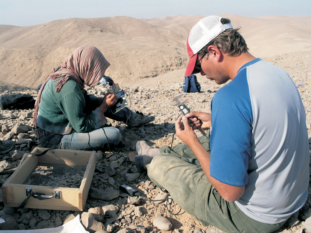
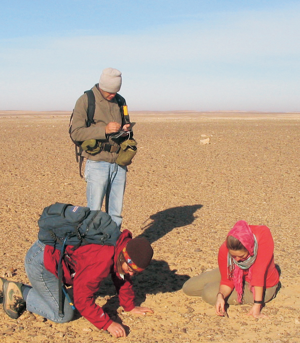
3.4–5 Systematic surface survey in the Egyptian desert: using GPS, archaeologists sample small areas spaced 100 m (328 ft.) apart, looking for Middle Paleolithic stone tools. Finds are then processed in the field using electronic calipers and handheld computers.
Most modern survey is done systematically, employing either a grid system or a series of equally spaced traverses or transects (straight paths) across the area. The area to be searched is divided into sectors, and these (or a sample of them) are walked. In this way, no part of the area is either under- or overrepresented in the survey. This method also makes it easier to plot the location of finds since one’s exact position is always known. Even greater accuracy can be attained by subdividing the traverses into units of fixed length, some of which can then be more carefully examined.
The Sydney Cyprus Survey Project
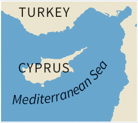
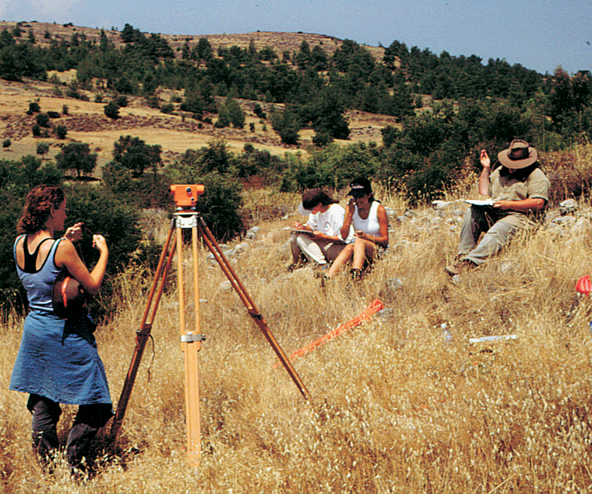
From 1992 to 1998 the Sydney Cyprus Survey Project (SCSP), led by Bernard Knapp and Michael Given of the University of Glasgow, undertook an intensive archaeological survey in a 75-sq. km (29-sq. mile) area in the northern Troodos Mountains of Cyprus. This is an area famed for its copper sulfide ore deposits, exploited as early as the Bronze Age.
The project examined the human transformation of the landscape over 5,000 years and placed it in its regional context. An interdisciplinary approach integrated such diverse fields as archaeology, archaeometallurgy, ethnohistory, geomorphology, ecology, GIS (geographic information systems, see p. 93), and satellite imagery, without overlooking the human experience of place.
Project Aims and Design
Primary goals of the project were to use archaeological landscape data to analyze the relationship between the production and distribution of agricultural and metallurgical resources through time, and to chart the changing configurations of a complex society and the individuals within it.
A multi-stage research design was adopted, and the notion of the “site” was called into question. A first requirement for the systematic intensive survey strategy was good maps. Enlarged aerial photographs were used to create a base map of the entire survey region. Using the GIS program MapInfo, the photographs were scanned and registered to the UTM (Universal Transverse Mercator) grid with grid lines of 100-m (328-ft.) spacing superimposed on the base map. The Cypriot Lands and Survey Department assisted by giving GPS (global positioning system) readings for survey points in the study area.
The landscape was divided into single units. In some cases, features in the landscape, such as agricultural plots, defined these units. Otherwise the main survey approach was to follow a straight line, or transect survey, with the following strategies:
to walk 50-m (165-ft.) wide transects north–south (with fieldwalkers 5 m (16 ft.) apart) across the survey area at 500-m (1650-ft.) intervals, in order to obtain a broad systematic sample of the survey area;
to use spatial information entered daily into the GIS to determine which topographic, geological, and land-use factors may have conditioned the occurrence of exposed cultural materials;
to conduct block survey of “special interest areas” with extensive evidence of early industrial, agricultural, or settlement activities;
to investigate, as “places of special interest,” locales designated by obtrusive remains or high densities of artifacts.
In each unit, a representative sample of cultural material was collected: pottery, chipped stone, ground stone, metals, slag, ores and fluxes, glass, and tiles. Other, mainly non-diagnostic, material was simply counted and left in the unit.
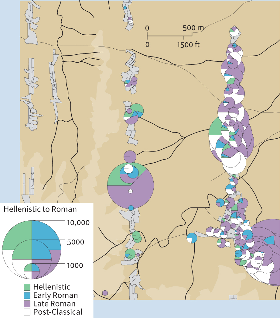
A major component of the SCSP consisted of using GIS-derived thematic maps to illustrate the results of the field counting, collecting, and recording strategy. Pottery was the key analytical aspect in assessing the meaning and significance of the survey units, and pottery data (density and distribution) were incorporated into GIS maps. A Pottery Index (PI), adjusted for ground visibility and other factors, was used to indicate the importance of a specific time period within a unit. A PI of 500–1,000 was taken to indicate a light scatter of pottery derived from agricultural practices such as manuring; a PI of 5,000 might suggest a low-density habitation, such as a farmstead; whereas a PI of 10,000 suggested the very high densities found on major settlements.
Results
In all, 1,550 survey units were surveyed, covering 6.5 sq. km (2.5 sq. miles), or 9.9 percent of the survey area. The survey identified eleven “special interest areas” and 142 “places of special interest”. The count in the field totaled 87,600 sherds of pottery, 8,111 tile fragments, and 3,092 lithics. About one-third of these were collected and analyzed and entered into the project’s database.
The project could conclude that the “chronotype” cataloguing and information system was integrated with pottery analyses and GIS mapping to present a new perspective on the exploitation of a regional landscape. The Pottery Index sought to bring new rigor to the mapping of regional pottery data. The GIS analytical maps portrayed in a vivid and dynamic way the level and types of materials encountered.
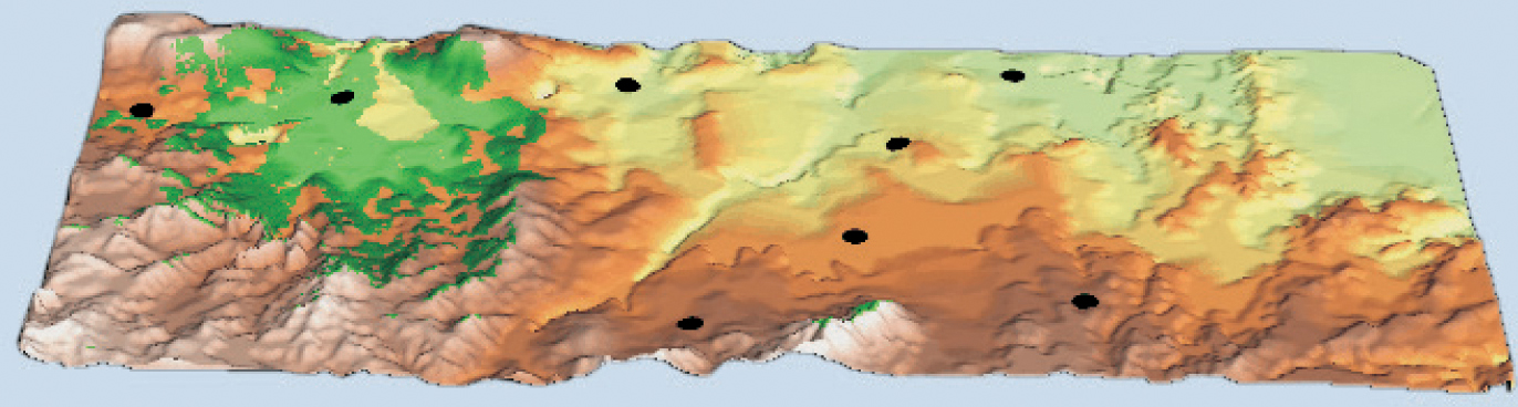
3.6 Mapping Mitsero Mavrouvounos.3.7 Viewshed analysis (see p. 185) of the survey area: black dots are medieval to modern settlements and the tinted area shows what is visible from Mitsero.
The general conclusion that it took around six years to undertake an intensive survey of roughly 10 percent of an area of only 75 sq. km (29 sq. miles) is of note. Moreover the “chronotype” cataloguing system was dependent upon reasonably abundant pottery finds that could be classified chronologically according to an already well-established typological system. The availability of a chronologically sensitive indicator of this kind is of crucial relevance for any survey analyzing change over time. However, the system also intentionally included a very large range of wares that previously had not been datable by any field project on Cyprus.
3.8 A distribution diagram of pottery (the Pottery Index) in the northeast part of the survey area, showing low-density “carpets” probably derived from manuring, the edge of the city of Tamssos at bottom right, and several density spikes from estates or small settlements.
Results tend to be more reliable from long-term projects that cover the region repeatedly, since the visibility of sites and artifacts can vary widely from year to year or even with the seasons, thanks to vegetation and changing land use. In addition, members of field crews inevitably differ in the accuracy of their observations, and in their ability to recognize and describe sites (the more carefully one looks, and the more experience one has, the more one sees); this factor can never be totally eliminated, but repeated coverage can help to counter its effects. The use of standardized recording forms makes it easy to put the data into a computer at a later stage, or handheld computers can be used in the field.
It is important to stress that material found on the surface quite often represents sites beneath, the upper levels of which have been, or are being, removed by plowing, erosion, or later development. Conversely, surface material may also fail to indicate what lies below—for example if pottery was deposited by manuring, or if cultures are aceramic and hence underrepresented in the survey. This is why it may be necessary or desirable to carry out small excavations to supplement or check the surface data (particularly for questions of chronology, contemporaneity, or site function), or to test hypotheses that have arisen from the survey. The two types of investigation are complementary, not mutually exclusive. Their major difference can be summarized as follows: excavation tells us a lot about a little of a site, and can only be done once, whereas survey tells us a little about a lot of sites, and can be repeated.
Extensive and Intensive Survey.
Surveys can be made more extensive by combining results from a series of individual projects in neighboring regions to produce very large-scale views of change in landscape, land use, and settlement through time—though, as with individual members of a field crew, the accuracy and quality of different survey projects may vary widely. Outstanding syntheses of regional survey have been produced in parts of Mesoamerica (see Chapter 13) and Mesopotamia, areas which already have a long tradition of this type of work.
In Mesopotamia, for example, the pioneering work by Robert Adams (1926–2018) and others, combining surface and aerial survey, has produced a picture of changing settlement size and spacing through time leading to the first cities: scattered agricultural villages became more clustered as population increased; eventually, by the Early Dynastic period (third millennium BCE), major centers of distribution had arisen, interconnected by routes of communication. The work has also revealed former watercourses and canals, and even probable zones of cultivation.
Sampling Strategies
Archaeologists cannot usually afford the time and money necessary to investigate the whole of a large site or all sites in a given region, so they need to sample the area being researched. In a ground reconnaissance survey, this will involve using one of the methods described below to choose a number of smaller areas to be searched, with the objective being to draw reliable conclusions about the whole area.
The way archaeologists use sampling is similar to the way it is employed in public-opinion polls, which make generalizations about the opinions of millions of people using samples of just a few thousand. Surprisingly often, the polls are more or less right. This is because the structure of sampled populations is well known—for example, we know their ages and occupations. We have much less background information to work with in archaeology, so must be more careful when we extrapolate generalizations from a sample. But as with opinion polls, in archaeological work the larger and better designed the sample, the more probable the results are to be valid.
Some sites in a given region, however, may be more accessible than others, or more prominent in the landscape, which may prompt a more informal sampling strategy. Long years of experience in the field will also give some archaeologists an intuitive “feel” for the right places to undertake work.
Types of Sampling
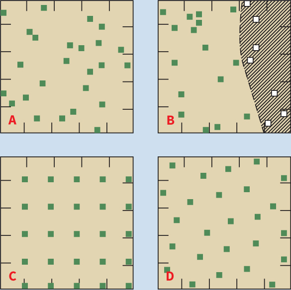
The simplest form is a simple random sample, where the areas to be sampled are chosen using a table of random numbers. However, the nature of random numbers results in some areas being allotted clusters of squares, while others remain untouched—the sample is, therefore, inherently biased.
One answer is the stratified random sample, where the region or site is divided into its natural zones (or strata, hence the technique’s name), such as cultivated land and forest, and squares are then chosen by the random-number procedure, except that each zone has the number of squares proportional to its area. Therefore, if forest comprises 85 percent of the area, it must be allotted 85 percent of the squares.
Another solution, systematic sampling, entails the selection of a grid of equally spaced locations—e.g. choosing every other square. By adopting such a regular spacing one runs the risk of missing (or hitting) every single example in an equally regular pattern of distribution—this is another source of potential bias.
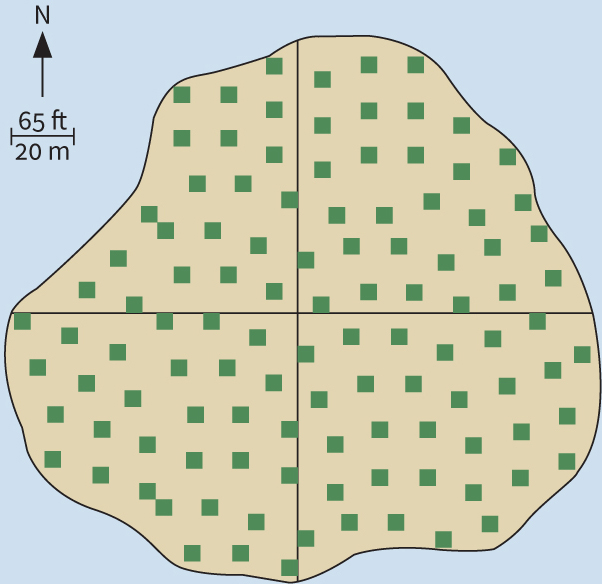
A more satisfactory method is to use a stratified unaligned systematic sample, which combines the main elements from all three techniques just described. In collecting artifacts from the surface of a large tell or mound site at Girik-i-Haciyan in Turkey, Charles Redman and Patty Jo Watson used a grid of 5-m (16-ft.) squares, but oriented it along the site’s main north–south and east–west axes, and the samples were selected with reference to these axes. The strata chosen were blocks of nine squares (three by three), and one square in each block was picked for excavation by selecting its north–south/east–west coordinates from a table of random numbers. This method ensures an unbiased set of samples, more evenly distributed over the whole site.
3.10 Stratified systematic sample of squares, 5 m (16 ft.) on a side, chosen for investigation at Girik-i-Haciyan, Turkey.
Transects vs. Squares
In large-scale surveys, transects (straight paths) are sometimes preferable to squares. This is particularly true in areas of dense vegetation such as tropical rainforest. It is far easier to walk along a series of paths than to locate accurately and investigate a large number of randomly distributed squares. In addition, transects can easily be segmented into units, whereas it may be difficult to locate or describe a specific part of a square; and transects are useful not merely for finding sites but also for recording artifact densities across the landscape. On the other hand, squares have the advantage of exposing more area to the survey, therefore increasing the probability of intersecting sites. A combination of the two methods is often best: using transects to cover long distances, but squares when larger concentrations of material are encountered.
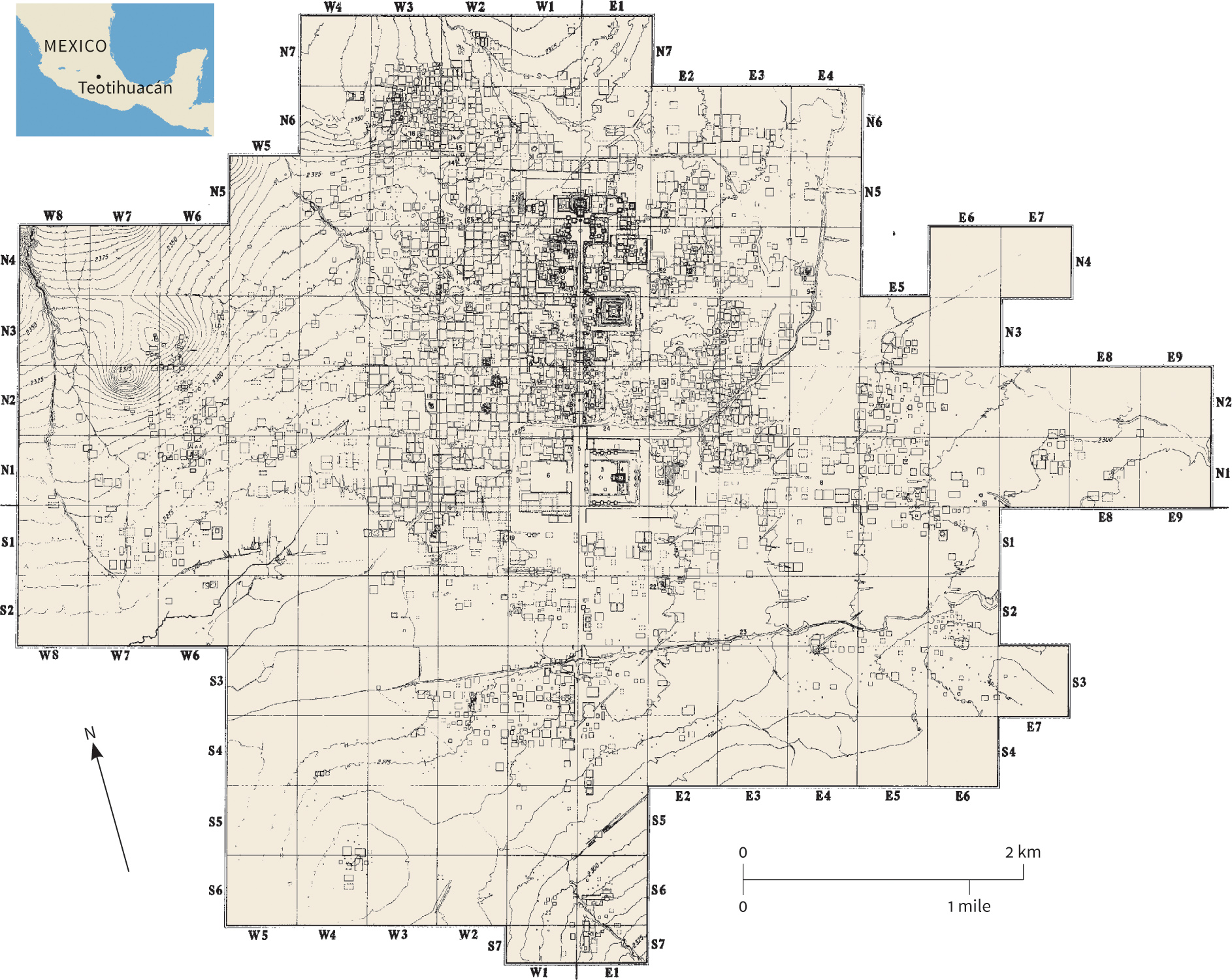
Alternatively, survey can be made more intensive by aiming at total coverage of a single large site or site-cluster—what one might call “micro-regional” survey. It is a paradox that some of the world’s greatest and most famous archaeological sites have never, or only recently, been studied in this way, since attention has traditionally focused on the grandiose monuments themselves rather than on any attempt to place them within even a local context. At Teotihuacán, near Mexico City, a major mapping project initiated in the 1960s has added hugely to our knowledge of the area around the great pyramid-temples (see pp. 97 and 100).
Surface survey has a vital place in archaeological work, and one that continues to grow in importance. In modern projects, however, it is usually supplemented (and often preceded) by reconnaissance from above—either from the air or from space. In fact, the availability of aerial images can be an important factor in selecting and delineating an area for surface survey.
Aerial and Satellite Survey
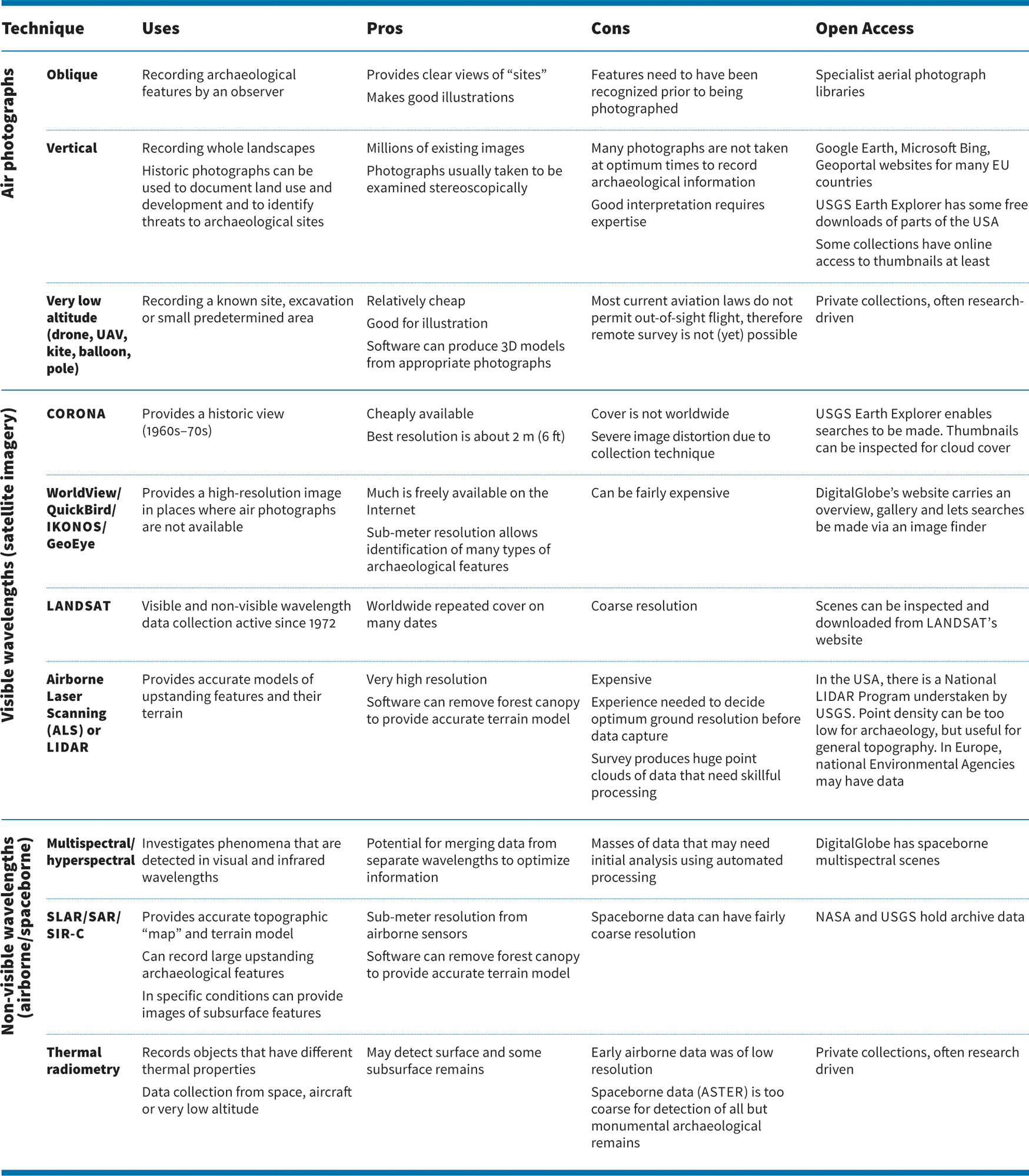
Archaeological survey using airborne or spaceborne remote sensing can be divided into two component parts: data collecting, which comprises acquiring photographs or images from aircraft, satellites, or UAVs (drones); and data analysis, in which these images are analyzed, interpreted, and (often) integrated with other evidence, such as may be collected by field survey, ground-based remote sensing, or from documents. From the viewpoint of the photo interpreter or image analyst, satellite images, multispectral/hyperspectral data, and traditional aerial photographs are all potentially useful sources, though they differ in scale and resolution and carry different issues of interpretation. These data will collectively be referred to as “aerial images.”
Millions of aerial images have already been taken Many are available for consultation in specialist libraries; a lesser quantity is freely available online. Most result from “area survey,” in which aerial images are taken in overlapping series to cover predefined areas. A small number are taken each year by archaeologists conducting prospective surveys in light aircraft. It must be stressed that aerial images, even those from prospective survey, are used for a wide range of archaeological purposes, such as the discovery and recording of sites, and the monitoring of changes in them through time, or the photographing of buildings and urban (and other) development—in fact, recording almost anything that “may not be there tomorrow.” Nevertheless, the taking and analysis of aerial images from aircraft or satellite has led to a large number of archaeological discoveries, and the tally grows every year.
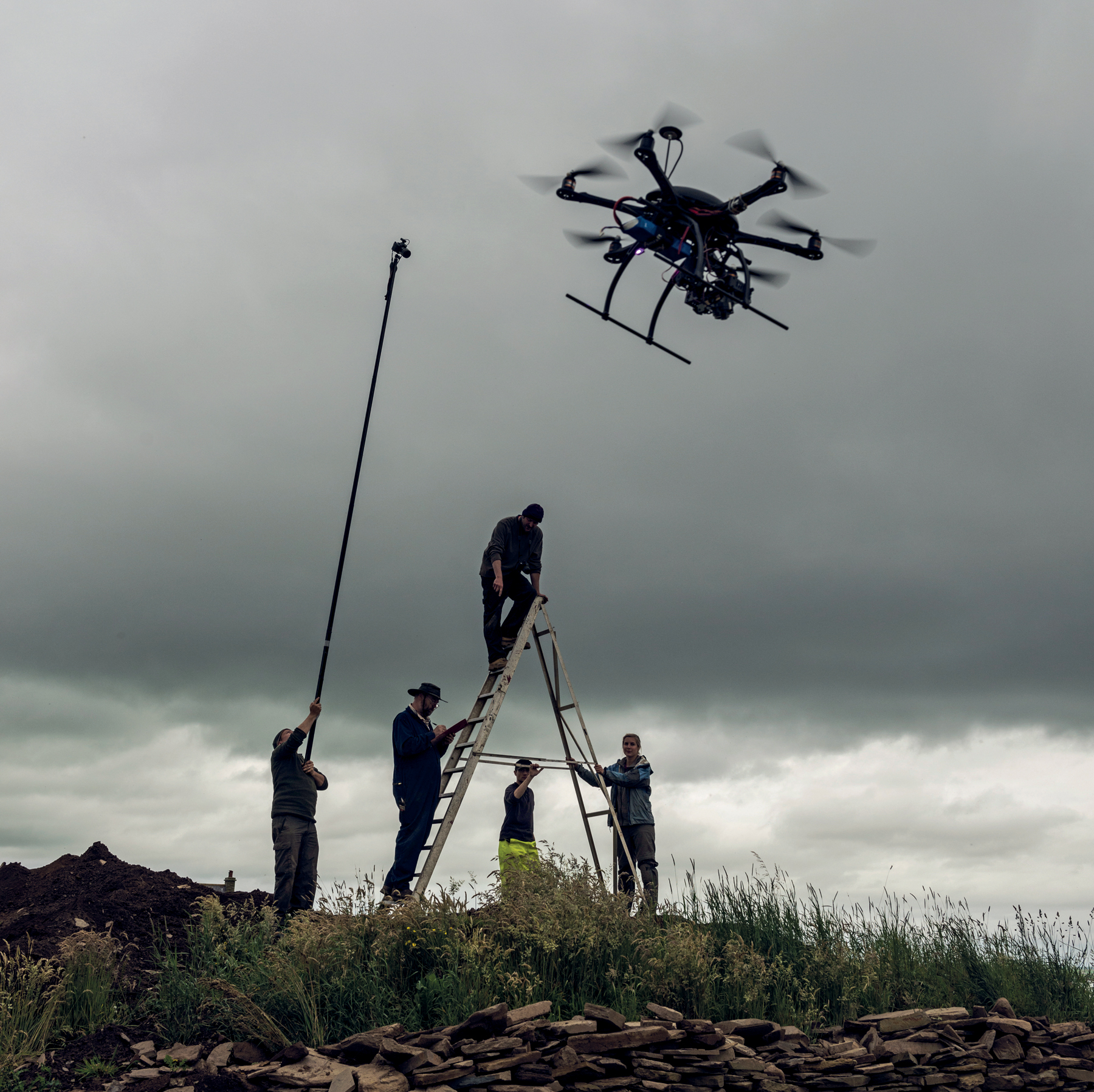
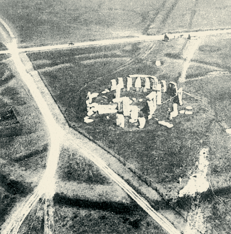
3.11 Aerial photography, from the earliest to most recent. The use of a drone in the survey of the Ness of Brodgar, a Neolithic sacred site in the Orkney Islands, Scotland.3.12 Aerial photography, from the earliest to most recent. The first air photograph of Stonehenge (or of any archaeological site) taken from a balloon in 1906.
How Are Aerial Images Used?
Images taken from the air are merely tools; they are a means to an end. Images do not themselves reveal sites—it is the image taker and the interpreter who do so, by examination of the terrain and the pictures. These are specialized skills. Experience and a keen eye are needed to differentiate archaeological traces from other features—such as vehicle tracks, old riverbeds, and patterns produced by modern cultivation—a process that benefits from a broad understanding of landscape history, including an awareness of contemporary processes.
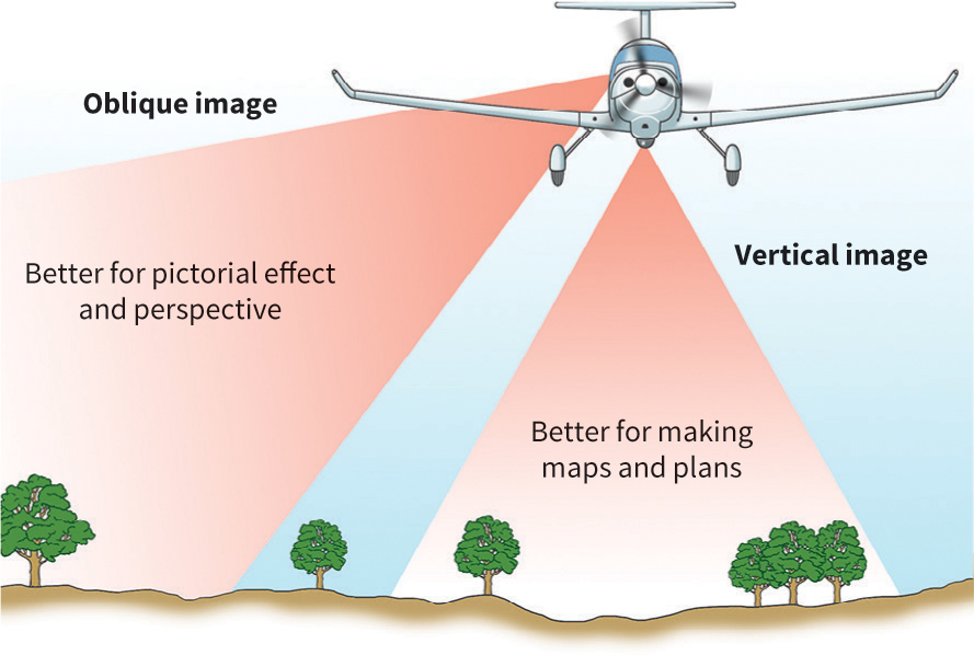
Aerial images are of two types: oblique and vertical. Each has its advantages and drawbacks, but oblique images have usually been taken of sites observed from the air by an archaeologist and thought to be of archaeological significance, whereas most vertical images result from non-archaeological surveys (for instance, cartographic surveys). Both types of image can be used to provide overlapping stereoscopic pairs of prints that enable a scene to be examined in three dimensions and so add confidence to any interpretation. Stereoscopic pictures taken of the ancient city of Mohenjodaro in Pakistan from a tethered balloon, for example, have enabled photogrammetric (accurately contoured) plans to be made of its surviving structures. Similarly, large areas can be surveyed with overlapping images, which are then processed into a very accurate photographic base map of all the archaeological evidence visible from the air. Such images are a useful tool to inform analytical ground survey.
The ways in which sites show from the air and how they are interpreted are discussed in the box overleaf. Oblique images are often targeted on archaeological features that may show clearly, while vertical images may need to be more thoroughly examined by an interpreter seeking such information. Both types of image can be rectified and georeferenced using computer programs. This removes the scale and perspective distortions of oblique images and can correct for tilt and off-nadir distortion in vertical views. Use of a digital terrain model (making a 3D model of the ground based on contours or via LIDAR or ALS data—see below) in the rectification process produces greater accuracy where the ground is undulating or has high relief. After computer transformation, the resulting image may be layered in graphics software or a GIS (see pp. 94–97) and interpreted by overdrawing the archaeological features that have been identified. Site-specific mapping at scales of 1:2,500 can show considerable detail within a site and can be accurate to less than ± 1 m (± 3 ft.). This allows features to be measured and compared and is essential in providing precise locations so that excavation trenches can be positioned accurately and cost-effectively (see box, p. 88–89). This is the usual method for interpreting and mapping archaeological features from aerial images in Britain and Europe and could be a useful tool elsewhere.
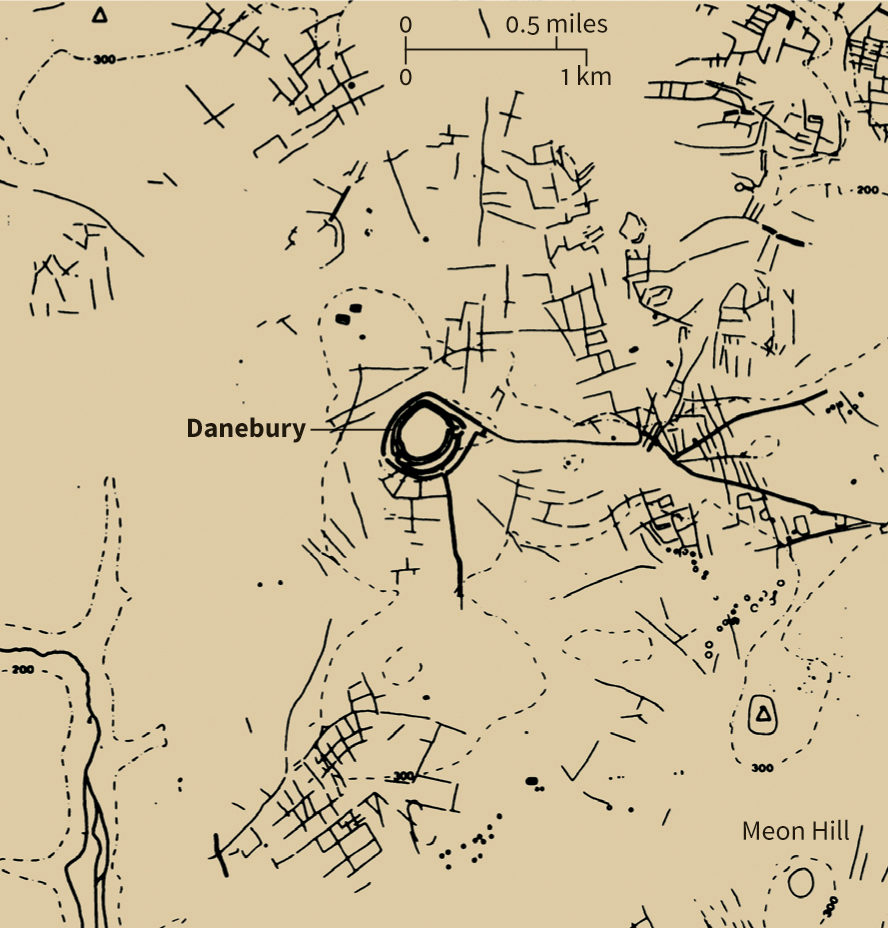
Mapping of individual sites from aerial photographs is often necessary in research or salvage (rescue) archaeology and also forms the foundations of landscape mapping and understanding. The ability to study large areas is often only possible using aerial resources. In Britain, Rog Palmer used thousands of individual photographs of a 450-sq. km (175-sq. mile) territory around the Iron Age hillfort of Danebury in Hampshire to produce accurate maps. These show that the site lay within very complex agricultural landscapes, with at least eight other hillforts in the area. Crop-marks (explained in the box, pp. 84–85) revealed the presence of 120 ditched settlement enclosures, hundreds of acres of small fields, regularly arranged, and 240 km (150 miles) of linear ditches and boundary works, many of which were roughly contemporaneous with Danebury, to judge from their forms and selective excavation by the Danebury Environs Programme.
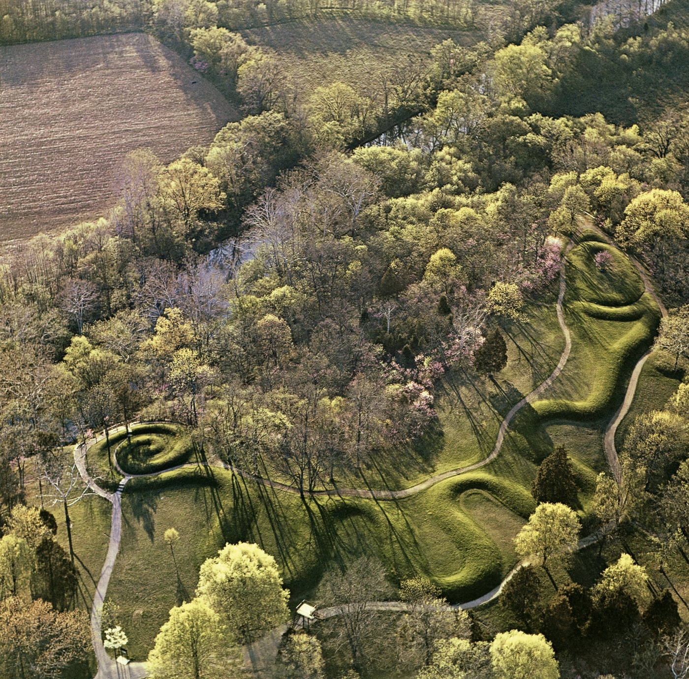
3.13 Aerial images are of two types: oblique and vertical. Obliques are easier to view and understand than verticals, but may present more difficulty to the interpreter who must transform the information to obtain plan views.3.14 An oblique aerial image of the earthwork at Great Serpent Mound, near Peebles, Ohio, the largest serpent effigy in the world, built c. 1070 CE.3.15 Map of the area around Danebury, an Iron Age hillfort in southern Britain (sixth–second centuries BCE), created from aerial survey, with details of ancient fields, tracks, and enclosures.
Although it was known that prehistoric roadways existed within Chaco Canyon in the American Southwest, it was only when a major aerial reconnaissance project was undertaken by the National Park Service in the 1970s that the full extent of the system of roads was appreciated. Using the extensive coverage provided by the aerial images, a whole network of prehistoric roadways was identified and mapped (see p. 401). This was followed by selective ground surveys and some archaeological excavation. From the aerial coverage, it has been estimated that the network, thought to date to the eleventh and twelfth centuries CE, extends some 2,400 km (1,500 miles), though of this only 208 km (130 miles) have been examined at ground level.
Global Positioning Systems.
Aerial survey often takes advantage of GPS navigation and flight-path recording by using the digital sensors in precision vertical cameras or in the handheld cameras of airborne archaeologists. The track of a vertical-survey flight is recorded at preset intervals to provide a continuous record that shows the ground that has been overflown and searched. Many handheld cameras can be linked to GPS so that coordinates are recorded as each photograph is taken. This eases the occasional problem of locating shots when the archaeologist is back on the ground. It is also wise to devise a storage system that allows rapid retrieval of images, is adequately backed up, and takes account of the possible short-term life of digital formats, so as to provide good archival storage of what may be unique data.
Different forms of image, such as vertical photographs and satellite images, are often georeferenced so that they can be layered in a GIS. The application of digital image analysis is now a basic element in the survey archaeologist’s toolkit. Just as in excavation and aerial survey, this form of remote sensing research must be well planned and well executed, using a comprehensive methodology.
Recent Developments.
New methods and technologies are being developed constantly, and archaeologists are often keen to adopt any technique that promises a new perspective or a more straightforward or cost-effective solution. Automated and semi-automated image analysis is commonplace in disciplines such as environmental remote sensing where work is undertaken on extensive datasets. Aspects of these developments have seen some archaeological application, and researchers are investigating ways in which computers might reliably handle large datasets, such as those that will be generated by hyperspectral surveys. Software can be written to extract features with defined characteristics from data (i.e. pits or mounds) and these should form a useful complement to traditional image analysis. Digital data, such as ALS (airborne laser scanning: see below), respond very well to heavily automated workflows, as illustrated by a six-year project which surveyed 35,000 sq. km (21,750 sq. miles) of Baden-Württemberg in Germany using supervised automated classification and identified a possible 600,000 sites. Applications of “deep learning” are at the cutting edge of automated detection, bringing artificial intelligence to bear in the processes of pattern recognition. This demands careful consideration of the ways in which a human observer may work, drawing on experience and knowledge but also constrained by expectation, and of what artificial intelligence is capable of identifying.
Identifying Archaeological Features from Above
Features Visible from Above
Successful identification of archaeological sites on aerial images requires knowledge of the types of feature that we may expect to be visible and of formation processes that may have affected them since their abandonment. In general, for a site to be detected by a remote sensing method it needs to have altered the soil or subsoil. These alterations can vary between holes cut into the ground (such as ditches and pits) and features placed upon it (such as banks, mounds, and walls), either of which may survive in relief or be completely buried under leveled, cultivated land. Previous fieldwork and excavations in the area of interest should identify the range and characters of archaeological features that may be visible from above, although the smallest of these (postholes, for example) may not be seen on any but the clearest and largest-scale images. Such knowledge of the area or region will also help the interpreter to differentiate between archaeological and non-archaeological features.
Upstanding Sites
It is important to remember that similar holes and bumps may have been caused by natural disturbances (such as cracked and pitted ground resulting from periglacial activity—repeated freezing and thawing) or by recent human intervention (leveling field boundaries or digging small quarries, for example). An experienced image analyst should be able to identify these and distinguish them from archaeological features in an area with which they are familiar.
Sections cut through the experimental earthwork on Overton Down in southern England (see p. 53) found that, in an undisturbed chalk landscape, grass colonization had stabilized the slumping of the bank into the ditch after about sixteen years. Similar earthworks can be seen in relief in aerial photographs from many parts of the world, suggesting that such sites can become “fossilized” only a few years after abandonment.
Aerial images record relief sites through a combination of highlight and shadow, so the time of day and season of the year are important factors in creating the most informative images. Obtaining images taken at different times maximizes the information visible through light and shade. This is one of the advantages of using LIDAR (ALS) (see pp. 86–87): software allows a viewer to move the direction and azimuth of the sun so that it should be capable of providing more information than can be identified on aerial images. Vertical aerial photos and satellite images should be viewed with shadows falling toward the user, otherwise inverse relief may be perceived.
Leveled Sites
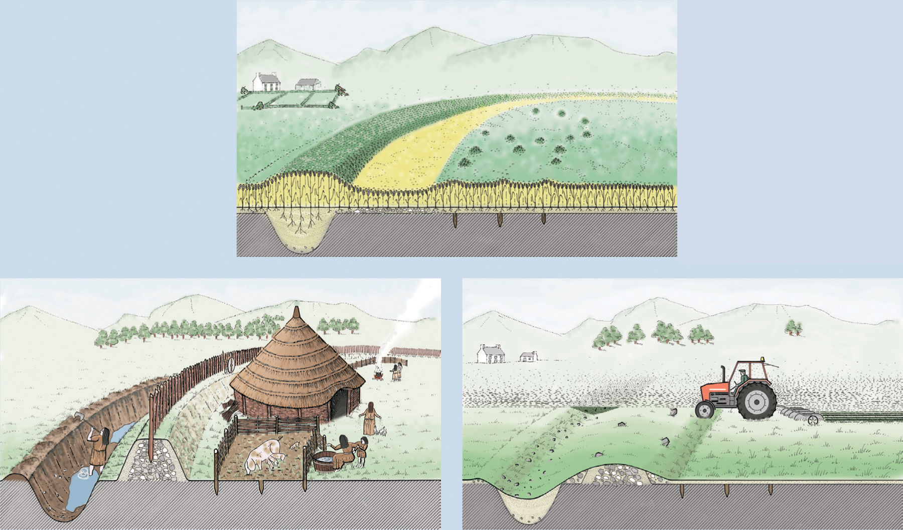
In some parts of the world, most archaeological sites have been leveled and now lie in arable land. Although these sites have suffered a degree of destruction (and many continue to be destroyed by annual cultivation), these landscapes can be rewarding when examined as aerial images. In summer months, certain crops may grow differently above different soils and above different depths of soil and can therefore indicate the presence of underlying archaeological and natural features. These crop differences, or crop-marks, have been the main media through which aerial survey has recorded the presence of archaeological features; indeed, more features have been discovered in this way than with any other form of prospection. The majority of crop-marks appear in cereal crops, but in drought conditions grass sometimes responds to differences below the ground, as at Stonehenge in July 2013 when parching showed previously unidentified stone holes that may have completed the sarsen circle (see Chapter 5).
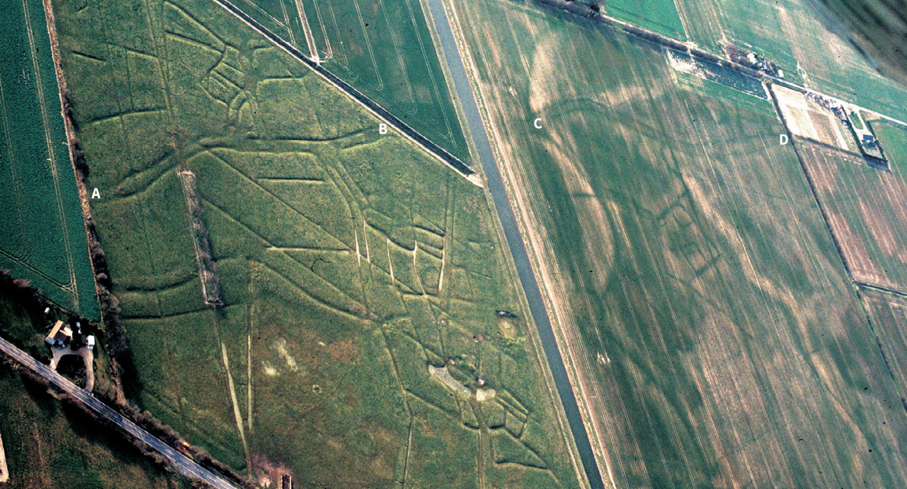
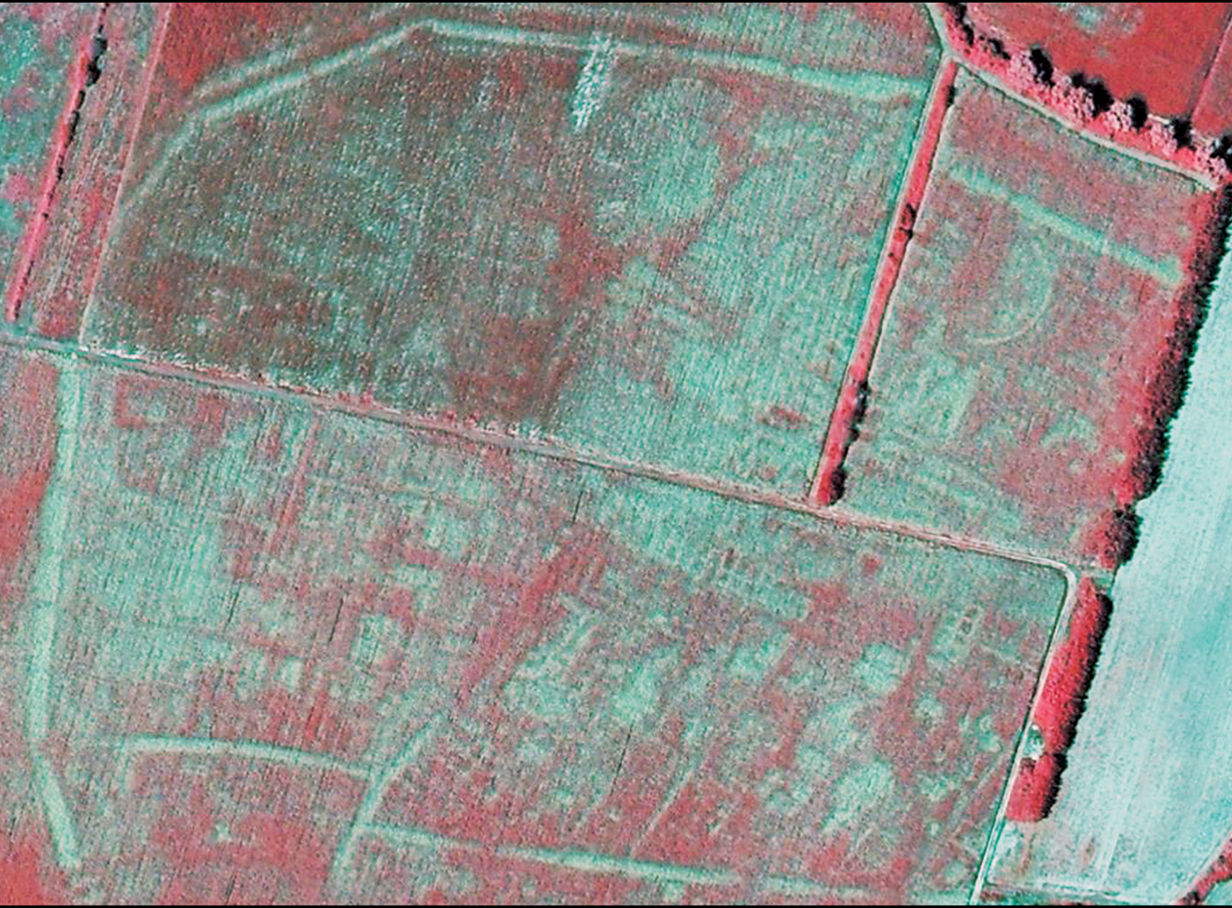
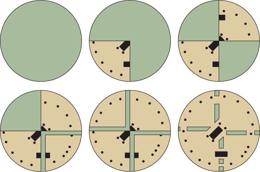
3.16 The simplified process of site formation. The drawing at top shows what may be visible today in a field that has been leveled by cultivation. Cereal crops respond to different depths of soil to produce “crop markings” that may be photographed from above. In an unplowed landscape (bottom right) the major elements of the site survive in slight relief. It is easier to see these from above or on the ground as a hollowed bank and a raised stony band where a former bank or rampart lay. From this evidence we have to imagine what type of features are represented by different crops or slight relief. The original site (bottom left) comprised of a bank and ditch surrounding a round house with its associated domestic stock pen and other fenced areas. Different aspects of the original site may be identified in relief and when it has been completely leveled, while some will never be recovered by this method of detection.3.17 Features in relief on the left of this oblique photograph reveal the subsurface remains of a Romano-British farm at Holbeach in the East Anglian fens of England. Ditches were cut to form field and property boundaries, define tracks, and drain the land. These features continue into the field on the right, which has been leveled and is now a cereal field. The track (A–B) that runs across the upper part of the left field can be seen to the right (C–D), marked by a darker band where crop growth has been boosted by the deeper soil that fills the former ditch. Silted channels of former watercourses show as broad light-toned bands where the crop is growing sparsely in poorer soil.3.18 The vanished Roman harbor town of Altinum, near Venice, was mapped in 2007 when a severe drought caused crop-marks to develop over buried structures. The unusual colors in this vertical image show it was taken in near-infrared wavelengths.
Drones or UAVs.
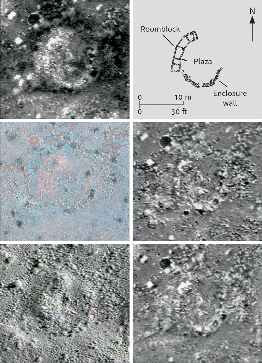
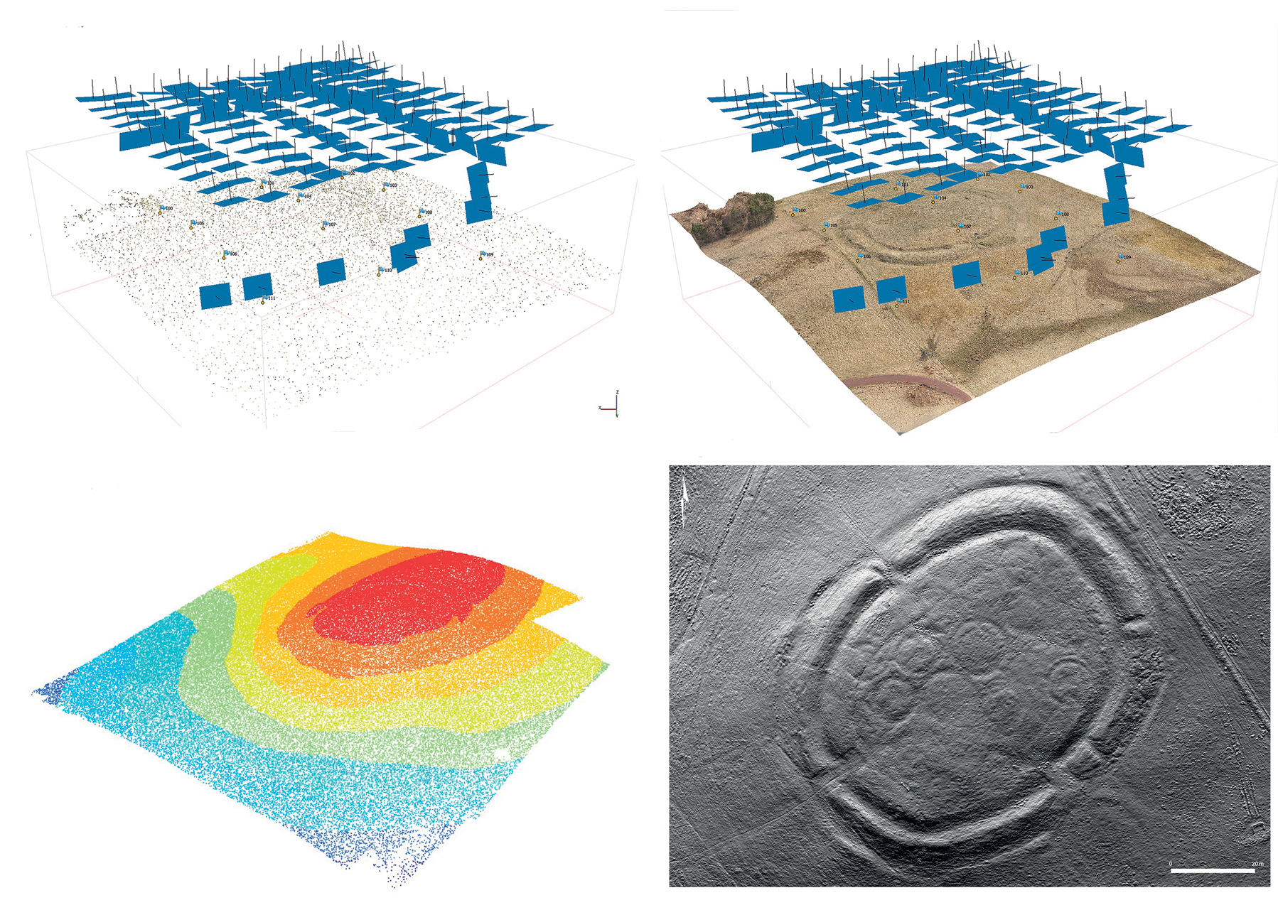
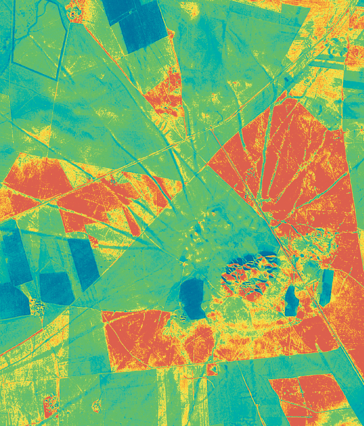
The use of drones (unmanned aerial vehicles) in combination with “structure from motion” (SfM) software for recording archaeological sites has become popular in archaeology. Small battery-powered drones carry a range of instruments and cameras and can be programmed to survey an area or take scores of pictures that produce an overlapping set, recording a site, feature, or excavation from all angles. SfM software can combine these images to produce a 3D model and, in so doing, create a set of “orthophotos”—geometrically corrected images representing an exact likeness of the earth—that can later be georeferenced and used for making accurate drawings. One recent experiment run by Jesse Casana and his colleagues used a drone carrying optical and thermal cameras to record parts of the Chaco-period (900–1180 CE) Blue J site in New Mexico. Flights followed a predetermined course synchronized with times of day when thermal responses were expected from different ground features. Images from each sensor were combined to produce an orthophoto mosaic that was tied to ground control points and could be precisely compared with others. The Blue J site is well known from ground and other survey, thus providing a good test environment for the method. The thermal imagery did reveal almost all the known archaeological features, suggesting that it could prove a useful tool in areas where similar remains might be expected.
3.19 A Chaco-period house compound at Blue J, New Mexico. Thermal imagery collected by a drone at 5:18 A.M.(upper left) reveals a roomblock, enclosure wall, and plaza area, all of which have been confirmed by conventional survey and test excavation (upper right). These features are not visible in a color photograph (center left), and are difficult to see through vegetation noise in thermal imagery from 9:50 P.M.(center right) or 6:18 A.M.(bottom right). Thermal imagery collected just after sunrise at 7:18 A.M.(bottom left) reveals the subtle topography of the house compound.3.20 The earthworks of the later prehistoric settlement at Braidwood, in southern Scotland, were documented by Historic Environment Scotland with photographs taken from a drone. Image-based modeling software first geometrically corrected the photographs to the appropriate scale and aligned them with a spare point cloud of coordinates of the landscape (top left). Texture was then added from the photos (top right). Finally, a dense point cloud of coordinates (bottom left) was used to produce a multi-direction hillshade model (bottom right).
LIDAR and SLAR.
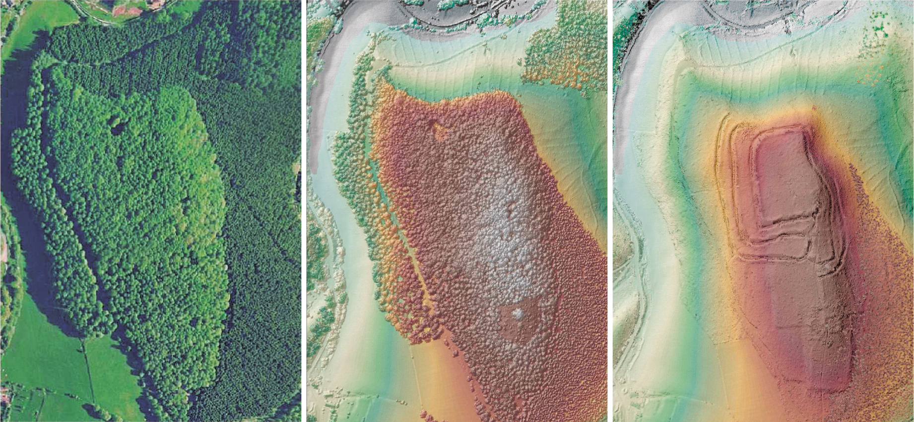
Use of LIDAR (light detection and ranging)—also known as ALS (airborne laser scanning)—has proved extremely valuable in the past few years. This technique uses an aircraft, the exact position of which is known through use of a differential GPS, carrying a laser scanner that rapidly pulses a series of beams to the ground. By measuring the time taken for these to return to the aircraft, an accurate 3D “point cloud” is created, which can be processed to produce precise digital elevation models (or digital surface models: DSMs) and a wide range of different visualizations of the data. LIDAR provides archaeologists with two great advantages over conventional aerial photography: tree canopies can be eliminated where the laser is able to penetrate to the ground surface through gaps in the vegetation; and the 3D terrain models can be visualized in many ways, simply by moving the angle and azimuth of the sun to enable ground features to be viewed under optimal (and sometimes naturally impossible) lighting. Both facilities have been used effectively in England where new sites—mostly enlargements to field systems—have been found, and locational corrections made to the existing record of the landscape around Stonehenge. A good example of the practical application of LIDAR to an archaeological site comes from the Maya city of Caracol in Belize (see box, p. 88). One variant of ALS, green LIDAR, can penetrate shallow water and has successfully been used to identify and record submerged remains in parts of the Mediterranean Sea.
Another remote sensing technique, sideways-looking airborne radar (SLAR), has yielded evidence suggesting that Maya agriculture was more intensive than previously imagined. The technique involves recording in radar images the return of pulses of electromagnetic radiation sent out from a flying aircraft. Since radar will penetrate cloud cover and to some extent dense rainforest, Richard Adams and his colleagues were able to use SLAR from a high-flying NASA aircraft to scan 80,000 sq. km (31,200 sq. miles) of the Maya lowlands. The SLAR images revealed not only ancient cities and field systems but also an enormous lattice of gray lines, some of which may have been canals, to judge by subsequent inspections by canoe. If field testing reveals that the canals are ancient, it will show that the Maya had an elaborate irrigation and water-transport system.
Satellite Imagery and Google Earth.
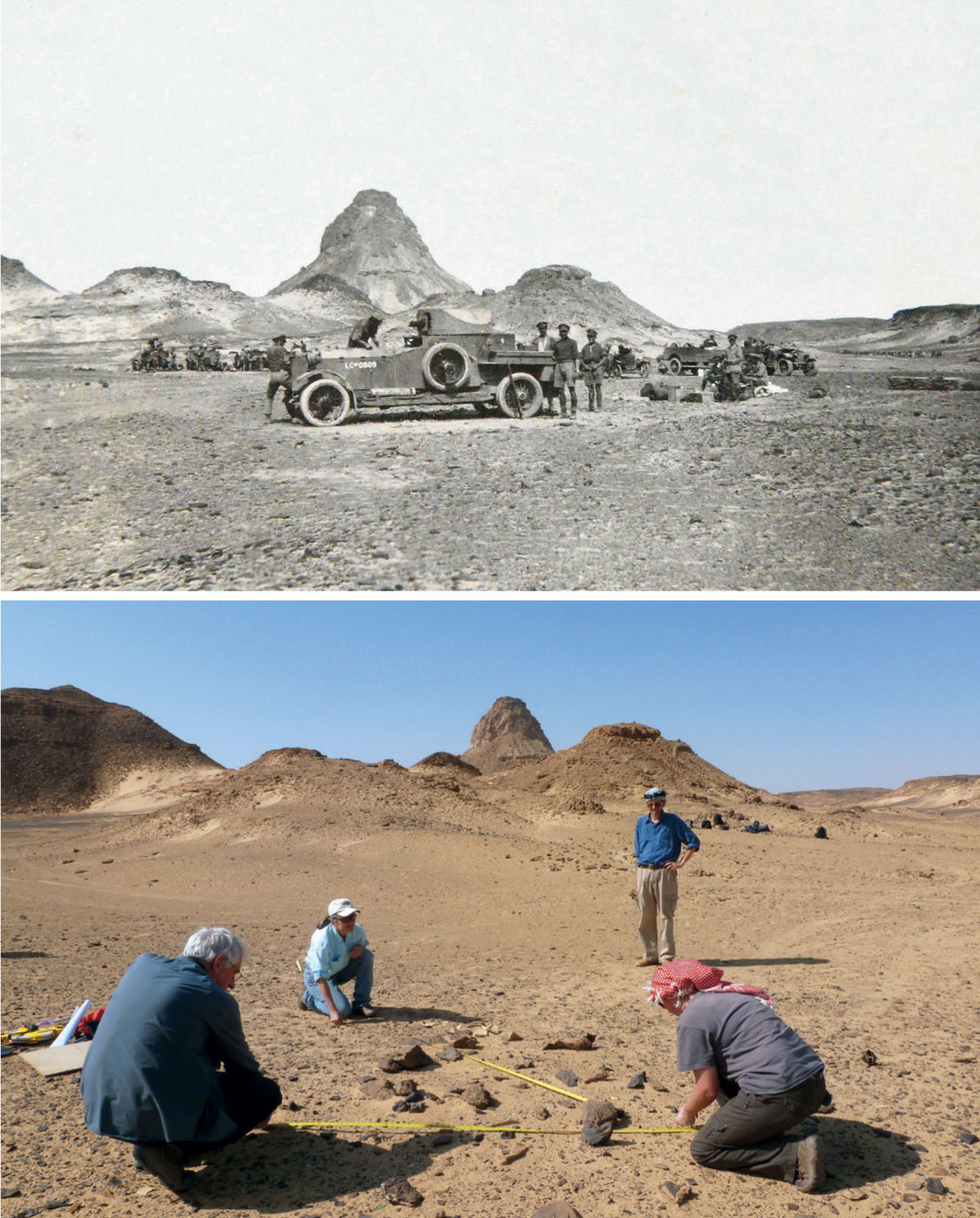
It is now routine to access Google Earth and use the high-resolution air photos and satellite cover there, or to buy copies of them. For example, a desert camp used by Lawrence of Arabia in World War I (1918) was recently located in Jordan as a result of Google Earth being used to examine a likely location shown in contemporary photographs.
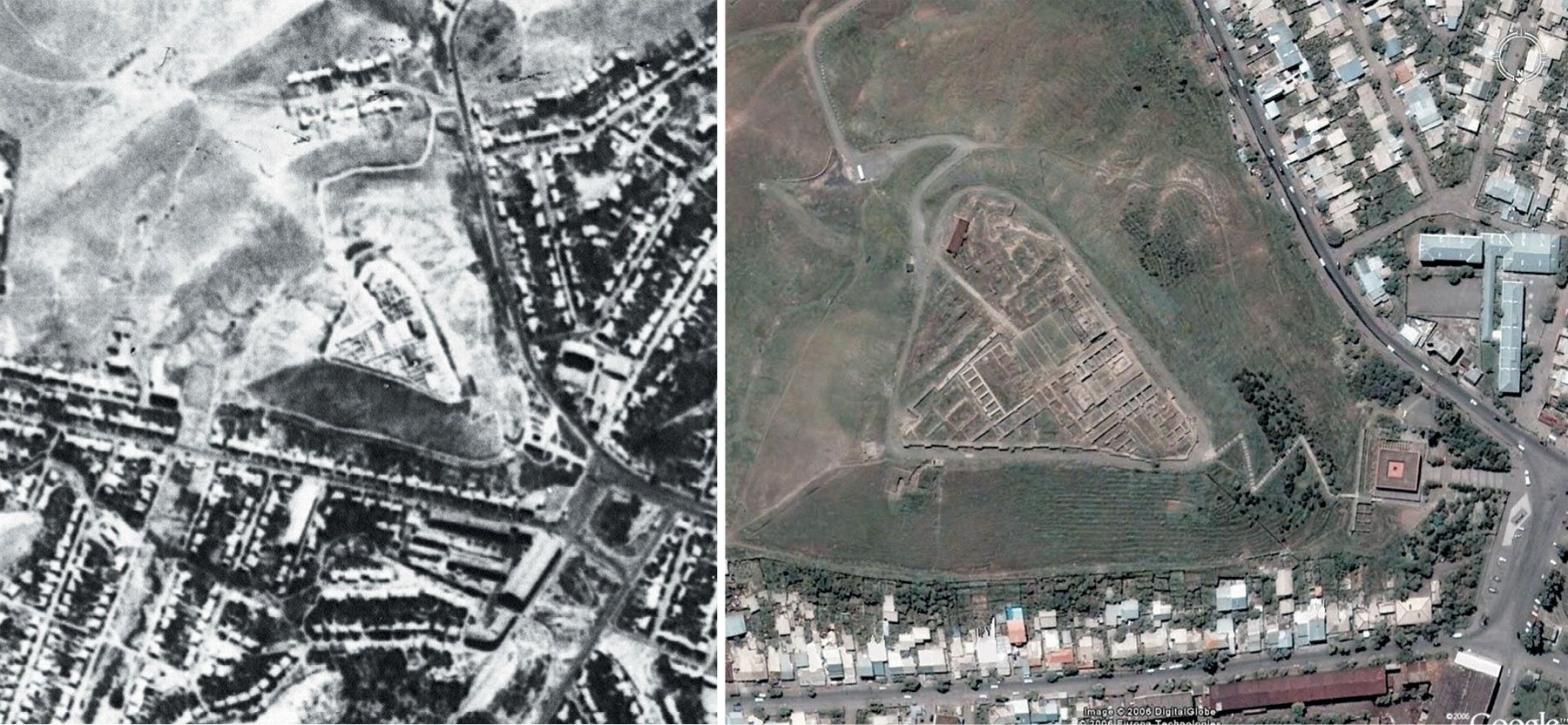
The high-resolution images publicly available from the IKONOS (about 1 m, 3 ft., resolution) and QuickBird (60 cm, 24 in.) satellites offer data comparable with aerial photographs, while Google Earth has basic world cover from NASA’s LANDSAT series (28.5 m, 94 ft.) but also incorporates IKONOS, QuickBird, and GeoEye images, some other satellite imagery, and conventional aerial photographs. IKONOS and QuickBird provide both multispectral (MS) and panchromatic (PAN) high-resolution imagery in which such details as buildings are easily visible. The imagery can be imported into remote sensing image-processing software, as well as into GIS packages for analysis.
Some useful early work was done using images from the LANDSAT series. Scanners record the intensity of reflected light and the infrared radiation from the earth’s surface, and convert these electronically into photographic images. LANDSAT images have been used to trace large-scale features such as ancient levee systems in Mesopotamia and an ancient riverbed running from the deserts of Saudi Arabia to Kuwait, as well as sediments around Ethiopia’s Rift Valley that are likely to contain hominin fossil beds.
The introduction of Google Earth has been a true “aerial revolution,” since it offers every archaeologist the opportunity to examine the ground and look for archaeological sites—for example, it is being used by paleontologists in Africa to hunt for fossils; in 2008 it revealed 500 new caves in South Africa alone, including the one that yielded the bones of Australopithecus sediba (see p. 167). Hundreds of new archaeological sites in Afghanistan and thousands of tombs in Saudi Arabia are also being discovered by this method. But the same “rules” of visibility apply to those images as to conventional aerial photos, and absence of evidence on one particular date is not evidence of absence. Microsoft’s Bing offers a more restricted range of aerial images, but these are sometimes different from those used in Google Earth and so complement this material. NASA’s World Wind also offers worldwide cover, but at lower resolutions or using aerial images available elsewhere. It is important to note, however, that most users have never been trained to interpret such images and many expect sites to be visible at all times.
3.21 LIDAR in operation: (left) the Iron Age hillfort of Welshbury in the Forest of Dean, England, is almost invisible in conventional aerial photographs. (Center) The initial LIDAR image shows little improvement; (right) but once reflections from leaves and trees (the “first return”) have been filtered out using a software algorithm, the earthworks are clearly visible.
Lasers in the Jungle
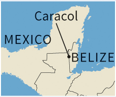
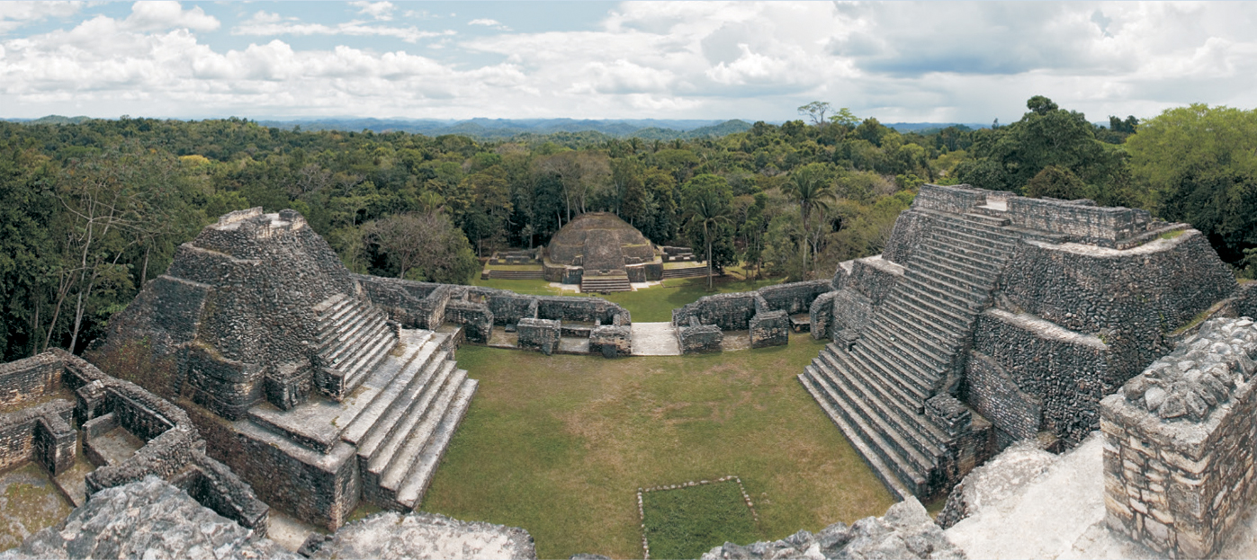
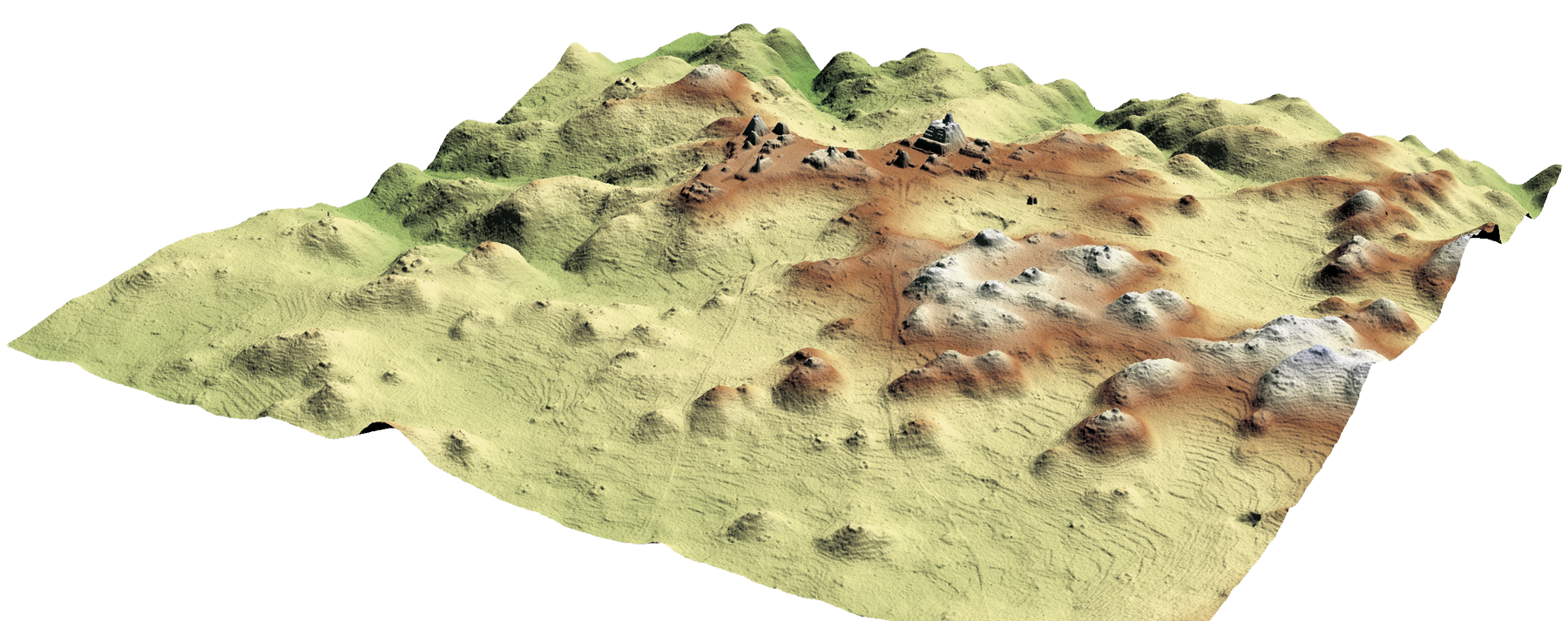
One of the best examples of the application of LIDAR (or ALS) to archaeology is at Caracol, a Maya city in Belize which flourished between 550 and 900 CE. Arlen and Diane Chase of the University of Central Florida have been excavating at this site for more than twenty-five years, and during that time researchers on the ground, despite the dense tropical forest, had managed to map 23 sq. km (9 sq. miles) of settlement. Survey from the air enabled them within a few weeks to surpass the results of those twenty-five years, by covering a far larger area and discovering that the city actually extended over 177 sq. km (68 sq. miles).
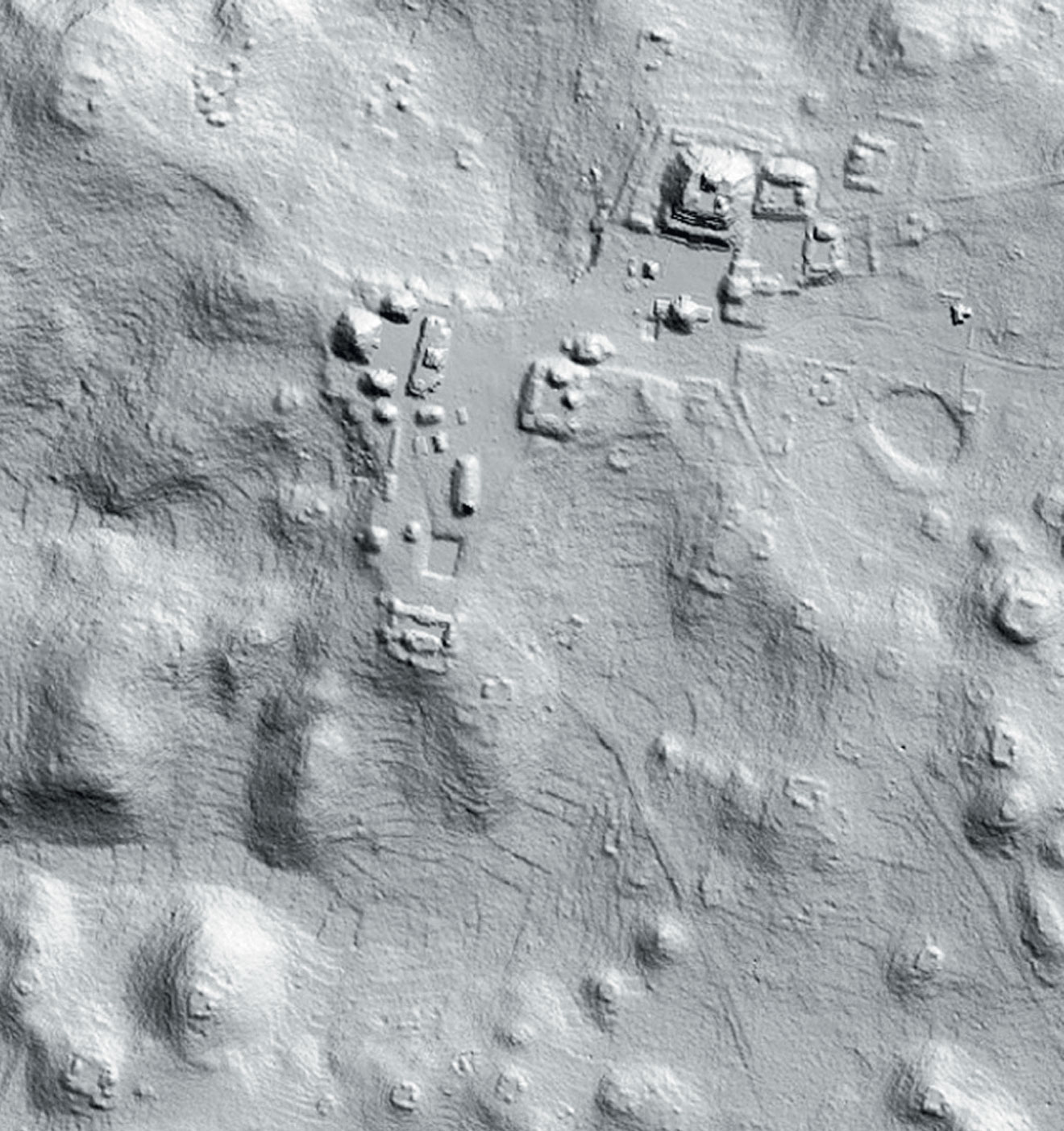
3.22 Plaza A at Caracol; only a tiny proportion of the city’s total area has been cleared.3.23 LIDAR image of the center of Caracol with jungle cover removed; agricultural terraces show up as ripples in valleys and hillsides.3.24 The plane’s route over its twenty-four hours of flight time, during which billions of measurements of the landscape were taken.3.25 The 3D projection of the Caracol LIDAR survey, showing the features beneath the canopy.
Biologist John Weishampel from the same university designed the project’s use of LIDAR. He had been using lasers to study forests and other vegetation for years, but this technique was now applied to the recording of an archaeological ruin under a tropical rainforest—the laser signals penetrate the jungle cover and are reflected from the ground below. Images taken at the end of the dry season in 2009 took about four days (twenty-four hours of flight time) to capture, the small aircraft passing back and forth over the city, and making more than 4 billion measurements of the landscape below. This was then followed by three weeks of analysis by remote sensing experts.
Caracol’s entire landscape can now be viewed in 3D, which has led to the discovery of new ruins, agricultural terraces, and stone causeways leading to more distant settlements. This was the first application of LIDAR to such a large archaeological site, and it is clear that the technique will radically transform research on sites in challenging environments of this kind. Although, just as excavation alone can verify the findings of ground-based remote sensing, so the data produced from the air at Caracol will need to be confirmed on the ground.
Both QuickBird and IKONOS images are stored in “libraries,” and can be accessed for a low cost. It is also possible to have photographs taken to order, although the minimum cost may be high. In parts of the world where maps are still considered confidential documents or do not exist, an up-to-date satellite image may be the only way to provide a base map for archaeological investigations.
Much use has been made of the Cold War CORONA satellite photographs (at best about 2 m, or 6 ft. 6in., resolution). These provide a useful base map and allow provisional interpretation of sites, which can later be checked by fieldwork. CORONA images have led to the detection and detailed mapping of numerous kinds of archaeological remains, such as ancient roads, ruins, and irrigation networks. CORONA takes two images of the same spot, which can be processed to produce a stereoscopic view and a 3D digital surface model.
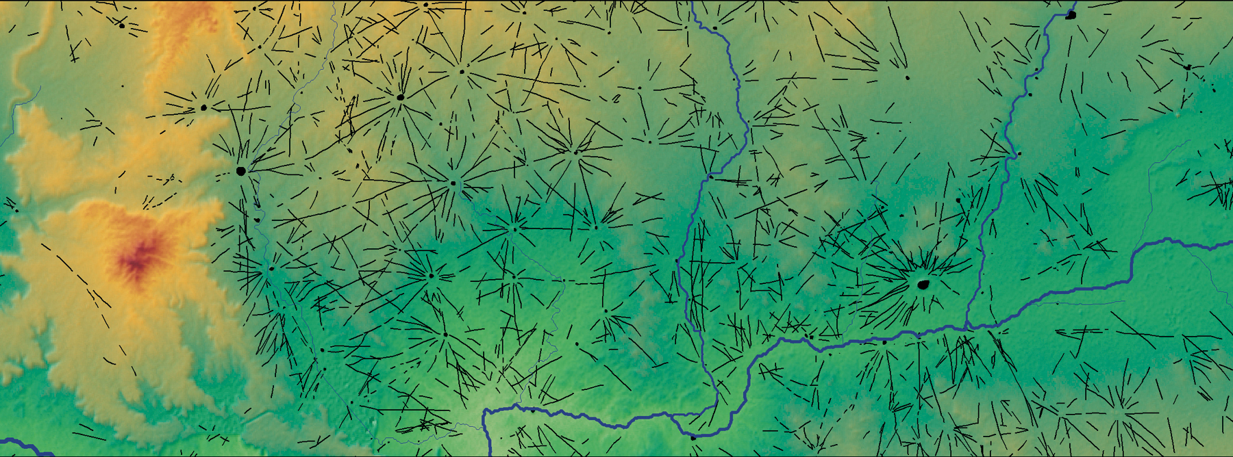
Jason Ur of Harvard University has used CORONA satellite photography to examine linear trackways across northern Mesopotamia (Syria, Turkey, and Iraq). These broad and shallow features (often called “hollow ways”) were formed over time as people walked from settlement to settlement, and from settlements to fields and pasture. Because depressed features collect moisture and vegetation, they are easily visible on CORONA images. Some 6,025 km (3,750 miles) of premodern features have been identified, primarily dating to a phase of Bronze Age urban expansion from around 2600 to 2000 BCE. Most commonly, trackways radiated out 2–5 km (1–3 miles) from sites in a spoke-like pattern. Although the region was home to several major centers, all intersite and interregional movement was through a chain of smaller settlements; no direct tracks existed between the major centers. Political centralization was probably weak, and authority was likely to have been consensual: even the elite had to respect local systems of land tenure as they moved about.
3.26–27 The black-and-white photograph above, together with Colonel T. E. Lawrence’s own writings, which refer to a “toothed hill” at which his team made camp, helped a Bristol University team to identify the site at which Lawrence stopped overnight while campaigning in northwestern Arabia.3.28–29 Two satellite images of the Urartian citadel of Erebuni, near Yerevan, Armenia, founded in 782 BCE: left, with resolution of about 2 m (10 ft.) is an image from the American CORONA series taken in 1971; right is a higher-resolution screenshot from Google Earth of a QuickBird image taken in 2006. Both are displayed with south to the top, so shadows assist photo-reading of topography and structures.3.30 Table summarizing the main techniques used in aerial survey.3.31 CORONA photograph (with false color added) of radial trackways around Tell Brak, northeastern Syria, dating from around 2600–2000 BCE.3.32 Thousands of miles of trackways in the region have been mapped by Jason Ur using a GIS database. The area shown is about 80 km (50 miles) wide. Tell Brak is at center right, north of the Khabur River.
Other Satellite Techniques.
Another recent addition to the archaeologist’s arsenal is SAR (synthetic aperture radar), in which multiple radar images (usually taken from space, but also from aircraft) are processed to yield extremely detailed high-resolution results that can provide data for maps, databases, land-use studies, and so forth. One of SAR’s many advantages is that, unlike conventional aerial photography, it provides results day or night and regardless of weather conditions. It can be used with multispectral data from satellites to make inventories of archaeological sites in a survey area—a rapid, non-destructive alternative to surface survey that does not involve the collection of artifacts and can therefore save a great deal of time and effort in some circumstances.
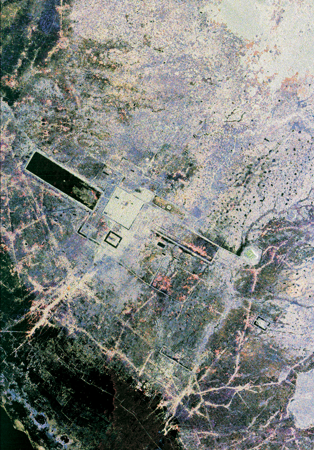
The international Greater Angkor Project has found that the vast ruins of the 1,000-year-old temple complex of Angkor in northern Cambodia may cover an area of up to 3,000 sq. km (1,150 sq. miles). The ruins, shrouded in dense jungle and surrounded by landmines left over from the civil war, have been the subject of studies using high-resolution radar imagery obtained from NASA satellites. The resulting dark squares and rectangles on the images are stone moats and reflective pools of water around the temples. The most important discovery for archaeologists so far has been the network of ancient canals surrounding the city (visible as light lines), which irrigated rice fields and fed the pools and moats. They were probably also used to transport the massive stones needed for constructing the complex. Recent LIDAR survey of this area has considerably supplemented the information derived from satellite sources.
ASTER (the Advanced Spaceborne Thermal Emission and Reflection Radiometer) is an imaging instrument that flies on Terra, a satellite launched in 1999 as part of NASA’s Earth Observing System (EOS), and is used to obtain detailed maps of land surface temperature, reflectance, and elevation. It goes beyond LANDSAT since it captures data in fourteen bands, from the visible to the thermal infrared wavelengths, and also provides a stereo viewing capability for the creation of digital elevation models. As the best ground resolution is 15 m (50 ft.), ASTER is useful for examination of terrain rather than for detecting sites, unless they are very large, such as the tell settlements typical in the Middle East.
The European Space Agency’s Sentinel-2 comprises two satellites capable of recording locations in the globe’s mid-latitudes every two to three days using multispectral sensors. Images are added to the ESA’s website and can be used to monitor crop development to help select optimal dates for commissioning higher-resolution aerial cover or to check vegetation cover prior to field survey visits.
Satellite remote sensing projects carried out by archaeologists with backgrounds in both remote sensing and archaeology have much to offer, but satellite archaeology should not be regarded as a substitute for archaeological excavation or survey work. It is just one among a number of tools that archaeologists may want to employ in their research. Besides revealing the presence of (sub)surface archaeological features (even in areas previously surveyed), satellite remote sensing can place archaeological sites in a much larger context, showing past social landscapes in all their complexity and helping greatly with quality assessment. Analysis of satellite imagery may further aid archaeologists in determining where to excavate and may precede archaeological survey. Archaeologists will need to persist in rethinking their surveying and excavation strategies in light of this new information, especially as image resolution continues to increase with technological advances.
3.33 A SAR satellite image of the huge ancient site of Angkor, Cambodia. The largest temple, Angkor Thom, is visible through the jungle cover as a large green square, with the smaller Angkor Wat beside it. The large dark rectangles are reservoirs.
Recording and Mapping Sites in Survey
As already noted in the discussion of aerial survey, the pinpointing of sites and features on regional maps is an essential next step in survey. To have discovered a site is one thing, but only when it has been adequately recorded does it become part of the sum total of knowledge about the archaeology of a region.
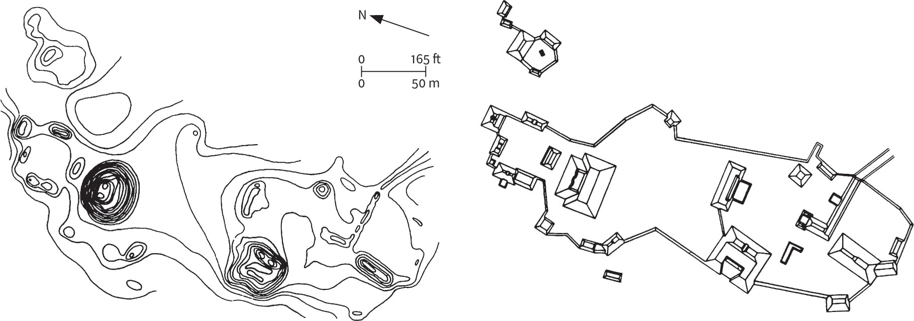
Mapping is the key to the accurate recording of most survey data. For surface features, such as buildings and roads, both topographic and planimetric maps are used. Topographic maps represent differences in elevation or height by means of contour lines and help relate ancient structures to the surrounding landscape. Planimetric maps exclude contour lines and topographic information, concentrating instead on the broad outlines of features, therefore making it easier, for example, to understand the relationship of different buildings to each other. On some site maps the two techniques are combined, with natural relief depicted topographically and archaeological features planimetrically.
In addition to plotting a site on a map—including its exact latitude, longitude, and map grid reference (or a metric UTM reference)—proper recording entails giving the site some kind of locational designation and entering this on a site record form, along with information about who owns the site, its condition, and other details. Locational designations vary in different parts of the world. In the United States, they usually consist of a two-digit number for the state, a pair of letters for the county, and a number indicating that this is the nth site discovered in that county. Thus site 36WH297 designates the 297th site discovered in Washington County (WH), in the state of Pennsylvania (36). This is the locational designation for the famous Paleoamerican Meadowcroft Rockshelter. One of the great values of designating sites using these alphanumerical systems is that the information can be entered easily on computer files, for quick data retrieval, for example in salvage archaeology or settlement-pattern studies.
3.34 Two ways of presenting survey results, as exemplified by these representations of the Maya site of Nohmul, Belize. A topographic map relating the site to its landscape. A planimetric map showing the individual features of the site.
Geographic Information Systems
The standard approach to archaeological mapping is now the use of GIS (geographic information systems), described in one official report as “the biggest step forward in the handling of geographic information since the invention of the map.” GIS are collections of computer hardware and software and of geographic data, designed to obtain, store, manage, manipulate, analyze, and display a wide range of spatial information. They combine a database with powerful digital mapping tools, and developed out of computer-aided design and mapping (CAD/CAM) programs during the 1970s. Some CAD programs, such as AutoCAD, can be linked to commercial databases and have proved valuable in allowing the automatic mapping of archaeological sites held in a computer database. A true GIS, however, also incorporates the ability to carry out a statistical analysis of site distribution, and to generate new information. Given information about slope and distance, for example, a GIS can also be used for cost-surface analysis, mapping catchment areas and site territories, taking the surrounding terrain into account. Here, the software and digital landscape information are fed into a computer, along with (as a standard measurement) the figure of one hour for a 5-km (3-mile) walk on the flat. The software then does the calculations, using built-in data on the energy cost of traversing different kinds of terrain. Therefore GIS have applications far beyond recording and mapping, and we shall return to their analytical capabilities in Chapters 5 and 6.
A GIS will hold information on the location and attributes of each site or point recorded. Spatial data can be reduced to three basic types: point, line, and polygon (or area). Each of these units can be stored along with an identifying label and a number of non-spatial attributes, such as name, date, or material. A single archaeological find might therefore be represented by an easting and northing coordinate and a find number, while an ancient road would be recorded as a string of coordinate pairs and its name. A field system could be defined as strings of coordinates following each field boundary, along with reference names or numbers. Each map (sometimes described in a GIS as a “layer” or “coverage”) may comprise a combination of points, lines, and polygons, together with their different non-spatial attributes.
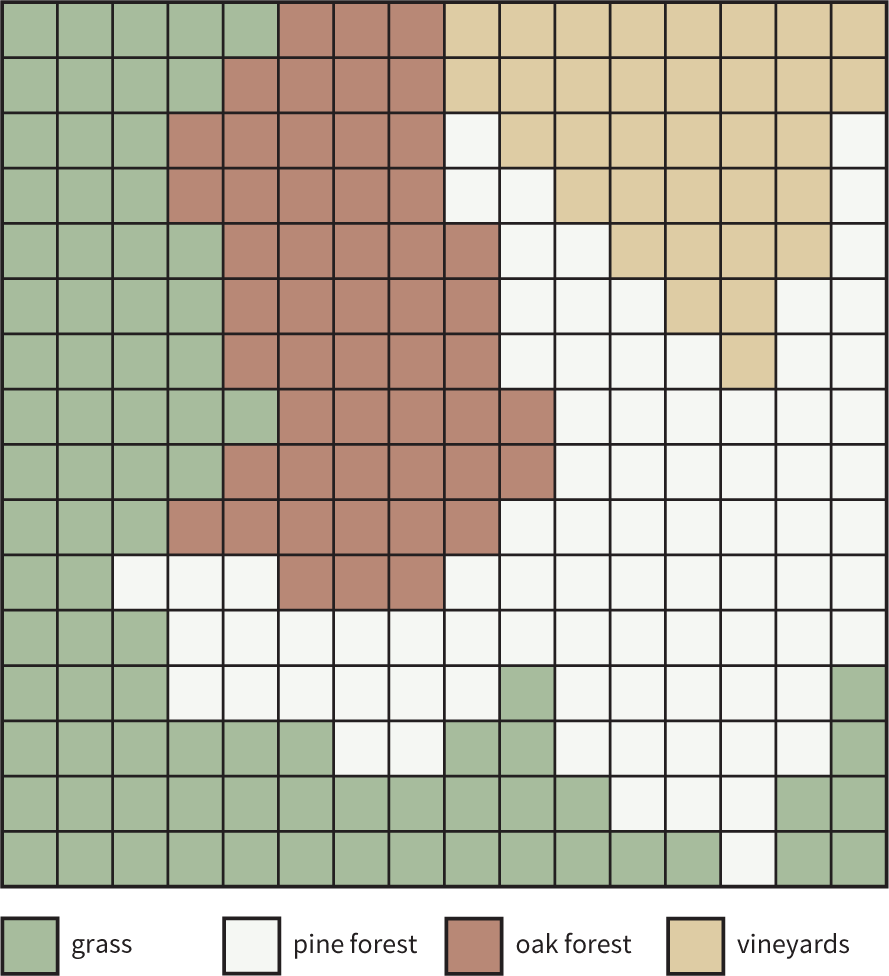
Within a map layer, the data may be held in vector format, as points, lines, and polygons, or they may be stored as a grid of cells, or raster format (see ill. 3.42). A raster layer recording vegetation, for example, would comprise a grid within which each cell contains information on the vegetation present at that point. Nowadays, most commercial systems will allow these different data structures to be mixed.
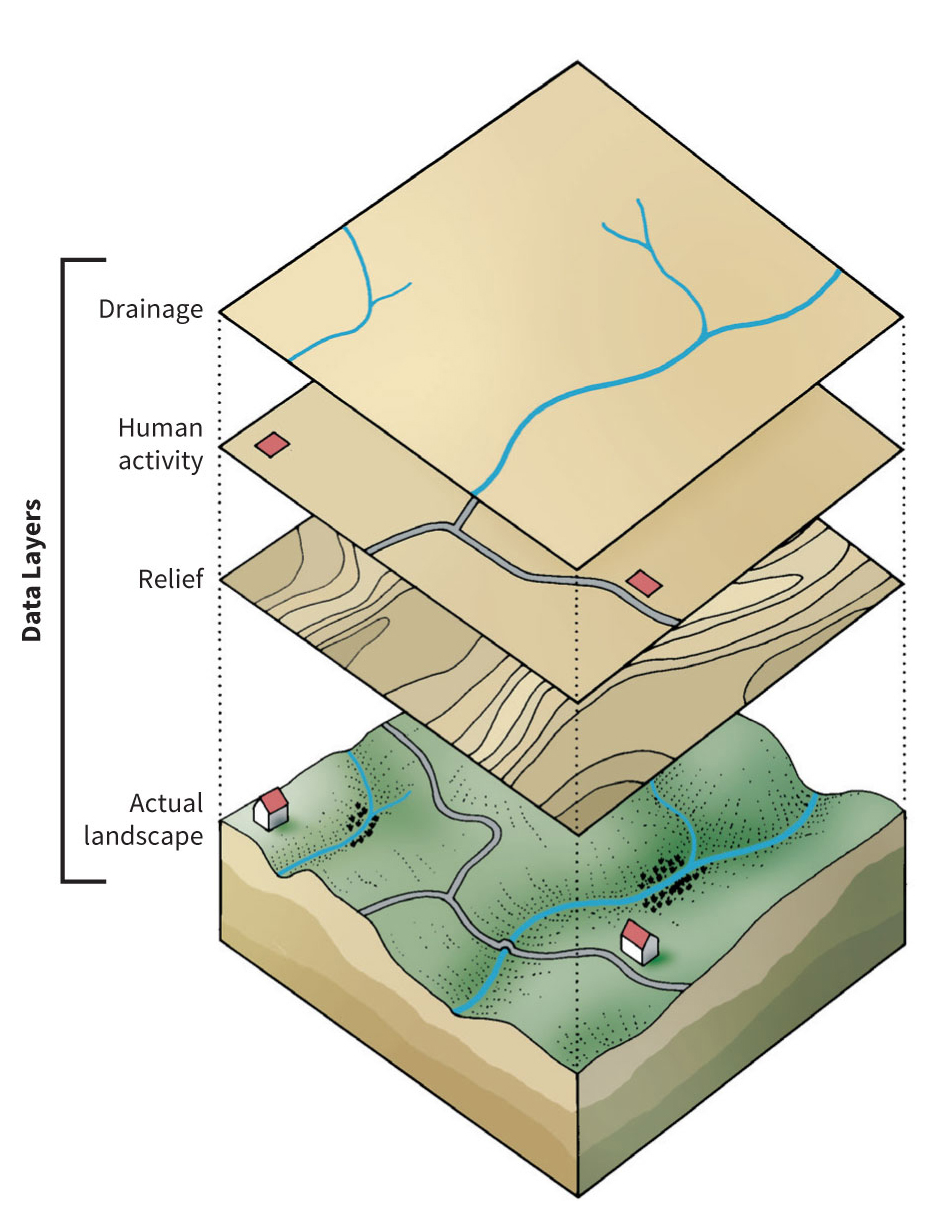
A GIS may include an enormous amount of environmental data on relief, communications, hydrology, etc. To make all this information easier to handle, it is normal to divide it into different map layers, each representing a single variable. Archaeological data may themselves be split into several layers, most often so that each layer represents a discrete “time-slice”. As long as they can be spatially located, many different types of data can be integrated in a GIS. These can include site plans, artifact distributions, aerial images, and geophysical survey results, as well as maps. A good example of many different types of data being incorporated into a GIS is the Giza Plateau Mapping Project in Egypt (see box pp. 94–95).
The ability to incorporate aerial images into a GIS can be particularly valuable for site reconnaissance as they can provide detailed and current land-use information. Many topographic data already exist in the form of digital maps which can be taken directly into a GIS. Knowing exact ground coordinates is essential in archaeological practice for mapping purposes, and learning about distribution patterns of archaeological material culture. This is done by means of a handheld GPS, which allows archaeologists to map their ground position (in some cases within as little as 3 cm, or 1 in.) by connecting to a global satellite system. A minimum of four satellites must be communicating with the GPS to provide precise x and y data, which can display the received information in longitude and latitude (degrees, minutes, seconds), or in a UTM coordinate system that provides data in eastings and northings. These data are extremely useful where a region is unmapped, or where the maps are old or inaccurate.
GIS and the Giza Plateau
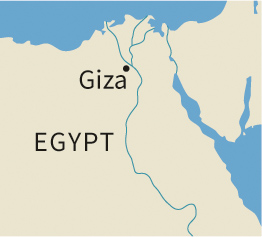
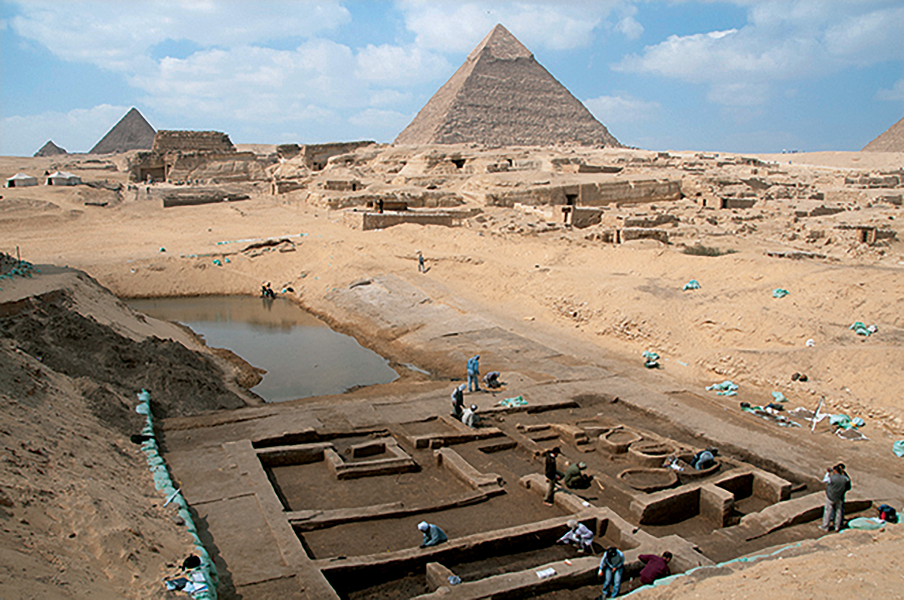
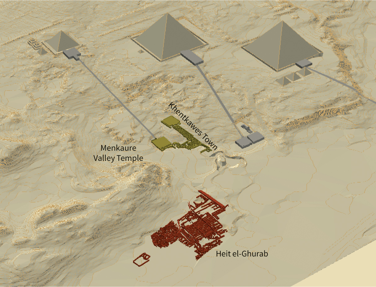
For nearly thirty years, American Egyptologist Mark Lehner has been systematically exploring a site at the edge of Egypt’s Giza Plateau that was home to the workforce that built the pyramids. This vast urban center is known as “Heit el-Ghurab” (Wall of the Crow) or “The Lost City of the Pyramid Builders.” Since 2005, Lehner’s Ancient Egypt Research Associates (AERA) have also been working southwest of the Sphinx in the area around the Menkaure Valley Temple and the town attached to the tomb of Queen Khentkawes.
Directed by Rebekah Miracle, AERA’s GIS is being used to integrate the project’s drawings, forms, survey data and artifact databases into a single organized digital archive. This enables the team to map patterns of architecture, burials, artifacts, and other materials, such as foodstuffs. For example, it appears that the residents of large houses ate the most desirable animal foods, beef from young cattle and Nile perch, while others ate predominantly sheep, goat, and pigs.
Eventually, AERA hopes to make all of these data available in an online database and GIS that can be accessed by researchers worldwide.
3.35 The Giza Plateau Mapping Project (GPMP) began with an extremely accurate survey of the cultural and natural features of the entire area. The survey grid is centered on the Great Pyramid.
Data collected over almost thirty years, all being incorporated in the GIS:
more than 19,000 archaeological features
more than 6,000 field drawings
survey and remote sensing data
aerial and satellite imagery
historical maps
artifact/ecofact distribution information
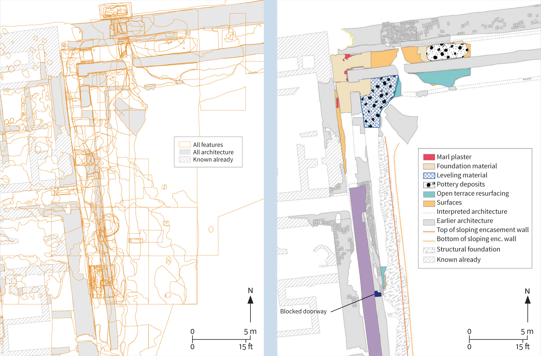
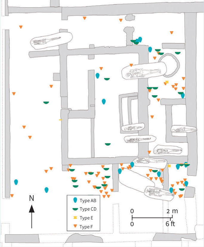
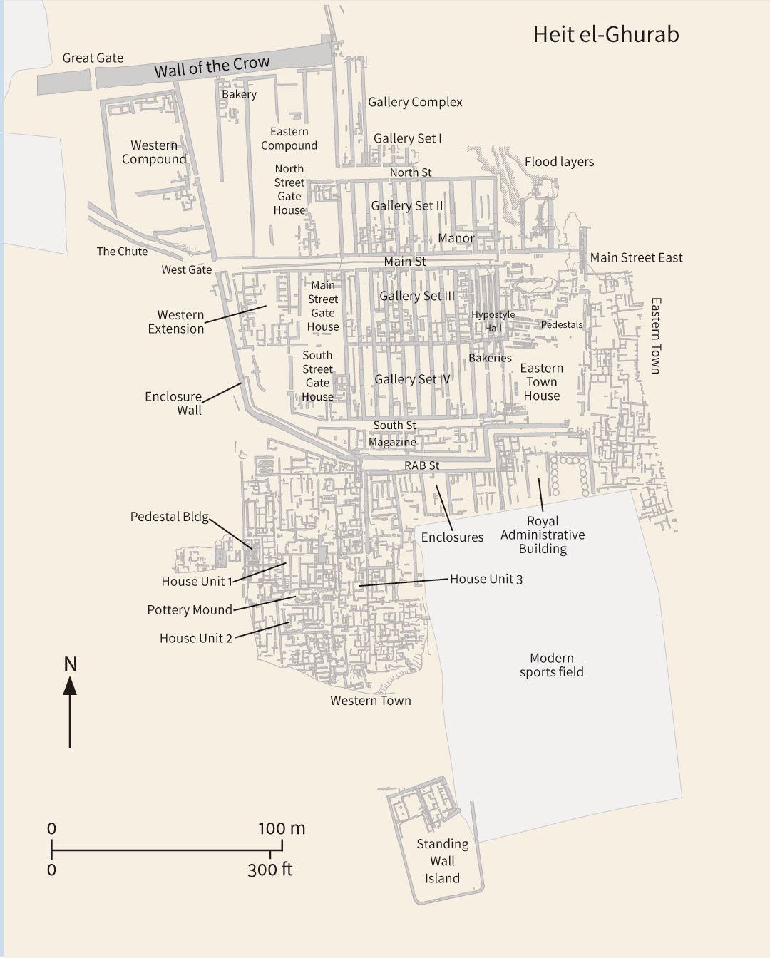
3.36 Using digitized 1-m (3-ft.) contours of the plateau and CAD data depicting the architectural components of the pyramid complex, the GPMP GIS team created a nearly three-dimensional surface called a TIN, or triangulated irregular network, over which they can lay other data layers, such as maps. Here (left), the GPMP survey grid is draped over the surface of the plateau. The Lost City of the Pyramid Builders is clearly visible in the foreground.3.37–38 GIS presentation of the features that have been digitally recorded in the Royal Administrative Building (RAB), one of the GPMP’s largest and most complex excavation areas.3.39 The spatial distribution of finds is easy to represent within the GIS. Here, the distribution of four different pottery types (shown in blue, GIS. Here, the distribution of four different pottery types (shown in blue, green, yellow, and orange) is displayed in an area of the Heit el-Ghurab settlement known as the Eastern Town House. Also displayed are later burials that have cut through the house’s walls.3.40 Since 1988 survey and excavations have been concentrated on the area known as Heit el-Ghurab, or The Lost City of the Pyramid Builders, some 400 m (1,300 ft.) south of the Sphinx. This detailed plan of the settlement, which was abandoned at the end of the 4th dynasty (2575–2465 BCE), the period of Giza pyramid building, now forms part of the GIS.
Once the basic outlines of a site have been mapped with reasonable accuracy by means of the GPS, and control points placed around the site, standard practice is to use a Total Station to record its more detailed features to a greater degree of accuracy. This instrument is an electronic theodolite integrated with an electronic distance meter, used to read distances to a particular point. Angles and distances are measured from the Total Station to points under survey and the coordinates (x, y, z, or northing, easting, and elevation) of the surveyed points relative to the Total Station positions are calculated. These data can then be downloaded from the Total Station to a computer to generate a map of the surveyed area. All the information is recorded and then submitted as GIS data to the client or sponsoring organization of the work as a matter of course.
Once data are stored within a GIS it is relatively straightforward to generate maps on demand, and to query the database to select particular categories of site to be displayed. Individual map layers, or combinations of layers, can be selected according to the subject under investigation. The ability of GIS to incorporate archaeological data within modern development plans allows a more accurate assessment of their archaeological impact.
One of the earliest, and most widespread, uses of GIS within archaeology has been the construction of predictive models of site locations. Most of the development has taken place within North American archaeology, where the enormous spatial extent of some archaeological landscapes means that it is not always possible to survey them comprehensively. The underlying premise of all predictive models is that particular kinds of archaeological site tend to occur in the same kinds of place. For example, certain settlement sites tend to occur close to sources of fresh water and on southerly aspects because these provide ideal conditions in which humans can live (not too cold, and within easy walking distance of a water source). Using this information, it is possible to model how likely a given location is to contain an archaeological site from the known environmental characteristics of that location. In a GIS this operation can be done for an entire landscape producing a predictive model map for the whole area.
3.41 Diagram showing possible GIS data layers.3.42 Raster representation of a data layer showing vegetation: each cell is coded according to the main vegetation type.
An example developed by the Illinois State Museum for the Shawnee National Forest in southern Illinois predicts the likelihood of finding a prehistoric site anywhere within the 91 sq. km (35 sq. miles) of the forest by using the observed characteristics of the sixty-eight sites, which are known from the 12 sq. km (4.6 sq. miles) that have been surveyed. A GIS database was constructed for the entire area including data themes for elevation, slope, aspect, distance to water, soil type, and depth to the water table. The characteristics of the known sites were compared with the characteristics of the locations known not to contain sites using a statistical procedure known as “logistic regression,” a probability model resulting in an equation that can be used to predict the probability that any location with known environmental characteristics will contain a prehistoric site.
The potential value of predictive modeling with GIS has also become apparent outside North America, particularly in the Netherlands and in Britain. Such models can be of value both in understanding the possible distribution of archaeological sites within a landscape, and also for the protection and management of archaeological remains in cultural resource management (see Chapter 15).
Many GIS applications, especially those based on predictive modeling, have been criticized as being environmentally deterministic, and it is easy to see why. Such data as soil types, rivers, altitude, and land use can be measured, mapped, and converted into digital data, whereas cultural and social aspects of landscape are much more problematic. In an attempt to escape from these more functionalist analyses, archaeologists have used the GIS function called viewsheds to try to develop more humanistic appreciations of landscape (see box pp. 186–87, and main text pp. 185 and 191).
Assessing the Layout of Sites and Features
Finding and recording sites and features is the first stage in fieldwork, but the next stage is to make some assessment of site size, type, and layout. These are crucial factors for archaeologists, not only for those who are trying to decide whether, where, and how to excavate, but also for those whose main focus may be site management or the study of settlement patterns, site systems, and landscape archaeology without planning any recourse to excavation.
We have seen how aerial images may be used to locate and plot the layout of sites. What are the other main methods for investigating sites without excavating them?
Site Surface Survey
The simplest way to gain some idea of a site’s extent and layout is through a site surface survey—by studying the distribution of surviving features, and recording and possibly collecting artifacts from the surface.
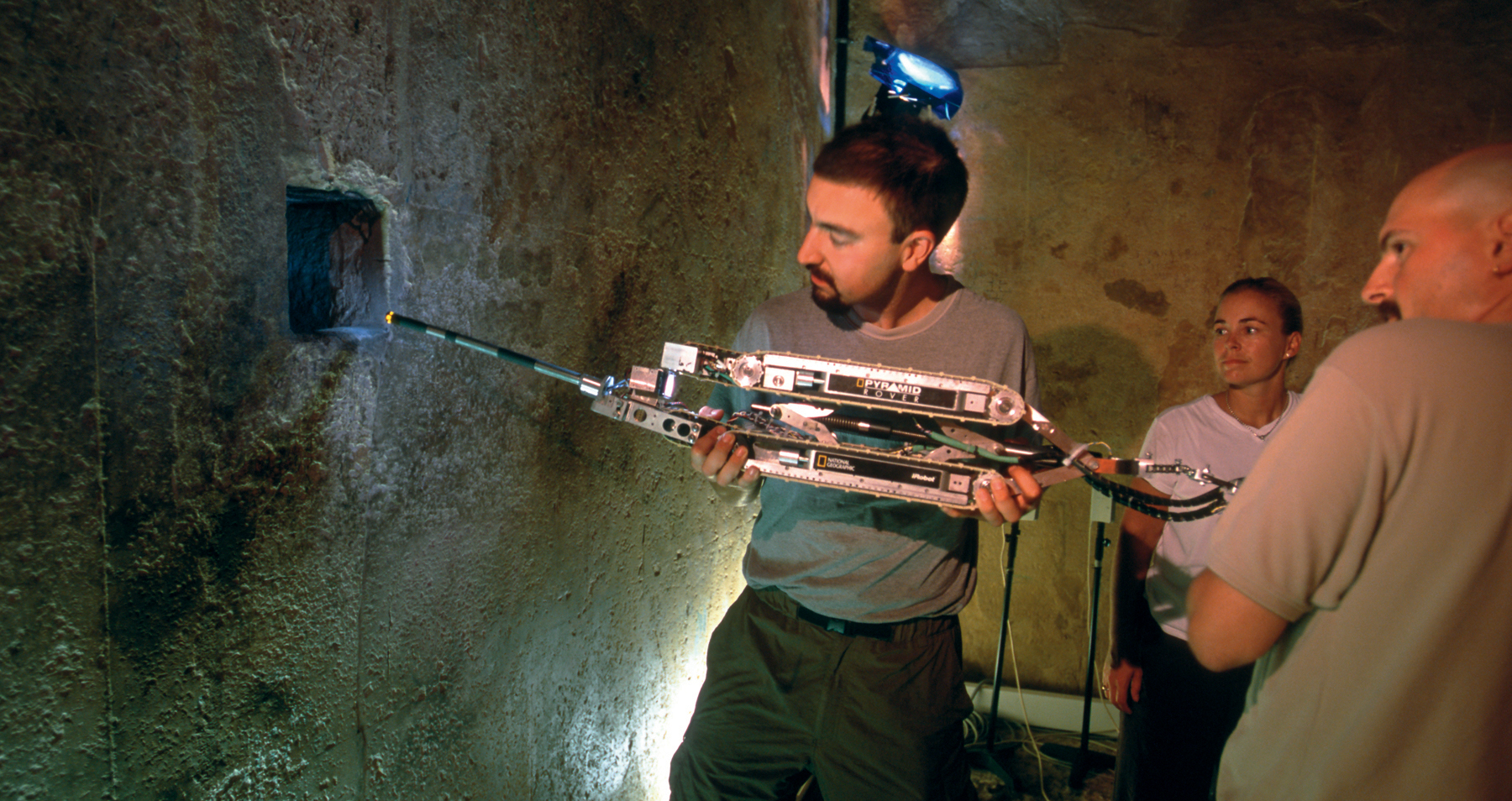
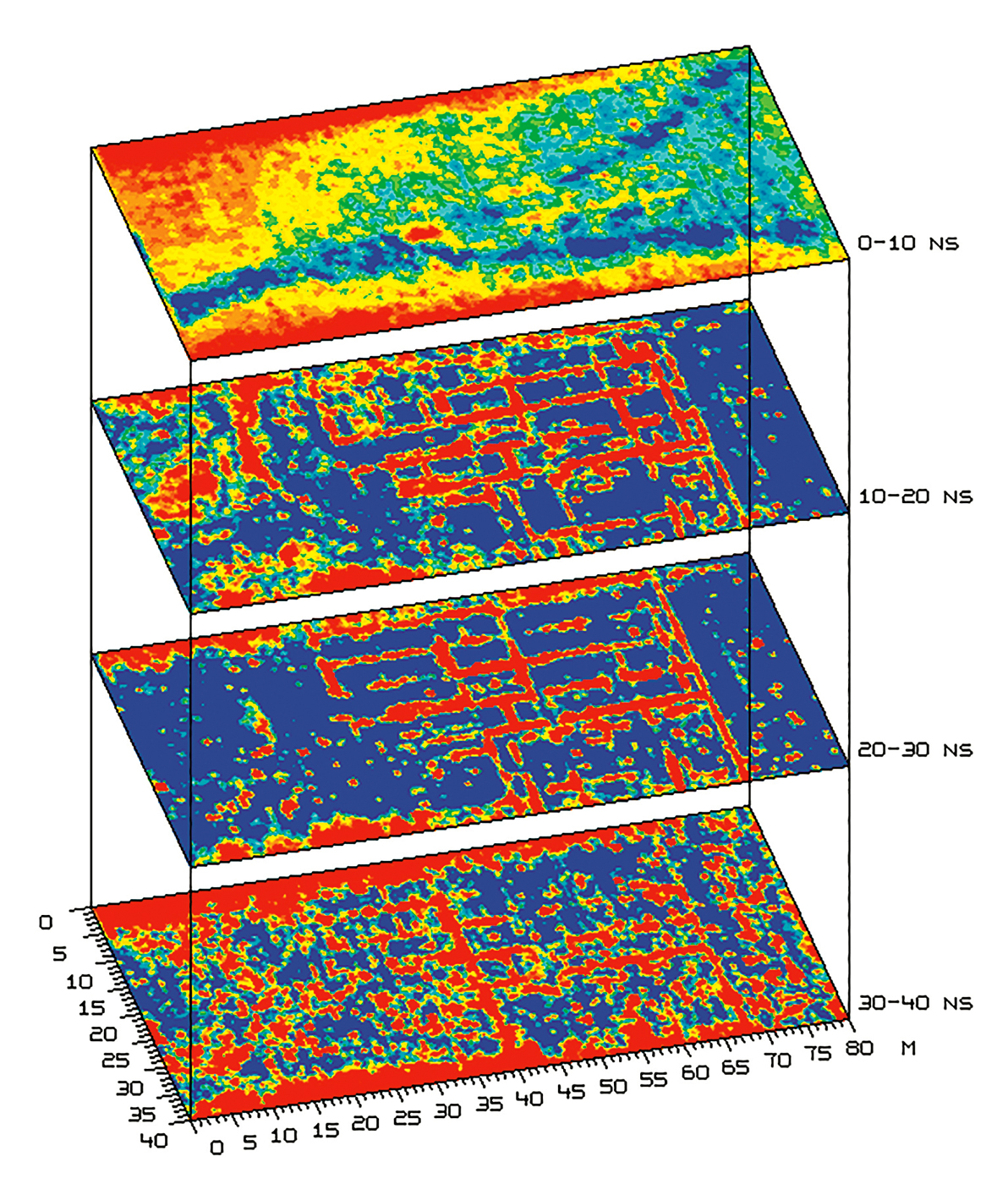
The Teotihuacán Mapping Project, for instance, used site surface survey to investigate the layout and orientation of the city, which was the largest and most powerful urban center in Mesoamerica in its heyday from 200 to 650 CE. The layout and orientation of the city had intrigued scholars for decades; however, they considered the grandiose pyramid-temples, plazas, and the major avenue—an area now known as the ceremonial center—to be the entire extent of the metropolis. It was not until the survey conducted by the Teotihuacán Mapping Project that the outer limits, the great east–west axis, and the grid plan of the city were discovered and defined. Fortunately, structural remains lay just beneath the surface, so that the team were able to undertake the mapping from a combination of aerial and surface survey, with only small-scale excavation to test the survey results. Millions of potsherds were collected, and more than 5,000 structures and activity areas recorded. Since 1980, a team from the Mexican Institute of Archaeology and History (INAH) has been enlarging the picture so successfully established by the Teotihuacán project survey. Other teams employed geophysical methods to map a system of caves and tunnels used for extracting construction material, as well as for burials and rituals. Magnetometer and resistivity surveys (see pp. 102–3), undertaken by a team from the National Autonomous University of Mexico led by Linda Manzanilla, were used to create a 3D reconstruction of subsurface contours.
For artifacts and other objects collected or observed during surface survey, it may not be worth mapping their individual locations if they appear to come from badly disturbed secondary contexts. Or there may simply be too many artifacts realistically to record all their individual proveniences. In this latter instance, the archaeologist will probably use sampling procedures for the selective recording of surface finds. Where time and funds are sufficient and the site is small enough, however, collection and recording of artifacts from the total site area may prove possible. For example, Frank Hole and his colleagues picked up everything from the entire surface of a 1.5-ha (3.7-acre) open-air prehistoric site in the Valley of Oaxaca, Mexico, plotting locations using a grid of 5-m (16-ft.) squares. They transformed the results into maps with contour lines indicating not differences in elevation but relative densities of various types of materials and artifacts. It then became clear that, although some objects (such as projectile points) were evidently in a secondary context displaced down slopes, others seemed to lie in a primary context and revealed distinct areas for flintworking, seed-grinding, and butchering. These areas served as guides for subsequent excavation.
Tell Halula: Multi-Period Surface Investigations
Surface investigations by Australian archaeologist Mandy Mottram at Tell Halula in northern Syria in 1986 aimed to establish the occupation history of this multi-period site by identifying the different cultures represented as well as the location and extent of their settlements. Earlier investigations of the site using non-probabilistic sampling (based on the judgment of the sampler) methods implied a principal occupation during the Halaf period, c. 5900–5200 BCE, followed by several lesser occupations. The subsequent discovery of materials belonging to a preceramic phase of the Neolithic suggested that the occupation history of the site might be far more complex than hitherto suspected.
After the extent of the site had been determined, artifacts such as potsherds and stone tools were collected from the surface using stratified random sampling procedures based on a grid system. Forty-six squares in this grid were sampled, amounting to 4 percent of the 12.5-ha (31-acre) site area. Typological analysis of the artifacts enabled Mottram to identify ten major occupation phases, representing fifteen different cultural periods. The presence of transitional-type artifacts indicated that occupation was often continuous from one phase to another, testifying to long-term political and economic stability.
3.43 The survey and collecting team at Tell Halula using a theodolite.3.44 CORONA satellite image of the Halula district, showing the location of the tell and the boundary of the sampling area.
To establish where the different settlements were located on the tell, GIS software was used to map the distribution of artifacts belonging to each occupation phase. The resulting contour maps of artifact density were then overlaid on a relief map of the site and on each other, enabling the distributions to be interpreted in the light of both surface topography and the probable stratigraphic relations of the parent deposits. Integral to this process was the application of a “noise” estimate, which helped to screen out materials likely to have reached their current locations as a result of random rather than long-term processes.
Results of the Survey
As well as indicating the number, size, and chronology of the different settlements, an important result of this work was the identification of some of the processes involved in the mound’s formation and how these affected what remained on the surface. One important discovery was that the site was originally composed of two tells—one in the southeast and the other in the north and west. The maps also revealed that the site is severely eroded, a situation evidently exacerbated in recent times by clearance of surface architecture.
The later occupation deposits have been severely degraded, leaving earlier levels widely exposed. Many of the later settlements are therefore likely to have been more extensive than is indicated by any remains. At the same time, it is now certain that the site was most extensively occupied during the Pre-Pottery Neolithic, dating to c. 7900–6900 BCE, rather than during the Halaf period, as previously thought.
Another important discovery was that the site was only finally abandoned at the end of the Hellenistic (or start of the Roman) period—in around 60 BCE. All later materials were found to be the product of manuring of the area by the inhabitants of an adjacent site, indicating that, over the last two millennia or more, Tell Halula’s main use has been as agricultural land.
It thus proved possible from surface survey, combined with GIS, to obtain a clearer understanding of the complex occupation sequence of this multi-period site and reveal previously unknown details of its history.
3.45 Plan of Tell Halula showing the layout of collection squares, plus outline plans of the tell showing the changing location and size of settlement during five of the ten occupation phases.
A similar surface survey was conducted at the Bronze Age city of Mohenjodaro in Pakistan. Here, a team of archaeologists from Pakistan, Germany, and Italy investigated the distribution of craft-working debris and found, to their surprise, that craft activities were not confined to a specific manufacturing zone within the city, but were scattered throughout the site, representing assorted small-scale workshops.
Reliability of Surface Finds.
Archaeologists have always used limited surface collection of artifacts as one way of trying to assess the date and layout of a site prior to excavation. Now that surface survey has become not merely a preliminary to excavation but in some instances a substitute for it—for cost and other reasons, as outlined earlier in this chapter—a vigorous debate is taking place in archaeology about how far surface traces do in fact reflect distributions below ground.
We would logically expect single-period or shallow sites to show the most reliable surface evidence of what lies beneath—an assumption that seems to be borne out by the shallow site of Teotihuacán, or Frank Hole’s Oaxaca site mentioned above. Equally, we might predict that multi-period, deep sites such as Near Eastern tells or mounds would show few if any traces on the surface of the earliest and deepest levels. Yet this is by no means always true, as shown by surface survey work at Tell Halula in Syria (see box on left).
Proponents of the validity of surface survey, while agreeing that there is bound to be a quantitative bias in favor of the most recent periods on the surface, nevertheless point out that one of the surprises for most survey archaeologists is how many of their sites, if examined with care, are truly multi-period, reflecting many phases of a site’s use, not just the latest one. The reasons for this certainly have something to do with the kind of formation processes discussed in Chapter 2—from erosion and animal disturbance to human activity such as plowing.
The relationship between surface and subsurface evidence is undoubtedly complex and varies from site to site. It is therefore wise, wherever possible, to try to determine what really does lie beneath the ground, perhaps by digging test pits (usually 1-m, or 3-ft., squares) to assess a site’s horizontal extent, or ultimately by more thorough excavation (see pp. 108–26). There are, however, a whole battery of subsurface detection devices that can be brought into play before—or indeed sometimes instead of—excavation, which of course is destructive as well as being expensive to undertake.
3.46 Archaeological and topographic map of Teotihuacán produced by the Teotihuacán Mapping Project. The survey grid system of 500-m (1,650-ft.) squares is oriented to the north–south axis of the city, in particular the central “Street of the Dead” (dividing W1 and E1 on the map).3.47 View south along the Street of the Dead, with the Pyramid of the Sun prominent on the left, echoing the shape of the mountain behind.
Subsurface Detection
Probes.
The most traditional technique is that of probing the soil with rods or augers and noting the positions where they strike solids or hollows. Metal rods with a T-shaped handle are the most common, but augers—large corkscrews with a similar handle—are also used, and have the advantage of bringing samples of soil to the surface, clinging to the screw. Many archaeologists routinely use handheld probes that yield small, solid cores. Probing of this type was used, for example, to gauge the depth of the midden at the Ozette site in Washington State (pp. 60–61) and by Chinese archaeologists to plot the hundreds of pits remaining to be investigated near the first emperor’s famous buried terracotta army. In the mid-1980s, the American archaeologist David Hurst Thomas and his team used more than 600 systematically spaced test probes with a gasoline-powered auger in their successful search for a lost sixteenth-century Spanish mission on St. Catherine’s Island off the coast of Georgia in the US. Augers are also used by geomorphologists studying site sediments. However, there is always a risk of damaging fragile artifacts or features.
One notable advance in this technique was developed by Carlo Lerici (1890–1981) in Italy in the 1950s as part of the search for Etruscan tombs of the sixth century BCE. Having detected the precise location of a tomb through aerial photography and soil resistivity (see below), he would bore down into it a hole 8 cm (3 in.) in diameter, and insert a long tube with a periscope head and light, with a tiny camera attached if needed. Lerici examined some 3,500 Etruscan tombs in this way, and found that almost all were completely empty, saving future excavators a great deal of wasted effort. He also discovered more than twenty with painted walls, therefore doubling the known heritage of Etruscan painted tombs at a stroke.
Probing the Pyramids.
Modern technology has taken this kind of work even further, with the development of the endoscope (see Chapter 11) and miniature TV cameras. In a project reminiscent of Lerici, a probe was carried out in 1987 of a boat pit beside the Great Pyramid of Khufu (Cheops), in Egypt. This lies adjacent to another pit, excavated in 1954, which contained the perfectly preserved and disassembled parts of a 43-m (141-ft.) long royal cedarwood boat of the third millennium BCE (see p. 334). The 1987 probe revealed that the unopened pit did indeed contain all the dismantled timbers of a second boat. In 2008 a team from Waseda University inserted a second miniature camera to re-examine the boat’s condition and ascertain whether it could be safely lifted. The covering stone blocks and the boat’s timbers were duly removed in 2011.
Robot probes with miniature cameras have been sent up the so-called “airshafts” of the Great Pyramid to discover whether or not they link up to hidden chambers. For example, the Pyramid Rover was able to reach and drill through a previously discovered stone slab blocking one of these shafts, revealing another doorway behind. Further probes have been used by French and Japanese teams who believe the Pyramid may contain as yet undiscovered chambers or corridors; using ultrasensitive microgravimetric equipment—normally employed to search for deficiencies in dam walls, as it can tell if a stone has a hollow behind it—they detected what they think is a cavity some 3 m (10 ft.) beyond one of the passage walls. Test drilling to support this claim, however, has not been completed. All tests are carefully monitored by the Egyptian authorities until their potential contribution to Egyptology has been established. Projects of this kind are beyond the resources of most archaeologists. But in future, funds permitting, probes of this type could equally well be applied to other Egyptian sites, to cavities in Maya structures, or to the many unexcavated tombs in China.
3.48 Robots were first used to explore and clear the Great Pyramid’s “airshafts” in 1993. In 2002 the Pyramid Rover re-entered two of these shafts for more thorough investigation, navigating turns that the previous unit could not.
Ground-Based Remote Sensing
Probing techniques are useful, but inevitably involve some disturbance of the site. There is, however, a wide range of non-destructive techniques ideal for the archaeologist seeking to learn more about a site before—or increasingly often without—excavation. These are geophysical sensing devices that measure energies and properties in the soil in order to “read” what lies below the surface. These energies and properties may be natural magnetism and gravity, or waves passed through the soil manually by the archaeologist.
Seismic and Acoustic Methods.
Some types of echo-sounding, such as sonar, have been employed in archaeology. For example, detection of anomalies can find cavities such as caves. Seismic methods normally used by oil prospectors have helped to trace details of the foundations of St. Peter’s Basilica in the Vatican in Rome.
One of the most important archaeological applications of echo-sounding techniques, however, is in underwater projects (see box p. 114). In one case, after a bronze statue of an African boy was brought up in a sponge-diver’s net off the Turkish coast, George Bass and his colleagues were able to locate the Roman ship from which it came by means of echo-location systems. The use of multibeam sonar can gather huge amounts of data from wreck sites for the creation of 3D terrain models; it covers the seabed below and to either side of the survey vessel, and derives continuous and well-positioned spot heights for thousands of points on the seabed as the vessel moves forward.
Electromagnetic Methods.
A basically similar method, which employs not sonic but radio pulses, is ground-penetrating (or probing) radar (GPR). An emitter sends short pulses through the soil, and the echoes not only reflect back any changes in the soil and sediment conditions encountered, such as filled ditches, graves, walls, etc., but also measure the depth at which the changes occur on the basis of the travel time of the pulses. Three-dimensional maps of buried archaeological remains can then be produced from data-processing and image-generation programs.
In archaeological exploration and mapping, the antenna is towed by a vehicle or dragged manually along the ground, sending out and receiving many pulses per second. The measurements are collated into a 3D model. One advance of such models is the use of “time-slices” or “slice-maps.” Thousands of individual reflections are combined into a single three-dimensional dataset which can then be “sliced” horizontally, each slice corresponding to a specific estimated depth in the ground, and revealing the general shape and location of buried features at successive depths. For example, in the Forum Novum, an ancient Roman marketplace located about 100 km (60 miles) north of Rome, British archaeologists from the University of Birmingham and the British School of Archaeology in Rome needed a fuller picture of an unexcavated area than they had been able to obtain from aerial photographs and other techniques such as resistivity (see below). A series of GPR slices of the area revealed a whole architectural layout of the site which means that future excavation can be concentrated on a representative sample of the structures, avoiding a costly and time-consuming uncovering of the whole area.
Parts of the fourth-largest Roman city in England, that of Wroxeter in Shropshire (see box pp. 104–5), have been studied by GPR as well as other geophysical methods; “time-slices” from different depths have revealed the town’s changing history through 400 years.
In Japan, a burial mound at Kanmachi Mandara of about 350 CE was protected from excavation by cultural property laws, so GPR was used to locate the burial area within the mound, and determine its structural design. Radar profiles were taken at 50-cm (20-in.) intervals across the mound, with pulses that could penetrate about 1 m (3 ft.) into the ground.
Earth Resistance Survey.
A commonly used method that has been employed on archaeological sites for several decades, is electrical resistivity. The technique derives from the principle that the wetter the soil the more easily it will conduct electricity, i.e. the less resistance it will show to an electric current. A resistivity meter attached to electrodes in the ground can therefore measure varying degrees of subsurface resistance to a current passed between the electrodes. Silted-up ditches or filled-in pits retain more moisture than stone walls or roads and will therefore display lower resistivity than stone structures.
The technique works particularly well for ditches and pits in chalk and gravel, and masonry in clay. Two “mobile” probes, fixed to a frame that also supports the meter, are inserted into the earth for each reading. A variation of the method is resistivity profiling, which involves the measurement of earth resistance at increasing depths across a site, by widening the probe spacings and so building up a vertical “pseudosection.” Today, in areas where other forms of survey do not produce good contrasts, a combination of multiple profiles across a site is used to create 3D images of buried surfaces (and “time-slices” comparable to those produced for GPR data).
One drawback of earth resistance survey is that it is rather slow due to the need to make electrical contact with the soil. Mobile earth resistance systems, with probe arrays mounted on wheels, have been developed by French and British geophysicists to increase the speed of survey coverage. Another drawback is that—as with such other techniques—it will not fully function if the soil is too hard or too dry, and that it is at its most effective on shallow, single-phase sites rather than deep, complex sites. Nevertheless, the method is an effective complement to other remote sensing survey methods. Indeed, it can replace magnetic methods (see below) since, unlike some of these, it can be used in some urban areas, close to power lines, and in the vicinity of ferrous metal. Many things detectable by magnetism can also be found by earth resistance; and in some field projects it has proved the most successful device for locating features. Techniques based on magnetism are, however, of potentially greater importance to archaeologists.
3.49 Amplitude slice-maps from the Forum Novum site, Italy. The top slice, at 0–10 ns (nanoseconds; equivalent to 0–50 cm, 0–20 in.) reveals a Y-shaped anomaly, denoting two gravel roads. As the slices go deeper, the Roman walls begin to emerge very clearly, showing a well-organized plan of rooms, doors, and corridors. The deepest slice shows the actual floor levels of the rooms and the objects preserved on them.
Magnetic Survey Methods.
These are among the most widely used methods of survey, being particularly helpful in locating fired clay structures such as hearths and pottery kilns, iron objects, and pits and ditches. Such buried features all produce slight but measurable distortions in the earth’s magnetic field. The reasons for this vary according to the type of feature, but are based on the presence of magnetic minerals, even if only in minute amounts. For example, grains of iron oxide in clay, their magnetism randomly orientated if the clay is unbaked, will line up and become permanently fixed in the direction of the earth’s magnetic field when heated to about 200–400 °C (370–740 °F) or more. The baked clay therefore becomes a weak permanent magnet, creating an anomaly in the surrounding magnetic field. (This phenomenon of thermoremanent magnetism, or TRM, also forms the basis for magnetic dating—see Chapter 4.) Anomalies caused by pits and ditches, on the other hand, occur because the so-called magnetic susceptibility of their contents is greater than that of the surrounding subsoil. “Magnetic susceptibility” is the ability of some materials that are not permanently magnetized to enhance the strength of an externally generated magnetic field, such as the earth’s, where it passes through them.
All the magnetic instruments can produce informative site plans, which help to delimit archaeological potential (see box, p. 106). The commonest means of presentation are color and grayscale maps, which, along with contour maps, are used to display earth resistance survey results. In the case of magnetic survey, the contour map has contour lines that join all points of the same value of the magnetic field intensity—this successfully reveals separate anomalies, such as tombs in a cemetery.
New developments in image processing by computer make it possible to manipulate geophysical datasets in order to reduce spurious effects and highlight subtle archaeological anomalies. For example, “directional filtering” allows a data “surface” of any chosen vertical scale to be “illuminated” from various directions and elevations to make subtle anomalies more visible. Such processing mimics the revealing effects of low sunlight on earthworks, but with the added flexibility of computer manipulation.
Today, multiple types of sensors—both electromagnetic and magnetic—are often integrated on moving platforms or “mobile arrays,” which allows for simultaneous measurements.
Metal Detectors.
These electromagnetic devices are also helpful in detecting buried remains. An alternating magnetic field is generated by passing an electrical current through a transmitter coil. Buried metal objects distort this field and are detected as a result of an electrical signal picked up by a receiver coil.
Geophysical Survey at Roman Wroxeter
Covering an area of nearly 78 ha (193 acres), Roman Wroxeter, or Viroconium Cornoviorum, was the fourth-largest urban center in the province of Britannia and the capital of the Cornovii tribe. It is important today because, unlike so many other Roman towns in Britain, Wroxeter has survived largely without damage and no succeeding modern settlement was built over it.
The town attracted archaeological attention in 1859, with extensive excavations being carried out on the public buildings of the town by antiquarians. After 1945, modern large-scale excavations were undertaken by Graham Webster (1913–2001) and Philip Barker (1920–2001), but excavation is not the only source of information for the development of the town. Intensive aerial survey over many years has provided important evidence for the layout of the town and its possible development, allowing the teasing out of a number of phases and the compilation of a town plan of considerable detail.
A great deal of information is therefore available for the site and its history, from the construction of a fortress for Roman legions XIV and XX by 60 CE, and the foundation of the Civitas Cornoviorum (the settlement’s citizen body, united by law), through to the intriguing evidence for post-Roman occupation. The information is, however, extremely variable. Modern excavation has only uncovered a very small part of the site, certainly less than 1 percent of the total, while aerial photography is not effective over the whole area, frequently identifying only the stone buildings, and not even all of these. Consequently, so little was known about large parts of the city that perhaps 40 percent of the best-preserved Roman city in Britain was effectively terra incognita.
Surveying the City
The Wroxeter Hinterland Project (1994–97) set out to study the effect of the town on its hinterland, and as part of this work it was realized that a more complete plan of the interior was essential. It was decided to carry out a geophysical survey of the whole of the available city. Given the size of the area, a radical solution was required to achieve this. The project was undertaken over several years by an international team of British and foreign geophysicists, including national bodies such as English Heritage and commercial groups such as GSB Prospection. Their activities and results are impressive: nearly 63 ha (156 acres) were covered by fluxgate gradiometer survey, representing more than 2.5 million data points, and nearly 15 ha (37 acres) by resistance survey. More than 5 ha (12 acres) of ground-penetrating radar data are now available for use in time-slicing software (to provide information on the depth of features: see p. 102), and myriad other techniques, including seismics, conductivity, and cesium magnetometry, were used. Some techniques were employed to a lesser extent but still provide invaluable comparative results.
3.50 A composite plan of Wroxeter based on the aerial photo plots of buildings (in red) and those buildings visible in the magnetometry plot (in green). The shaded areas represent activity within the town but without specific plans visible.3.51 The time-sliced radar plots of one building in the survey.
Results
The result of this work is the most extensive and complete plan currently available for a Romano-British civitas capital. There is evidence for elite buildings concentrated largely in the center and southwest of the town with artisan quarters generally to the east and north. Dense pitting in the northwestern quarter of the town may relate to agro-industrial activities such as tanning concentrated in a specialized industrial area. A rectangular space at the highest point of the town on the eastern side may be interpreted as the forum boarium (cattle market).
3.52 The team at Wroxeter setting up equipment for a ground-penetrating radar survey.3.53 A detail of the plan of Roman Wroxeter derived from David Wilson’s aerial photographic study and the magnetometer survey.
Equally important among the fluxgate gradiometer data is the phenomenon of “reversed” magnetic data in the northeastern quarter of the town. This seems most reasonably interpreted as evidence for a major fire which swept across the town, causing changes in the magnetic properties of the building stone as it was burned.
Geophysics has also provided a glimpse into the prehistory of the site: a number of Bronze Age ring ditches can be recognized within the survey data, and a small enclosure and associated fields appear to underlie the defenses that can be related to the reorganization of the early Roman landscape.
The plan derived through geophysics at Wroxeter is superbly detailed—and all without any expensive and destructive spadework. A key advantage is that, unlike most archaeology, this is a repeatable experiment. As technologies improve, we can revisit the town and learn more about it. The the study is therefore important not simply because of the extent or even the quality of the data, but because it is an integral part of a larger ongoing research program.
Measuring Magnetism
Most terrestrial magnetometer surveys are undertaken either with fluxgate or with alkali-metal vapor magnetometers.
Fluxgate instruments usually comprise two sensors fixed rigidly at either end of a vertically held tube and measure only the vertical component of the local magnetic field strength. The magnetometer is carried along a succession of traverses, usually 0.5–1.0 m (20–40 in.) apart, tied into an overall pre-surveyed grid, until the entire site is covered. The signal is logged automatically and stored in the instrument’s memory, to be downloaded and processed later. To speed up the coverage of large areas, two or more fluxgate instruments can be moved across the site at once—either on a frame carried by the operator, or sometimes on a wheeled cart. In this way, many hectares of ground can be covered quite quickly, revealing features such as pits, ditches, hearths, kilns, or entire settlement complexes and their associated roads, trackways, and cemeteries.
An alternative and sometimes more effective magnetometer is the alkali-metal vapor type, most commonly a cesium magnetometer. Although more expensive and quite difficult to operate, an advantage these magnetometers have over fluxgate types is that they are more sensitive and can therefore detect features which are only very weakly magnetic, or more deeply buried than usual. Unlike a fluxgate gradiometer, they measure the total magnetic field (but can be operated as a total-field gradiometer if configured with two vertically mounted sensors). It is also usual for two or more of these sensors to be used at once—often mounted on a non-magnetic wheeled cart. Surveys with such systems can cover up to about 5 ha (12 acres) each day at a high-resolution sampling interval (0.5 m × 0.25 m, 20 × 10 in.). Arrays of fluxgate sensors are now also being introduced, but many surveys are conducted with a dual sensor system (as in the photograph to the right) with a sample interval of c. 0.1 m × 0.25 m (c. 4 × 10 in.). Fluxgates are often favored for their versatility and their ability to detect a similar range of features to cesium systems for a lower cost.
3.54 The Bartington Grad601-2 single axis, vertical component, high-stability fluxgate gradiometer system.3.55 The results of a fluxgate gradiometer survey of a barrow complex at Wyke Down on Cranborne Chase in Dorset, England, plotted in colored relief to aid interpretation.3.56 Part of the Staffordshire hoard, the largest Anglo-Saxon hoard of gold and silver metalwork ever found. Unearthed in July 2009 by a metal detectorist (working with the landowner’s permission), it comprises more than 1,500 high-quality pieces, mostly linked to weaponry, such as sword pommels. Thought to date to the seventh or eighth century CE, the hoard contained 5 kg (11 lb) of gold and 1.3 kg (2.9 lb) of silver. It has been valued at £3.2 million.
Metal detectors can be of great value to archaeologists, particularly as they can provide general results and are able to locate modern metal objects that may lie near the surface. They are also very widely used by non-archaeologists, most of whom are responsible enthusiasts, but some of whom vandalize sites mindlessly and often illegally dig holes without recording or reporting the finds they make, which are therefore without context. There are now 30,000 metal detectorists in Britain alone. The official British Portable Antiquities Scheme (see box, p. 575) seeks to harness their enthusiasm for archaeological benefit. One of the great successes of recent years of the Portable Antiquities Scheme has been the discovery by an amateur detectorist of the remarkable Staffordshire hoard of Anglo-Saxon gold and silver metalwork (see ill. 3.56).
Geochemical Analysis.
Geochemical analysis involves taking samples of soil at intervals (such as every 1 m, or 3 ft.) from the surface of a site and its surroundings, and measuring their elemental content. In the past, topsoil was considered to be too disturbed and unstratified, and so devoid of archaeological information; it was often removed mechanically and quickly, without investigation. Now, it is clear that even the surface of an archaeological site that appears totally disturbed can yield important chemical information. Organic components of occupation debris may disappear, while the inorganic ones remain: of these, magnesium or calcium can be analyzed, but it is the phosphates that are the most diagnostic and easily identified. High phosphate concentrations may be the only surface sign of an archaeological site. Tests on sites in England, examining samples taken at 20-cm (8-in.) intervals from the surface downward, have confirmed that undisturbed archaeological features in the subsoil can be accurately reflected in the topsoil.
The phosphate method can also be valuable for the interpretation of sites with no apparent internal architectural features, and can help clarify the function of different parts of an excavated site. For example, in a Romano-British farmstead at Cefn Graeanog, North Wales, J. S. Conway took soil samples at 1-m (3-ft.) intervals from the floors of excavated huts and from neighboring fields, and mapped their phosphorus content as contour lines. In one building, a high level of phosphorus across the middle implied the existence of two animal stalls with a drain for urine running between them. In another, the position of two hearths was marked by high readings.
Geochemical methods can also reveal what processes or activities were being carried out in the past. Portable infrared spectrometers first appeared in the late 1980s, and today portable instruments such as X-ray fluorescence (XRF) spectrometers and scanners are routinely employed to give a detailed analysis of the chemical composition of soils, pigments, calcite, limestone, plaster, ash, etc., without the need to take samples. One major advantage of handheld devices is that such instruments avoid a reliance on off-site laboratories where samples previously had to be sent for analysis, often causing months of delay.
Excavation
So far, we have discovered sites and mapped as many of their surface and subsurface features as possible. But, despite the growing importance of survey, the only way to check the reliability of surface data, confirm the accuracy of remote sensing techniques, and actually see what remains of these sites and obtain dates, is to excavate them. As mentioned before, survey can tell us a little about a large area, but only excavation can tell us a great deal about a relatively small area.
Excavation retains its central role in fieldwork because it yields the most reliable evidence for the two main kinds of information archaeologists are interested in: (1) human activities at a particular period in the past; and (2) changes in those activities from period to period. Very broadly speaking, contemporary activities take place horizontally in space, whereas changes in those activities occur vertically through time. It is this distinction between horizontal “slices of time” and vertical sequences through time that forms the basis of most excavation methodology.
3.57 The complexity of stratification varies with the type of site. This hypothetical section through an urban deposit indicates the kind of complicated stratigraphy, in both vertical and horizontal dimensions, that the archaeologist can encounter. There may be few undisturbed stratified layers. The chances of finding preserved organic material increase as one approaches the water table, near which deposits may be waterlogged.
In the horizontal dimension, archaeologists demonstrate contemporaneity—that activities did indeed occur at the same time—by proving to their satisfaction through excavation that artifacts and features are found in association in an undisturbed context. Of course, as we saw in Chapter 2, there are many formation processes that may disturb this primary context. One of the main purposes of the survey and remote sensing procedures outlined in the earlier sections is to select for excavation sites, or areas within sites, that are reasonably undisturbed. On a single-period site, such as an East African early human campsite, this is vital if human behavior at the camp is to be reconstructed at all accurately. But on a multi-period site, such as a long-lived European town or Near Eastern tell, finding large areas of undisturbed deposits will be almost impossible. Here archaeologists have to try to reconstruct during and after excavation just what disturbance there has been and then decide how to interpret it. Clearly, adequate records must be made as excavation progresses if the task of interpretation is to be undertaken with any chance of success. In the vertical dimension, archaeologists analyze changes through time by the study of stratigraphy.
Stratigraphy.
As we saw in Chapter 1, one of the first steps in comprehending the great antiquity of humankind was the recognition by geologists of the process of stratification—that layers or strata are laid down, one on top of the other, according to processes that still continue. Archaeological strata (the layers of cultural or natural debris visible in the side wall of any excavation) accumulate over much shorter periods of time than geological ones, but nevertheless conform to the same law of superposition. Put simply, this states that where one layer overlies another, the lower was deposited first. Hence, an excavated vertical profile showing a series of layers constitutes a sequence that has accumulated through time.
Chapter 4 explores the significance of this for dating purposes. Here we should note that the law of superposition refers only to the sequence of deposition, not to the age of the material in the different strata. The contents of lower layers are indeed usually older than those of upper layers, but the archaeologist must not simply assume this. Pits dug down from a higher layer or burrowing animals (even earthworms) may introduce later materials into lower levels. Occasionally, strata can become inverted, as when they are eroded all the way from the top of a bank to the bottom of a ditch.
Archaeologists have developed an ingenious and effective method of checking that artifacts—so far, mostly of stone or bone—discovered in a particular deposit are contemporaneous and not intrusive. They have found that, in a surprising number of cases, flakes of stone or bone can be fitted back together again: reassembled in the shape of the original stone block or pieces of bone from which they came. At the British Mesolithic site of Hengistbury Head in Dorset, for example, reanalysis of an old excavation showed that two groups of flint flakes, found in two different layers, could be refitted. This cast doubt on the stratigraphic separation of the two layers, and demolished the original excavator’s argument that the flints had been made by two different groups of people. As well as clarifying questions of stratification, these refitting or conjoining exercises are transforming archaeological studies of early technology (Chapter 8).
Stratigraphy, then, is the study and validation of stratification—the analysis in the vertical, time dimension of a series of layers in the horizontal, space dimension (although in practice few layers are precisely horizontal).
What are the best excavation methods for retrieving this information?
Methods of Excavation
Excavation is both costly and destructive, and therefore never to be undertaken lightly. Wherever possible, the non-destructive approaches outlined earlier should be used to meet research objectives in preference to excavation. But assuming excavation is to proceed, and the necessary funding and permission to dig have been obtained, what are the best methods to adopt?
This book is not an excavation or field manual, and the reader is referred for detailed information to the texts listed at the end of this chapter and in the bibliography. In addition, the case studies presented in the following pages and in Chapter 13 (and many of the box features in other chapters) provide good examples of numerous different kinds of excavations in practice. A few days or weeks spent on a well-run dig are worth far more than reading any book on the subject. Nevertheless, some brief guidance as to the main methods can be given here.
It goes without saying that all excavation methods need to be adapted to the research question in hand and the nature of the site. It is no good digging a deeply stratified urban site, with hundreds of complex structures, thousands of intercutting pits, and tens of thousands of artifacts, as if it were the same as a shallow Paleolithic open site, where only one or two structures and a few hundred artifacts may survive. On the Paleolithic site, for example, one has some hope of uncovering all the structures and recording the exact position or provenience, vertically and horizontally, of each and every artifact. On the urban site, one has no chance of doing this, given time and funding constraints. Instead, one has to adopt a sampling strategy (see box, p. 80) and only key artifacts such as coins (important for dating purposes: see p. 140) will have their provenience recorded with three-dimensional precision, the remainder being allocated simply to the layer and perhaps the grid square in which they were found.
3.58 Urban archaeology: Excavations at St. Martin-in-the-Fields in London uncovered many human remains, including a Roman sarcophagus and a collection of Saxon graves.
One should note, however, that we have already reintroduced the idea of the vertical and horizontal dimensions. These are as crucial to the methods of excavation as they are to the principles behind excavation. Broadly speaking, one can divide excavation techniques into:
those that emphasize the vertical dimension, by cutting into deep deposits to reveal stratification;
those that emphasize the horizontal dimension, by opening up large areas of a particular layer to reveal the spatial relationships between artifacts and features in that layer.
Most excavators employ a combination of both strategies, but there are different ways of achieving this. All presuppose that the site has been surveyed and a grid of squares created to aid in accurate recording.
Shovel Test Pits (STPs) and Evaluation Trenches.
These are often the first form of excavation undertaken at an archaeological site. The purpose of these small pits is to gain a preliminary idea of what lies beneath the surface. They are often dug into the ground at consistent distances from each other. In Europe, they are traditionally in the form of 1-m (3-ft.) squares; but in some parts of North America, small round holes are dug, about the diameter of a dinner plate, and less than 1 m (3 ft.) deep. These pits help disclose what an area has to offer, and help identify the extent of a possible site, while analysis and plotting of the material retrieved from them by screening (sieving) of the soil can produce maps showing areas with high concentrations of different kinds of artifacts. This method is commonly employed as part of site surveys for CRM projects in areas of the USA with poor surface visibility, such as forested areas of the East Coast.
Evaluation trenches have often proved to be more effective than 1-m (3-ft.) squares. These trenches, c. 20–50 m (65–164 ft.) long, are usually laid out on a grid, or target specific features that have already been detected by other methods (such as air photography or geophysical survey), and expose a certain percentage of the area, typically 2 to 5 percent. Thousands of such trenches are dug in Britain alone every year.
Site Grids and Open-Area Excavation.
The site grid is laid out from a “datum,” which is simply a selected location that serves as a reference point for all horizontal and vertical measurements taken at the site, so that the site can be accurately mapped and the exact location of any artifact or feature can be recorded in three dimensions. Increasingly, the use of a Total Station (see p. 96) is removing the need to lay out a grid. The Wheeler box-grid seeks to satisfy both vertical and horizontal requirements by retaining intact balks of earth between the squares of the grid so that different layers can be traced and correlated across the site in vertical profiles. Once the general extent and layout of the site have been ascertained, some of the balks can be removed and the squares joined into an open excavation to expose any features (such as a mosaic floor) that are of special interest. The box-grid method is still widely used in parts of South Asia where it was introduced by Wheeler in the 1940s. It remains popular as it enables large numbers of untrained workers in individual boxes to be easily supervised by small numbers of staff.
Advocates of open-area excavation, such as the English excavator Philip Barker, criticize the Wheeler method, arguing that the balks are invariably in the wrong place or wrongly oriented to illustrate the relationships required from sections, and that they prevent the distinguishing of spatial patterning over large areas. It is far better, these critics say, not to have such permanent or semi-permanent balks, but to open up large areas and only to cut vertical sections (at whatever angle is necessary to the main site grid) where they are needed to elucidate particularly complex stratigraphic relationships. Apart from these “running sections,” the vertical dimension is recorded by accurate three-dimensional measurements as the dig proceeds and reconstructed on paper after the end of the excavation. The introduction since Wheeler’s day of more advanced recording methods, including field computers, makes this more demanding open-area method feasible, and it has become the norm in much of British archaeology.
The open-area method is particularly effective where single-period deposits lie near the surface, as for instance with remains of Native American or European Neolithic longhouses. Here the time dimension may be represented by lateral movement (a settlement rebuilt adjacent to, not on top of, an earlier one) and it is essential to expose large horizontal areas in order to understand the complex pattern of rebuilding. Large open-area excavations are often undertaken in applied or compliance archaeology (salvage or rescue archaeology) when land is going to be destroyed—otherwise farmers are naturally opposed to stripping large areas of plow-disturbed soil.
Sometimes, if time and money are short, and structures lie sufficiently close to the surface, the topsoil can simply be scraped away over large areas, as was done to good effect at Tell Abu Salabikh, in Iraq, by Nicholas Postgate, in studying the large-scale layout of an early Mesopotamian city.
3.59 Box-grid excavation trenches at Anuradhapura’s Abhayagiri Buddhist monastery, Sri Lanka. The earth left intact in between excavation squares allows different layers to be traced and correlated across the site in vertical profiles.
In Britain a method known as “strip-map-and-sample” is used, which allows large areas to be investigated and relationships between features and finds to be assessed. It is particularly suited to cases where extensive areas are under threat of development (such as by quarries or construction projects). The “strip” involves removing the top layer, often a plowsoil, with a mechanical excavator; the exposed surface is then cleaned manually and any archaeological features are “mapped” using survey technology such as GPS or Total Stations, drawn, and photographed. An accurate site plan is then compiled, showing the relations between the remains. Decisions are then made as to which features to excavate—this is the “sample” process—with the sampling level generally agreed in consultation with the local County Archaeologist.
No single method, however, is ever going to be universally applicable. The rigid box-grid, for instance, has rarely been employed to excavate very deep sites, such as Near Eastern tells, because the trench squares rapidly become uncomfortable and dangerous as the dig proceeds downward. One solution commonly adopted is step-trenching, with a large area opened at the top which gradually narrows as the dig descends in a series of large steps. This technique was used effectively at the Koster site, Illinois.
Another solution to the problem of dangerously deep excavations, successfully adopted on the salvage excavations at Coppergate, York (see Chapter 13), and Billingsgate, London, is to build a cofferdam of sheet piling around the area to be dug. Cofferdams have also been used in shipwreck excavations, either to control the flow of water—as on a Revolutionary War (War of Independence; 1775–83) wreck at Yorktown, Virginia—or to pump out the water altogether. Cofferdams are expensive and the dig must be well funded.
Obviously, each site is different and one needs to adapt to its conditions—for example, by following the natural geological strata or the cultural layers instead of using arbitrary spits or imposing a false regularity where it does not exist. Whatever the method of excavation—and the illustrations on p. 121 show other techniques, e.g. for the excavation of burial mounds and cave sites—a dig is only as good as its methods of recovery and recording. Since excavation involves destruction of much of the evidence, it is an unrepeatable exercise. Well thought-out recovery methods are essential, and careful records must be kept of every stage of the dig.
3.60 The Native American site of Koster, in the Illinois River Valley. Large horizontal areas were uncovered to locate living floors and activity zones; so that the vertical dimension could be analyzed at this deep and complex site, high steps were cut as the excavation descended. Fourteen occupation levels were identified, dating from c. 7500 BCE to 1200 CE.
Excavating the Red Bay Wreck
Underwater archaeology, in conjunction with archival research and land archaeology, has yielded a detailed picture of whaling undertaken by Basque fishermen at Red Bay, Labrador, in the sixteenth century CE. The Basques were the largest suppliers to Europe at this time of whale oil—an important commodity used for lighting and in products such as soap.
In 1977, prompted by the discovery in Spanish archives that Red Bay had been an important whaling center, the Canadian archaeologist James A. Tuck began an excavation on the island closing Red Bay harbor. Here he found remains of structures for rendering blubber into whale oil. The next year, Robert Grenier led a team of Parks Canada underwater archaeologists in search of the Basque galleon San Juan, which the archives said had sunk in the harbor in 1565.
Discovery and Excavation
A wreck believed to be that of the San Juan was located at a depth of 10 m (33 ft.) by towing a diver behind a small boat. A feasibility study carried out in 1979 confirmed the site’s potential, and from 1980 to 1985 Parks Canada undertook a survey and excavation project that employed up to fifteen underwater archaeologists, backed up by between fifteen and twenty-five support staff, including conservators, draftspersons, and photographers. Three more galleons were discovered in the harbor, but only the San Juan was completely excavated. The dig was controlled from a specially equipped barge, anchored above the site, which contained a workshop, storage baths for artifacts, a crane for lifting timbers, and a compressor able to run twelve air lifts for removing silt. Seawater was heated on board and pumped down through hoses direct to the divers’ suits to maintain body warmth in the near-freezing conditions, allowing for 14,000 hours of diving.
An important technique devised during the project was the use of latex rubber to mold sections of the ship’s timbers in position underwater, thereby reproducing accurately the hull shape and details such as toolmarks and wood grain. The timbers were then raised to the surface for precise recording and later reburied on site.
Analysis and Interpretation
On the evidence of the meticulous drawings and molds, a 1:10 scale model was constructed as a research tool to help reveal how the vessel had been built, and what she had looked like. Many fascinating details emerged, for instance that the 14.7-m (48-ft.) long keel and its adjacent row of planks (garboard strakes) had—most unusually for this size of ship—been carved from a single beech tree. Nearly all the rest of the vessel was of oak. In overview, the research model revealed a whaling ship with fine lines, far removed from the round, tubby shape commonly thought typical of sixteenth-century merchant vessels. DNA testing of the whale bones provided strong evidence that the bowhead whale was the target species of the Basques in the western North Atlantic and not the right whale, as previously thought.
3.61 Project director Robert Grenier examines the remains of an astrolabe (navigational instrument) from Red Bay.
As the accompanying table indicates, a wealth of artifacts from the wreck sheds light on the cargo, navigational equipment, weaponry, and life on board the unlucky galleon. Thanks to the integrated research design of this Parks Canada project—the largest ever undertaken in Canadian waters—many new perspectives are emerging on sixteenth-century Basque seafaring, whaling, and shipbuilding traditions. A five-volume comprehensive report, The Underwater Archaeology of Red Bay, was published in March 2007.
3.62 Structural plan of the wreck on the harbor bottom (2-m, 6-ft., grid squares).
Cultural Material Found at Red Bay
THE VESSELS
Whaling ship believed to be the San Juan:
Hull timbers (more than 3,000)
Fittings: capstan, rudder, bowsprit
Rigging: heart blocks, running blocks, shrouds, other cordage
3.63–64 Model, at a scale of 1:10, to show how the galleon’s surviving timbers may have fitted together. (Bottom) The outline of the ship now forms part of the logo of the UNESCO 2001 Convention on the Protection of the Underwater Cultural Heritage. (Right) The flowchart outlines the process of investigation, data collection, data analysis, and interpretation.3.65 Excavation using a cofferdam: the wreck of the merchant brig designated YO 88 at Yorktown, Virginia, scuttled during the Revolutionary War. Here the cofferdam was employed in order to clear murky water, creating optimum conditions for thorough underwater excavation of the vessel.
Underwater Excavation.
Underwater archaeology is generally considered to have been given its first major impetus during the winter of 1853–54, when a particularly low water level in the Swiss lakes exposed enormous quantities of wooden posts, pottery, and other artifacts. It was significantly developed in the 1960s during Honor Frost’s underwater excavation of Gelidonya in Turkey (see box, p. 33). The method has examined a wide variety of sites, including wells, sinkholes, and springs (e.g. the great sacrificial well at Chichén ltzá, Mexico); submerged lakeside settlements; and marine sites ranging from shipwrecks to sunken harbors (e.g. Caesarea, Israel) and drowned cities (e.g. Port Royal, Jamaica).
Submersible craft, scuba-diving gear and rebreathers, and “exosuits” enable divers to work for ever longer periods, reaching sites at previously impossible depths. As a result, the pace and scale of discovery have greatly increased. More than 1,000 shipwrecks are known in shallow Mediterranean waters, but recent explorations using deep-sea submersibles, such as miniature unmanned submarines (remotely operated vehicles—ROVs—and autonomous underwater vehicles—AUVs) with sonar, high-powered lighting, and video cameras, have begun to find Roman wrecks at depths of up to 850 m (2,790 ft.). Two Phoenician wrecks packed with amphorae (storage jars), discovered off the coast of Israel, are the oldest vessels ever found in the deep sea.
Excavation underwater is complex and expensive (not to mention the highly demanding post-excavation conservation and analytical work that is also required). Once under way, the excavation may involve shifting vast quantities of sediment, and recording and removing bulky objects as diverse as storage jars, metal ingots, and cannon. George Bass, founder of the Institute of Nautical Archaeology in Texas, and others have developed many helpful devices, such as baskets attached to balloons to raise objects, and air lifts (suction hoses) to remove sediment. If the vessel’s hull survives at all, a 3D plan must be made so that specialists can later reconstruct the overall form and lines, either on paper or as a model or full-size replica (see box, pp. 112–13). In some rare cases, such as that of England’s Mary Rose (sixteenth century CE), preservation is sufficiently good for the remains of the hull to be raised—funds permitting.
3.66 Underwater excavation techniques: measuring and recording finds in situ.
Excavating sunken vessels reveals not only how they were constructed but also aspects of shipboard life, cargoes, trade routes, early metallurgy, and glassmaking. We look in more detail at two projects: the Red Bay Wreck, off Canada (see box, pp. 112–13), and the Uluburun Wreck, off Turkey (pp. 374–75).
Recovery and Recording of the Evidence
As we saw above, different sites have different requirements. One should aim to recover and plot the three-dimensional provenience of every artifact from a shallow single-period Paleolithic or Neolithic site, an objective that is simply not feasible for the urban archaeologist. On both types of site, a decision may be made to save time by using mechanical diggers to remove topsoil (but note that topsoil can contain useful archaeological information, see p. 107); but thereafter, the Paleolithic or Neolithic specialist will usually want to screen (or sieve) as much excavated soil as possible in order to recover tiny artifacts, animal bones, and, in the case of wet screening (see Chapter 6), plant remains. The urban archaeologist on the other hand will only be able to adopt screening much more selectively, as part of a sampling strategy, for instance where plant remains can be expected to survive, as in a latrine or garbage pit.
Jamestown Rediscovery: The Excavation Process
On May 13, 1607, a hundred Englishmen established a settlement on Jamestown Island in Virginia. Soon under attack from Native Americans, these gentlemen, soldiers, and laborers quickly built a wooden fort. Periodic resupply of settlers and stores, investment by the sponsoring Virginia Company of London, and the discovery of a cash crop, tobacco, kept the venture alive. Ultimately, Jamestown proved to be the first permanent English colony and so the birthplace of modern America and the British Empire. For centuries, the site of the fort was thought to have been eroded away by the adjacent James River, but archaeological excavations from 1994 onward by the Jamestown Rediscovery project have proved that the “lost” site has actually escaped erosion. Most of the fort and more than 1.7 million artifacts have been recovered, at least half of these dating to the first three struggling years of settlement.
The Jamestown Rediscovery research design is straightforward yet multidimensional: uncover, record, and interpret the remnants of the James Fort; determine the original and evolving fort plan; learn as much as possible about the daily lives of the settlers and the Virginia Native Americans; and record prehistoric and post-James Fort occupations. From the outset, it was clear that the best way to record and recover all this was a hybridized excavation process combining the traditional grid-based control system with open-area excavation. A thorough documentary search was also essential, both to pinpoint the areas to investigate and continually to reassess the records in light of new and more complex questions raised by the digging.
The Ongoing Field Process
Initially, a grid of 3-m (10-ft.) squares is employed in each area to be excavated, facilitating the recording of artifacts deposited in post-fort layers (usually eighteenth–nineteenth-century plowed soil, or soil deposited in 1861 during the construction of a Civil War earthwork). Once the seventeenth-century level is exposed, the traditional grid is replaced with a feature-based open-area recording method. At this stage, both physical remains and variations in soil color and texture together delineate features: building foundations, fireplaces, postholes, cellars, wells, pits, ditches, and graves. These defined contexts are assigned ascending Jamestown Rediscovery (JR) numbers, which are then entered into a Total Station-guided GIS site map. The size and shape of the open area depends on the extent of clearly defined features such as rectangular configurations of postholes or other aligned and related deposits.
3.67 Grid-based (foreground) and open-area (background) excavations at the James Fort.
The decision to excavate features partially or fully (or to leave them unexcavated) is dependent upon whether or not they can be associated with other known James Fort/Jamestown period (1607–24) remains, such as wall lines. More recent features are usually mapped but left unexcavated. Once it is decided that a given feature is probably a remnant of the fort occupation, excavation determines the cultural deposition sequence, indicated by changes in the soil color, texture, or inclusions of strata. Each layer is then sequentially assigned a letter of the alphabet (excluding the letters I, O, and U). In this manner, the JR number and letter permanently label each individual feature, and layers within them, as distinct contexts. Most contexts are then drawn, photographed, systematically archived, and eventually linked to the GIS site map.
The artifacts are recovered in two stages: as the feature layers are excavated and then as the loose spoil is wet or dry screened (the latter either by hand or mechanically). The specific screening process employed depends on the age and integrity of the context. The resulting artifact collections are washed, conserved, and catalogued in a laboratory on site, permanently carrying their JR number and letter and also assigned an interpretive master context (such as “structure 185,” “pit 8,” “well 3,” etc.).
3.68(Top) Arms and armor in a backfilled metalworking shop/bakery cellar are first exposed with open-area excavation and then delicately recovered.3.69 Features such as this James Fort well, viewed here by visitors to the Historic Jamestowne Park, are recorded by Total Station for entry into the GIS site map.3.70 Wet screening using pressurized hoses and a series of graduated mesh screens.
Soil samples of individual layers are collected and archived for future flotation and/or chemical analysis. Once selected features in an area have been excavated and/or recorded, that area is covered with a geotextile (protective sheets) fabric and backfilled, usually with 50 cm (20 in.) of soil. As of 2011, about 15 percent of features in the fort have been partially or fully excavated, with the remainder preserved for future investigation.
Collections Management
After initial cleaning, artifacts are sorted according to conservation requirements, balancing the need for rescue and long-term preservation with interpretive potential. A number of techniques, including X-ray recording and mechanical/chemical treatments, are applied to metallic objects and organic materials.
3.71 GIS site map of the James Fort open-area excavations, 1994–2011.
The computer cataloguing program is straightforward and searchable, utilizing minimal attribute fields (number, material, form, and design), but with the ability to enter other useful data in a separate field. To facilitate analysis and publication, the digital catalogue is linked to the GIS site map so that plans, photos, and artifacts can be interpreted at a single computer station. In accord with their conservation requirements, all objects are held or archived in an appropriate environment (ranging from extremely low humidity spaces with stable room temperature to unheated warehouse storage). Descriptive reports are generated for each year of the excavation, but interpretation is limited because of the ongoing nature of the project. William M. Kelso
3.72 The Jamestown research collection in the climate-controlled vault during the catalogue and comparative context stage of analysis.3.73 Reconstruction of James Fort based on excavated evidence and historical records.
Excavating the Amesbury Archer
The burial of the individual who has come to be known as the “Amesbury Archer” was found 5 km (3 miles) from Stonehenge and is one of the most well-furnished (“rich”) Bell Beaker (Copper Age) burials ever discovered in Europe. The archaeological evidence indicates that the individual was a 35–45-year-old man, who died c. 2380–2290 Cal BCE (calibrated)—a century or two after the main building phase at Stonehenge—and had the status of a warrior and a metalworker.
The grave was discovered next to another (the “Companion”), 3 m (10 ft.) away, in a routine developer-funded excavation by the independent unit Wessex Archaeology before a new school was built. The topsoil was removed using a mechanical excavator and all the archaeological features visible as dark marks against the chalk were surveyed with a Total Station.
Standard excavation and recording methods were employed. The graves were assigned numbers sequentially and the shape of each was planned before excavation. The soil was removed with a mattock until the first objects were found. After that, excavation was by trowel, small metal tools (plasterer’s leaves), and paint brushes.
A wooden chamber had been built in the grave of the Amesbury Archer. The gap between this and the natural chalk had been packed with loose chalk. The skeleton was planned in a scaled drawing and photographed. Its condition was also recorded. Initially, soil samples were taken from around the throat, stomach, hands, and feet. This is done routinely when excavating burials to make sure that small bones that might not be seen during excavation (e.g. finger bones) are retrieved. Each sample is given a unique number and is later wet screened in the laboratory. When the bones of the skeleton were removed, they were put into bags in anatomical groups (e.g. “left rib bones”) to speed up future analysis.
The discovery of a gold ornament in the grave put a different complexion on the excavation. On the basis that such an ornament might be anticipated to have a pair, and also that it was likely to be found in a burial of high social status, it was decided to retain all the soil from the grave in addition to the samples previously taken. Soil that had already been removed from the grave and deposited nearby was retrieved, and all the soil from the grave was subsequently wet screened for artifact retrieval.
3.74 Only 22 mm (⅞ in.) long, the gold ornaments from the grave are some of the oldest gold objects yet found in Britain.
The Finds and Their Analysis
More than a hundred objects were found in the Archer’s grave, including eighteen flint arrowheads and two archer’s stone wristguards—hence the name given to the individual by the excavators. As the objects had been placed next to the body, they were assigned the same context number as the skeleton, and each find was allocated a unique number. A record sheet was made for each find and its location was also plotted on a scaled drawing and surveyed in three dimensions. Photographs were taken throughout.
3.75 Planning the grave and grave goods. As the site could not be made secure the excavation of the burial continued into the night.3.76 The Amesbury Archer. The dark object is the stone tool for metalworking.
After excavation all the finds were assessed before cleaning. This was to ensure delicate evidence such as food residues on pots and usewear on flint tools was not damaged accidentally. This assessment stage is particularly important in unexpected discoveries as it is the opportunity to prepare a detailed research design and assess the time and costs necessary for analysis and publication. Conservation and sampling requirements for materials analysis were decided on and studies of objects were made before and after this sampling and conservation. The finds were then fully conserved and restored for museum display.
3.77 The Amesbury Archer’s grave goods.
3.77 The Amesbury Archer’s grave goods.
Costume
2 gold hair ornaments
antler clothespin
shale belt-ring
oyster shell perforated for wearing as a pendant
Weaponry
18 flint arrowheads
2 archer’s stone wristguards
3 copper knives
flint knives
blanks for making arrowheads
Metalworking
Stone metalworking tool, probably an anvil
2 tusks (found with the stone) possibly used for polishing metal objects
Tools
Antler tool for flintworking
flint knives
flint blades
flint scrapers for working leather
fire-making set of flint blade and iron pyrites nodule
Food consumption
5 Bell Beaker pots
traces of dairy-based products
Unidentified objects
2 pieces of antler strip from a bow?
Interpretation
The analyses provided a wealth of information about the two men and their world. Radiocarbon dating shows that they lived within a generation or two of each other and a rare non-metric trait (an anatomical anomaly) in their foot bones shows that they were related. Similar gold hair ornaments were also found in both graves. Isotope studies suggest that the Amesbury Archer, who lived before the other man, had migrated from a colder climate, probably the Alpine region. The other man, who died aged between twenty and twenty-five, was born locally.
The key find in interpreting the high status of the Amesbury Archer is the stone metalworking tool. His grave is the earliest of a metalworker so far found in Britain and coming from continental Europe he would have had knowledge of metalworking and access to metal. This could have given him high status and comparative studies show that, on the Continent, metalworkers’ burials are often very well furnished.
The isotope results helped rekindle interest in prehistoric migration and invasion in Britain and beyond and attracted worldwide media interest. A comprehensive excavation report, The Amesbury Archer and the Boscombe Bowmen, was published in 2011. Andrew Fitzpatrick
3.78 The Amesbury Archer’s record sheet.
Analyses of the Amesbury Archer
Burial
bones: sampled for radiocarbon dating and stable isotopes (carbon and nitrogen) for evidence of diet
teeth: sampled for oxygen and strontium isotope analyses for places of residence
osteology: bones studied for evidence of age, sex, diet, injuries, and disease
Grave Goods
flint: microwear study for usewear traces
pottery: lipid analysis for traces of contents and thin-sectioning for place of manufacture
copper knives and gold ornaments: X-ray fluorescence (XRF—seeChapter 9) to determine metal content and origins of metal
stone archer’s wristguard and stone tool for metalworking: XRF for type of stone and any traces of metal embedded in the metalworking tool
shale belt-ring: scanning electron microscope (SEM) and energy dispersive X-ray spectroscopy (EDS) analysis for chemical composition and origin
conservation: identified traces of the wooden handles of the copper knives
restoration: for museum display
3.79 Flint arrowheads from the grave. The bottom right example is a blank.
Decisions need to be made about the type of screening to be undertaken, the size of the screen and its mesh, and whether dry or wet screening will yield the best results. Naturally all these factors will depend on the resources of the excavation project, the period and scale of the site, whether it is dry or waterlogged, and what kind of material can be expected to have survived and to be retrievable.
3.80 Excavation methods. Sectioning a burial mound at Moundville, Alabama.3.81 Excavators at work in Blombos Cave, South Africa (see p. 391). Cave excavations pose numerous challenges, not least due to often poorly lit and confined conditions. Cave sediments can be very complex, with barely perceptible changes from one layer to the next, so meticulous recording controls are needed.3.82 Screening: archaeologists at Haua Fteah Cave in northeast Libya screen excavated dirt through a mesh to recover tiny artifacts, animal bones and other remains.3.83 Six stages of the quadrant method for excavating burial mounds. The objective is to expose subsurface features while retaining four transverse sections for stratigraphic analysis.
Once an artifact has been recovered, and its provenience recorded, it must be given a number which is entered in a catalogue book or field computer and on the bag in which it is to be stored. Day-to-day progress of the dig is recorded in site notebooks, or on data sheets preprinted with specific questions to be answered (which helps produce uniform data suitable for later analysis by computer).
Unlike artifacts, which can be removed for later analysis, features and structures usually have to be left where they were found (in situ), or destroyed as the excavation proceeds to another layer. It is imperative to record them, not simply by written description in site notebooks, but by accurately scaled drawings and photography. The same applies to vertical profiles (sections); and for each horizontally exposed layer, good overhead photographs—taken from a stand or tethered balloon—are also essential.
Excavating in the Digital Age
The development of new digital technologies has revolutionized archaeology in recent years, particularly where excavation and site recording are concerned. Image-based 3D modeling is proving of special importance. Since digging is by its very nature destructive, a method that can accurately record and hence “preserve” the site is of great value. The new technology allows the archaeologist to move away from the traditional 2D record (plans, drawings, sections, profiles, photographs) to a 3D one which can enhance current and future understanding of the site. There is no longer any need for the time-consuming process of drawing by hand—at which few people were really skilled—as archaeological recording becomes paperless.
3D computer-generated models of excavations are created before the work starts, and then every stage of the excavation is documented in the same way as with paper recording as work progresses. At the end of the day, everyone involved in the work can visit the “virtual dig,” as if they were standing on the site itself as the work took place. They can examine the evidence as it appears, and pool their expertise to interpret it. In contrast to 3D laser scanning, which requires expensive and specialized equipment to produce high-quality results, the new method needs nothing more than a simple camera and some software—in other words, it is cheap and accessible to all.
For example, if archaeologists are digging a burial, they no longer need to draw the skeleton and grave in plan-view (an acquired skill); instead they merely take a series of digital photos (usually anywhere between fifteen and eighty), from as many angles as possible, at every stage of the excavation as the burial is uncovered. A software program called PhotoScan can then generate the 3D contours of the burial from the photos, as well as digitized plans of the skeleton.
The method need not be applied only to small-scale digs or individual features. It is now being extended to entire excavations—for example at the Boudelo-2 site in Belgium, a twelfth- to thirteenth-century Cistercian abbey on reclaimed medieval wetland. During an excavation campaign in 2012, a 60-m (195-ft.) long soil profile and all unearthed brick structures were recorded both by image-based 3D modeling and by traditional manual recording techniques, plus oblique photography. The work then proceeded to a complete 3D recording of the excavation—everything that would normally have been recorded on paper was logged digitally. Manual recording was therefore relegated to a backup system.
To generate a 3D model, an overlapping set of high-quality photos and at least three ground control points (GCPs) with known x, y, and z coordinates are required (recorded by GPS) in order to achieve an absolute georeferencing of the scene, so that accurate metric information can be obtained, and so that orthophotos and digital surface models (DSMs) can be computed. The PhotoScan software generates the 3D models, which are processed immediately after the recording. The orthophotos and the DSMs (which help to study height variations at the site’s surfaces as layers are removed) are used as an excavation plan in the field. The automated process makes it possible to process the data overnight, so they are ready for use in the field the next day as low-resolution models. Production of high-resolution models takes far more time, and can only be obtained after the fieldwork season is complete.
Labels, notes, descriptions, and interpretations are still necessary in the course of any excavation, and these more subjective aspects cannot be added immediately to the recording; hence they need to be stored elsewhere and linked to the excavation record later. Such data are first stored in database forms on tablet PCs. These are now sufficiently robust and cheap for use in the field, and have already proved invaluable at many sites—for example at Pompeii, where Apple iPads replaced field notebooks some years ago.
3.84 The 60-m (195-ft.) long excavation trench at the Boudelo-2 site in Belgium was fully recorded using image-based 3D modeling. At left is an orthophoto of the entire trench, with archaeological features delineated. At right is the corresponding digital surface model. For this layer of the site alone, the 3D model is formed from around 300 photos and 150 ground control points. The data from each day were processed overnight, allowing for checking of the output of the recordings and also next-day use of the latest (low-resolution) orthophotos and digital surface models on site, in place of a traditional excavation plan.3.85 The recording of a single brick structure from Boudelo-2: the excavation process is visualized in a series of orthophotos and corresponding digital surface models.3.86 Vertical ortho-images show the structure in profile from all four sides.3.87 Vertical ortho-image of a section (with in situ post) from the site, and a digital drawing derived from this image.3.88 A reconstruction of the “Arch of Triumph” from Palmyra, Syria, on display in Trafalgar Square, London, in 2016. The original arch, built by the Romans some 1,800 years ago, was destroyed by militants of the so-called “Islamic State” (IS) in 2015. Based on 3D and 2D photographs taken before the destruction, the replica was modeled and in effect “printed” in real stone (albeit at two-thirds scale) using a computer-controlled milling machine. The arch has also been displayed in New York and other cities.
In short, new technology is encouraging a significant improvement in the quality of recording in comparison with traditional methods, especially as the latter are often subject to greater error. The accurate documentation of 3D shape and texture is of great importance in archaeology. The combination of accurate metrics, 3D shape, and detailed texture produces a far more objective and reliable record of an excavation, which can be “virtually revisited”—one can walk over the excavation surface or along profiles again. Using a digital format is time-efficient: information about an excavated unit’s type, morphology, and contents can be recorded directly on to tablets and even smartphones on site, replacing traditional paper recording forms and site notebooks, and immediately producing visually appealing graphics which can be an important educational tool. In addition, the 3D excavation data can be compared and fused with the results of the geophysical survey undertaken beforehand.
Computer technology is advancing so rapidly that new software developments, together with decreasing costs and increasing computer power, will undoubtedly further streamline and improve many aspects of excavation in the next few years. Digital data capture, however, is not a panacea for all situations; computers may introduce their own bias to matters of observations and interpretation, injecting their own issues of subjectivity. Archaeologists need always to carefully consider what a digital output is actually telling them.
It is the site notebooks, scaled drawings, photographs, and digital media—in addition to recovered artifacts, animal bones, and plant remains—that form the total record of the excavation, the basis of all interpretations of the site. Some preliminary analysis, particularly sorting and classification of the artifacts, will be made in the field during the course of the excavation. The post-excavation analysis will take many months, perhaps years, often much longer than the excavation itself.
Excavating an Urban Site
Archaeological sites in continuously occupied towns and cities present two special challenges. The first is how to identify, record, and interpret the features left by centuries of building and rebuilding, which may result in meters of complex archaeology. The second concerns the economic pressures of modern development. In the case of the modern City of London, which lies on top of Roman Londinium, these are particularly acute. Archaeological work has to be planned rigorously and integrated with demolition and construction programs to avoid expensive delays.
The Bloomberg Excavation
The 1.2-ha (3-acre) site lies over a buried river, known today as the Walbrook. In the 1950s limited excavations revealed remains of a third-century Roman temple to the god Mithras. In 2010 the global financial information company Bloomberg decided to redevelop the site for its European headquarters. A Museum of London Archaeology (MOLA) project manager was integrated into the Bloomberg design team.
Planning and Strategy
Desk-based research and site work by MOLA showed that, despite the destruction in the 1950s, up to 7 m (23 ft.) of waterlogged deposits might have survived in certain areas. An area of 650 sq. m (2,130 sq. ft.) needed to be excavated. The first challenge was to find a way to secure the edges of this deep (12 m or 40 ft.) excavation, without destroying significant archaeological deposits in the process. Temporary trenches were opened and borehole probing undertaken, allowing hard obstructions, such as Roman timber and medieval masonry, to be located, recorded and removed; 15-m (50-ft.) sheet piles were then driven into the ground along the perimeter.
3.89 Roman London was occupied for nearly 400 years, leaving deep and complex archaeological deposits. These survive under the modern City of London, creating unique challenges for archaeologists.3.90 A team of fifty archaeologists from MOLA excavated the Bloomberg London site for more than six months. It is the most extensive and important excavation to take place in the City of London for twenty years.3.91 The GIS can be interrogated to provide sophisticated analysis of the distribution of artifacts, archaeological features and environmental material. In this view, all of the Roman timbers have been highlighted. These were archaeologically surveyed on site and the data added to the GIS, with corresponding context information and dendrochronological dates.3.92–93 This amber gladiatorial amulet and leather shoe were among the 14,000 small finds recovered from the Roman levels of the site. Once these remarkable artifacts have been re-conserved, post-excavation analysis will reveal more about them.
Some of the key research objectives were to understand local landscape formation processes and how these influenced the siting of the earliest settlement, the management and use of the Walbrook, and the landscape contemporary with the Roman temple.
Field Techniques
A MOLA project officer acted as the principal site director, supported by senior archaeologists supervising specific areas of the site. Specialists, such as geoarchaeologists, joined the excavation when necessary. The whole team was trained in specific skills such as timber recording and identifying Roman ceramics.
Urban sites, with their hundreds of interrelated and intercutting deposits, require the use of a single-context recording system, whereby evidence of each archaeological “event” or process is allocated a context number, planned on an individual sheet of transparent drawing film, and recorded on a context sheet. Every find or environmental sample is attributed to its context, linking each aspect of the project to its origin on the site, allowing the archaeology to be reconstructed after the excavation. Use of the Harris matrix (a diagram representing the stratigraphic relationship of the contexts) is vital.
While the value of digital recording continues to grow, detailed hand-recording on site is still the most efficient way of capturing the complexity of this stratigraphy. Each plan is then digitized and combined with the context details, and artifactual and environmental information held within the MOLA Oracle database.
3.94 London Mithraeum uses light sculpture, haze, and sound to bring the temple’s remains to life.
Post-Excavation Analysis and Public Engagement
The excavation produced a huge archaeological assemblage: 3 tons of Roman pottery, nearly 400 fragments of wooden writing tablets, and the best assemblage of Roman textiles from Roman Britain.
The project officer and senior archaeologists conduct the post-excavation analysis, checking the site archive and producing site-wide Harris matrices to enable assessment of artifacts and environmental data. The stratigraphic team continues with the bulk of the analysis, working closely with specialists.
This analysis phase leads to hard copy and digital publication, covering the stratigraphic sequence (focusing on the Roman period), the finds, and the writing tablets.
The project also implemented a public engagement strategy, which involved creating the Walbrook Discovery Program blog, professionally video-recording the excavation and interviews with site staff, and an oral history project capturing the memories of visitors to the 1950s temple excavations. Bloomberg has celebrated the archaeology of the site in a permanent public display within the building (Londonmithraeum.com), featuring an “immersive” reconstruction of the remains of the Temple of Mithras and over 600 of the artifacts recovered from the excavation. Opened in 2017, it has been visited by more than 100,000 people in its first year. Sophie Jackson
Forensic Archaeology
Forensic archaeology combines biological anthropology and archaeological techniques, and is a field where the relevance of archaeological evidence is presented in modern courts of law. Forensic archaeological evidence usually relates to the recovery of individual homicide victims or to the excavation of mass graves for the conviction of those accused of genocide. Forensic archaeology additionally has a place in the recovery and identification of victims in the aftermath of fires, seen most starkly in the Grenfell Tower fire in London in 2017. Its effective deployment as a technique requires an understanding of skeletal anatomy and decay mechanisms, as well as how buried layers can be formed and disturbed. The same rules of stratigraphy apply to a person buried yesterday as to a person buried 2,000 years ago.
The application of archaeological theory to criminal investigation first began to be recognized in the 1980s, notably in the recovery of bodies from political killings found in mass graves in South America. Similar work followed in Rwanda, Costa Rica, and, most notably, in the regions of the Former Yugoslavia following the Srebrenica massacre in 1995. Around the same time, police forces in the UK became aware of the value of applying developed archaeological techniques in the search for, and recovery of, concealed burials. It was clear that methods of remote survey—geophysics, aerial photography, and LIDAR—could all have a role to play in identifying disturbances caused by victims being buried. If the grave could be found, then excavation of the victim’s remains could be undertaken using refined archaeological techniques.
Although conventional archaeological techniques are employed, the forensic context results in a number of significant differences. Ancient buried bodies tend to be skeletal and stable, whereas recently buried victims are likely to be undergoing a process of decay that can significantly affect the value of search techniques and recovery methods. The interrogation of the buried data will also differ from that used in conventional excavation. When forensic archaeologists excavate the burial of a homicide victim, questions focus on evidence that may throw light on the type murder, for example whether it was a premeditated or second-degree murder. How was the grave dug and what implement was used? Was it dug in a hurry or was it carefully prepared? Are there traces of materials in the grave (e.g. leaves or soils) that might lead to other locations and provide further leads?
The study of ancient populations produces generic data on factors such as stature, diet, longevity and general trauma. The individuals concerned in most excavations of prehistoric burials are anonymous, but in a forensic context the victim has a name, identification has to be proven, and excavation needs to expose and recover the victim in a way that maintains the evidence that will allow the pathologist to ascertain cause and manner of death.
The grave may also contain evidence to link the offender to the burial of the victim. ‘Every contact leaves a trace’ is the underlying principle of forensic science both in the grave and on the body itself. Here the evidence may not be of a type the archaeologist is familiar with—fibers from clothes, traces of hair, paper, human materials, and flakes of paint—all carefully recovered and recorded from within the fill of the grave and maintained securely until presented in court. The avoidance of contamination from other layers and from the archaeologists themselves is paramount.
The systematic methods of survey, excavation, and recovery, as well as the techniques of bioarchaeology, are all brought to bear with great effect and success in forensic investigations. But it remains novel, unfamiliar territory for archaeologists, who find themselves working closely with forensic scientists, pathologists, crime-scene investigators, and criminal profilers as part of a larger, integrated investigative network. The end point is to bring about justice for the buried victims and closure to the families.
3.95 A forensic archaeologist working for the International Commission on Missing Persons (ICMP) on an excavation at a mass grave site at Budak near Srebrenica in Bosnia and Herzegovina.
Processing and Classification
In a similar way to excavation itself, the processing of excavated materials in the field laboratory is a specialized activity that demands careful planning and organization. For example, no archaeologist should undertake the excavation of a wet site without having on hand team members expert in the conservation of waterlogged wood and facilities for coping with such material. Many manuals are now available that deal with such conservation problems. Of course, not only artifacts are recovered but also “ecofacts” (organic and environmental remains), and we shall see how they may be selected for dating (Chapter 4) or for analysis (Chapters 6 and 7).
Only two basic aspects of field-laboratory procedure will be discussed briefly here. The first concerns the cleaning of artifacts; the second, artifact classification. In both cases, we would stress the need for the archaeologist always to consider in advance what kinds of questions the newly excavated material might be able to answer. Thorough cleaning of artifacts, for example, is a traditional part of excavations worldwide. But many of the new scientific techniques discussed in Part II make it quite evident that artifacts should not necessarily be cleaned thoroughly before a specialist has had a chance to study them. For instance, we now know that food residues are often preserved in pots and possible blood residues on stone tools (Chapter 7). The chances of such preservation need to be assessed before evidence is destroyed.
Nevertheless, most artifacts eventually have to be cleaned to some degree if they are to be sorted and classified. Initial sorting is into broad categories, such as stone tools, pottery, and metal objects. These categories are then subdivided or classified so as to create more manageable groups that can later be analyzed. Classification is commonly done on the basis of three kinds of characteristics or attributes:
surface attributes (including decoration and color);
shape attributes (dimensions as well as shape itself);
technological attributes (primarily raw material).
Artifacts found to share similar attributes are grouped together into artifact types—hence the term typology, which simply refers to the creation of such types.
Typology dominated archaeological thinking until the 1950s, and still plays an important role. The reason for this is straightforward. Artifacts make up a large part of the archaeological record, and typology helps archaeologists create order in this mass of evidence. As we saw in Chapter 1, C. J. Thomsen demonstrated early on that artifacts could be ordered in a Three Age System, or sequence of stone, bronze, and iron. This discovery underlies the continuing use of typology as a method of dating—of measuring the passage of time (Chapter 4). Typology has also been used as a means of defining archaeological entities at a particular moment in time. Groups of artifact (and building) types at a particular time and place are termed assemblages, and groups of assemblages have been taken to define archaeological cultures. These definitions are also long established, having first been systematically defined by Gordon Childe in 1929 when he stated that:
We find certain types of remains—pots, implements, ornaments, burial rites, and house forms—constantly recurring together. Such a complex of associated traits we shall term a ‘cultural group’ or just a ‘culture’. We assume that such a complex is the material expression of what today would be called a ‘people.’
As we shall see in Part II, the difficulty comes when one tries to translate this terminology into human terms and to relate an archaeological culture with an actual group of people in the past.
This brings us back to the purpose of classification. Types, assemblages, and cultures are all artificial constructs designed to put order into disordered evidence. The trap that former generations of scholars fell into was to allow these constructs to determine the way they thought about the past, rather than using them merely as one means of giving shape to the evidence. We now recognize more clearly that different classifications are needed for the different kinds of questions we want to ask. A student of ceramic technology would base a classification on variations in raw material and methods of manufacture, whereas a scholar studying the various functions of pottery for storage, cooking, etc., might classify the vessels according to shape and size. Our ability to construct and make good use of new classifications has been immeasurably enhanced by computers, which allow archaeologists to compare the association of different attributes on thousands of objects at once.
Post-excavation work in the laboratory or store does not cease with cleaning, labeling, and classification. Curation is also of immense importance, and the conservation of objects and materials plays a major role, not only for the arrangement of long-term storage but also for collections management in general. The material needs to be preserved and readily available for future research, reinterpretation and, in some cases, display to the public, whether permanently or in temporary exhibitions.
In conclusion, it cannot be stressed too strongly that all the effort put into survey, excavation, and post-excavation analysis will have been largely wasted unless the results are published, initially as interim reports and subsequently in a full-scale monograph (Chapter 15).
3.96 Terms used in archaeological classification, from attributes (shape, decoration) of a pot to the complete archaeological culture: a diagram developed by the American archaeologist James Deetz (1930–2000). The column at right gives the inferred human meaning of the terms. The extent to which one can draw behavioral inferences from such classification is discussed in Chapter 12.
Summary
The first step of any archaeological excavation is the development of a research design, which consists of formulating a clear question to answer, collecting and recording evidence, processing and analyzing that evidence, and the publication of the results.
Archaeologists locate the whereabouts of sites through both ground reconnaissance and aerial survey. Ground reconnaissance can take several forms including surface survey. Surface survey involves walking across potential sites and noting concentrations of features or artifacts to gain some idea of the site’s layout. Aerial survey is done with the aid of aerial imagery, much of which is already available in libraries, collections, and on the Internet. Images taken from a kite, balloon, plane, or satellite often reveal site features that are not visible on the ground. From these images, preliminary maps and plans can be made.
Mapping is the key to the accurate recording of most survey data. GIS (geographic information systems), a collection of computer hardware and software that manages and manipulates geographic data, is one of the primary tools archaeologists use to map sites.
Archaeologists employ several methods of obtaining subsurface information prior to excavation. Some of these methods are non-destructive, meaning they do not require ground to be broken during the collection of information. Ground-penetrating radar (GPR), for example, uses radio pulses to detect underground features. Electrical resistivity and magnetic survey, metal detectors, as well as geochemical techniques are also used to gather information before excavation.
Excavation has a central role in fieldwork as it reveals human activities at a particular period in the past as well as changes in that activity over time. Stratigraphy is based on the law of superposition, namely that if one layer overlies another, the lower was deposited first. Excavation is costly and destructive and should only be undertaken if research questions cannot be answered by non-destructive survey techniques.
Artifacts that share similar attributes are often grouped together and the act of creating such groups is called typology. Groups of artifacts from a particular time and place are called assemblages. These assemblages are often used to define archaeological cultures.
Further Reading
Useful introductions to methods of locating and surveying archaeological sites can be found in the following:
Conyers, L. B. 2012. Interpreting Ground-Penetrating Radar for Archaeology. Left Coast Press: Walnut Creek, CA.
English Heritage. 2008. Geophysical Survey in Archaeological Field Evaluation. (2nd edn) English Heritage: Swindon.
Forte, M. & Campana, S. (eds.) 2017. Digital Methods and Remote Sensing in Archaeology: Archaeology in the Age of Sensing. Springer: New York.
Gaffney, V. & Gater, J. 2003. Revealing the Buried Past: Geophysics for Archaeologists. Tempus: Stroud.
Oswin, J. 2009. A Field Guide to Geophysics in Archaeology. Springer: Berlin.
Schmidt, A. & others 2015. EAC Guidelines for the Use of Geophysics in Archaeology. Questions to Ask and Points to Consider. Europae Archaeologia Consilium: Namur.
Wheatley, D. & Gillings, M. 2002. Spatial Technology and Archaeology: The Archaeological Applications of GIS. Routledge: London.
Wiseman, J. R. & El-Baz, F. (eds.). 2007. Remote Sensing in Archaeology. Springer: Berlin.
Also useful for beginners, and well illustrated:
Catling, C. 2009. Practical Archaeology: A Step-by-Step Guide to Uncovering the Past. Lorenz Books: Leicester.
Among the most widely used field manuals are:
Carver, M. 2009. Archaeological Investigation. Routledge: Abingdon & New York.
Collis, J. 2004. Digging up the Past: An Introduction to Archaeological Excavation. Sutton: Stroud.
Drewett, P. L. 2011. Field Archaeology: An Introduction. (2nd edn) Routledge: London.
Hester, T. N., Shafer, H. J. & Feder, K. L. 2008. Field Methods in Archaeology. (7th edn) Left Coast Press: Walnut Creek, CA. (American methods.)
Roskams, S. 2001. Excavation. Cambridge University Press: Cambridge & New York.
Scollar, I., Tabbagh, A., Hesse, A. & Herzog, I. 1990. Archaeological Prospecting and Remote Sensing. Cambridge University Press: Cambridge and New York.
Zimmerman, L. J. & Green, W. (eds.). 2003. The Archaeologist’s Toolkit. (7 vols.) AltaMira Press: Walnut Creek, CA.
And the journal Archaeological Prospection (since 1994).
Two basic kinds can be identified: “unsystematic” and “systematic.” The former involves field walking, i.e. scanning the ground along one’s path and recording the location of artifacts and surface features. The latter is less subjective and involves a grid system, such that the survey area is divided into sectors and these are walked systematically, therefore making the recording of finds more accurate.
Collective name for a variety of remote sensing techniques operating at ground level, and including both “invasive” techniques (probing, augering, or coring) and “non-invasive techniques” (geophysics, geochemical analysis).
The imaging of phenomena from a distance, primarily through airborne and satellite imaging. “Ground-based remote sensing” links geophysical methods, such as radar, with remote sensing methods applied at ground level, such as ground-penetrating radar. See also LIDAR, SLAR, and subsurface detection.
A collective name for a wide variety of methods for identifying individual archaeological sites, including consultation of documentary sources, place-name evidence, local folklore, and legend, but primarily actual fieldwork. See also survey.
The safeguarding of the archaeological heritage through the protection of sites and through salvage (rescue) archaeology, generally within the framework of specific legislation.
An artifact or some other aspect of a site known to be associated with a particular time period and/or cultural group. Diagnostics allow archaeologists to identify relatively specific time periods during which the artifact or aspect was created.
A collective term for the members of small-scale mobile or semi-sedentary societies, whose subsistence is mainly focused on hunting game and gathering wild plants and fruits; organizational structure is based on bands with strong kinship ties.
A subdiscipline of geography, concerned with the study of the form and development of the landscape, it includes such specializations as sedimentology.
GIS are software-based systems designed for the collection, organizing, storage, retrieval, analysis, and displaying of spatial/digital geographical data held in different “layers.” Other digital data can be added into the GIS, such as types and features of artifacts in addition to their position in space.
The material residue of smelting processes from metalworking. Analysis is often necessary to distinguish slags derived from copper smelting from those produced in iron production. Crucible slags (from the casting process) may be distinguished from smelting slags by their high concentration of copper.
A form of probabilistic sampling in which the region or site is divided into natural zones, or “strata,” such as cultivated land and forest; units are then chosen by a random number procedure so as to give each zone a number of squares proportional to its area, thus overcoming the inherent bias of purely random sampling.
A form of probabilistic sampling employing a grid of equally spaced locations; e.g. selecting every other square. This method of regular spacing runs the risk of missing (or hitting) every single example if the distribution itself is regularly spaced.
(light detection and ranging) A remote sensing technique using the same principle as radar. The instrument transmits light to a target, some of which is reflected back to the instrument. The time for the light to travel out to the target and back is used to determine distance. Also known as airborne laser scanning (ALS).
(sideways-looking airborne radar) A remote sensing technique that involves the recording in radar images of the return of pulses of electromagnetic radiation sent out from aircraft.
A collection of ground-based physical sensing techniques, including the measuring of magnetic fields, levels of soil resistivity, and the use of radar beneath the surface.
A map, created using a geographic information system, showing the locations in a direct line of sight from (and therefore also to) a given point or monument, as calculated from a digital elevation model of the landscape. The area of land which might theoretically be visible from each location can then be worked out. By combining viewshed maps, a “cumulative viewshed” map is obtained, demonstrating the intervisibility within a defined group of monuments.
A non-statistical sampling strategy (in contrast to probabilistic sampling) which concentrates on sampling areas on the basis of intuition, historical documentation, or long field experience in the area.
An acoustic underwater survey technique, used to trace the topography of submerged coastal plains and other buried land surfaces. See also seismic reflection profiling.
A method of subsurface detection in which short radio pulses are sent through the soil, such that the echoes reflect back significant changes in soil conditions.
A method of subsurface detection which measures changes in conductivity by passing an electrical current through ground soils. This is generally a consequence of moisture content, and, in this way, buried features can be detected by differential retention of groundwater.
A term used to describe a social grouping generally larger than a band, but rarely numbering more than a few thousand; unlike bands, tribes are usually settled farmers, though they also include nomadic pastoral groups where the economy is based on exploitation of livestock. Individual communities tend to be integrated into the larger society through kinship ties.
An instrument used for measuring minute variations in the magnetic field that are caused by hidden anomalies in the ground, producing a continuous reading on a meter. It is a type of magnetometer.
The investigatory technique which involves taking soil samples at regular intervals from the surface of a site and measuring their phosphate content and other chemical properties.
A method used in the analysis of artifact composition, in which the sample is irradiated with a beam of X-rays that excites electrons associated with atoms on the surface.
Sometimes referred to as “conjoining,” this entails attempting to recombine stone tools and flakes, and provides important information on the physical and cognitive processes involved in the creation of such tools.
The opening up of large horizontal areas for excavation, used especially where single-period deposits lie close to the surface as, for example, with the remains of Native American or European Neolithic longhouses.
Excavation method used on very deep sites, such as Near Eastern tell sites, in which the excavation proceeds downward in a series of gradually narrowing steps.
A minimal characteristic of an artifact such that it cannot be further subdivided; attributes commonly studied include aspects of form, style, decoration, color, and raw material.